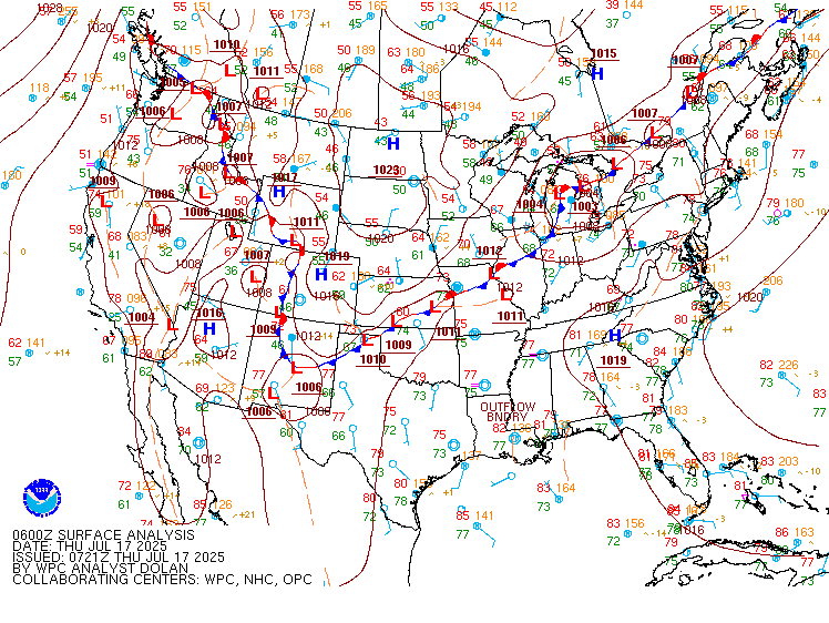
Excessive Rainfall Discussion
NWS Weather Prediction Center College Park MD
847 PM EDT Thu Jul 17 2025
Day 1
Valid 01Z Fri Jul 18 2025 - 12Z Fri Jul 18 2025
...THERE IS A SLIGHT RISK OF EXCESSIVE RAINFALL ACROSS THE CENTRAL
GULF COAST, PARTS OF THE SOUTHWEST, AND MID-MISSISSIPPI VALLEY
EAST TO THE MID ATLANTIC...
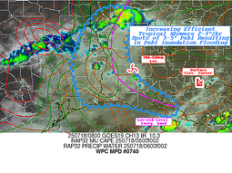
...Northern Gulf Coast...
0100Z update...Based on the latest observational trends (transitory
ands of heavier rainfall, cloud tops beginning to warm), have
removed the Moderate Risk from the LA Coast.
...Southwest...
1945Z Update...Expanded the Slight Risk area down through the
Sacramento Mtns in eastern NM based on the latest observational
trends and latest (18Z) HREF 1/3/6 hour QPF exceedance
probabilities.
...Ozarks to the Ohio River Valley and Mid Atlantic...
1945Z update...Expanded the Slight into the parts of the VA/NC
Coastal Plain. Despite the westerly (downsloping) low-level flow,
the degree of deep-layer moisture availability (2.1-2.3+ inches)
along with instability (mixed-layer CAPEs 3000-3500 J/Kg) will make
for locally intense (potentially significant) short-term rainfall
rates along/near the leeside trough, with some weak/transient upper
shortwave energy. This despite the relatively progressive storm
motions compared to the last few days, as the strength of the low-
level flow vs. 850-300 mb mean flow would suggest an enhanced risk
of west-east cell training.
Hurley
Day 1 threat area:
www.wpc.ncep.noaa.gov/qpf/94epoints.txt
Excessive Rainfall Discussion
NWS Weather Prediction Center College Park MD
415 AM EDT Fri Jul 18 2025
Day 1
Valid 12Z Fri Jul 18 2025 - 12Z Sat Jul 19 2025
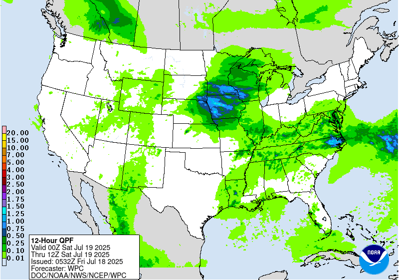
...THERE IS A MODERATE RISK FOR EXCESSIVE RAINFALL FOR THE NORTHERN
SHENANDOAH VALLEY OF NORTHERN VIRGINIA...
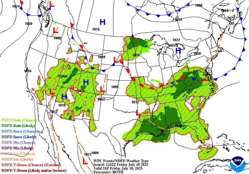
...Mid-Atlantic...
The biggest changes for today's outlook were made across the Mid-
Atlantic. Abundant moisture that has been in place across much of
the Mid-Atlantic for at least the past week will only build today
as a steady supply of deep tropical moisture from the Gulf pushes
northeastward across the South and into the Mid-Atlantic. This
moisture will contain ample instability for storms to draw on as
MUCAPE values exceed 3,000 J/kg across much of VA and points south.
The primary forcing will be a back door front of sorts, though it's
more of a dry line. The front will gradually sag southward, making
the most southward progress down the coast. Thus, the front will
become more northwest-to-southeast oriented with time. The front
acting as a focal point for lift will allow widespread shower and
thunderstorm activity to develop across West Virginia as early as
mid-to-late-morning. As these storms progress eastward, they will
encounter areas that have been hard-hit with heavy rain and
therefore have swollen streams and creeks and saturated soils, such
as in the northern Shenandoah Valley. After the first round of
storms moves through around midday or so, additional storms will
quickly develop behind it over the northern Shenandoah Valley and
then they too will push southeastward, gradually organizing into
clusters and lines of storms. The likelihood for the northern
Shenandoah Valley to act as a focus for the storms to initially
develop and organize has increased markedly with the latest
guidance. HREF probabilities of exceeding 3 and 6 hour FFG values
are over 70% through the late afternoon. This is in significant
part due to the aforementioned saturated soils across the area.
Further, neighborhood probabilities of exceeding 3 inches of
rainfall are over 70% for the afternoon period, and over 25% for
exceeding 5 inches of rain. Much of that rain will fall with the
heaviest storms, as local rainfall rates may exceed 3 inches per
hour at times.
For these reasons, in coordination with LWX/Sterling, VA forecast
office, a Moderate Risk upgrade was introduced with this update for
the I-81 corridor in the northern Shenandoah Valley, which includes
the westernmost portion of I-66. Elsewhere, the Slight Risk was
expanded north and west with the latest guidance suggesting morning
convection will impact far northern West Virginia, and likely train
as it moves into far western Maryland. Recent rainfall and the very
flashy nature of the streams and creeks in that area also support
the Slight Risk upgrade in these areas.
...Gulf Coast...
The tropical disturbance centered near New Orleans and Lake
Pontchartrain at the time of this writing continues to produce
very limited shower and thunderstorm activity well to its west over
southwestern Louisiana. Over the next few predawn hours,
thunderstorm activity is likely to markedly increase both east and
west of the center of circulation. To the west, the northerly flow
west of the center will collide with the broader southerly flow
over much of the rest of the Gulf, likely leading to a localized
convergence zone near the southwestern Louisiana coast. This will
result in a localized maximum of rainfall in that area. Meanwhile
to the center's east, the complimentary southerly flow over the
Gulf and east of the center will support strong advection of deep
tropical moisture. North-south oriented lines of cellular
convection will developing also likely near the coast, where
frictional convergence increases. These lines are likely to remain
nearly stationary since the center of circulation will be moving
nearly due north, so the forcing from the low center will remain
steady state. For these reasons, the Slight Risk in the ERO was
maintained largely unchanged, though there will likely be a minimum
of thunderstorm activity in between these two maxima in eastern
Louisiana. Despite this minimum, the abundance of tropical moisture
present will still support isolated to widely scattered convection
near the center which will be very capable of embedded heavy
rainfall.
...Midwest...
The nose of a potent southwesterly LLJ will intrude into the
Iowa/Minnesota/Wisconsin area through the day today. As an upper
level shortwave digs south out of the jet over northern Minnesota,
the front at the nose of the LLJ will act as a focal point for
strong thunderstorms. PWATs will increase above 1.75 inches over
the area, which will supply plentiful fuel for the thunderstorms to
produce cells of heavier rainfall as they track southeastward along
the front. The LLJ will support backbuilding and training storms as
the moisture and instability supply with the LLJ remains in place
to allow for additional thunderstorm development behind any initial
line of storms. As the storms move into the instability, expect any
initial clusters to organize into one or two lines of storms as
they press into Iowa. Due to the potential for heavy rain and
recent heavy rainfall having partially saturated the soils in the
area, the Slight Risk remains in place across the region,
particularly for the localized areas where storms train and
backbuild. The rather fast movement of the storms should somewhat
limit the flash flooding potential, so the area remains a lower end
Slight.
...Southwestern New Mexico...
A tongue of higher moisture across southwestern New Mexico today
will act as a focus for widespread shower and thunderstorm activity
this afternoon with maximum daytime heating. The showers and storms
will be capable of locally heavy rainfall, though PWATs only around
1.25 inches may limit the overall coverage of any heavier
convection. The storms may organize around any local terrain
features. Local burn scars and shallow soils will both contribute
to potential flash flooding as the rainfall quickly flows into the
local streams and rivers. The Slight was left unchanged from
inherited as guidance remains in good agreement on the location of
the highest flash flooding potential.
...Eastern Nevada...
The Slight Risk area across eastern Nevada and a sliver of Utah
also remains unchanged with this update. A slow, northward moving
upper level low will help concentrate the available atmospheric
moisture in the area to allow any storms that form with afternoon
heating to persist and perhaps organize into a slow-moving line of
storms by the evening hours. The Slight Risk area was unchanged
from the previous update in this area.
Wegman
Day 1 threat area:
www.wpc.ncep.noaa.gov/qpf/94epoints.txt
Excessive Rainfall Discussion
NWS Weather Prediction Center College Park MD
415 AM EDT Fri Jul 18 2025
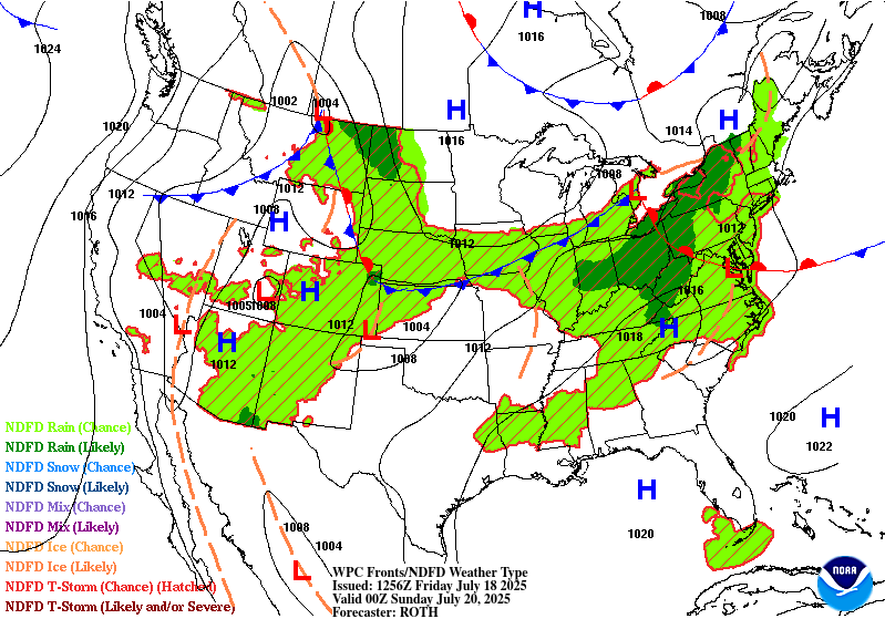
Day 2
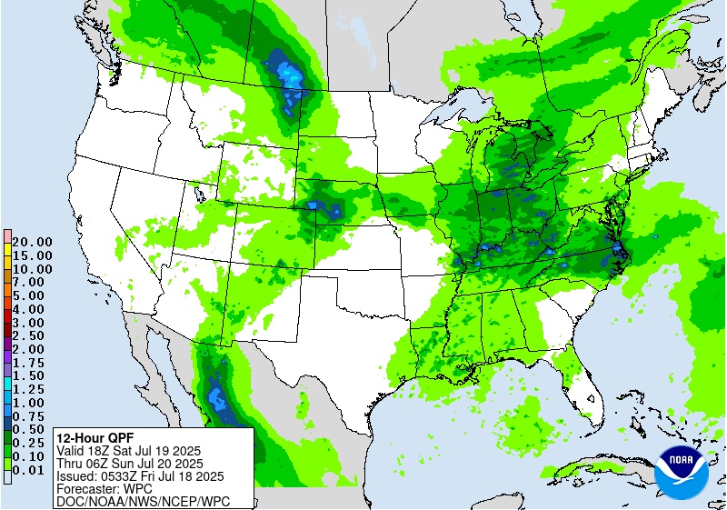
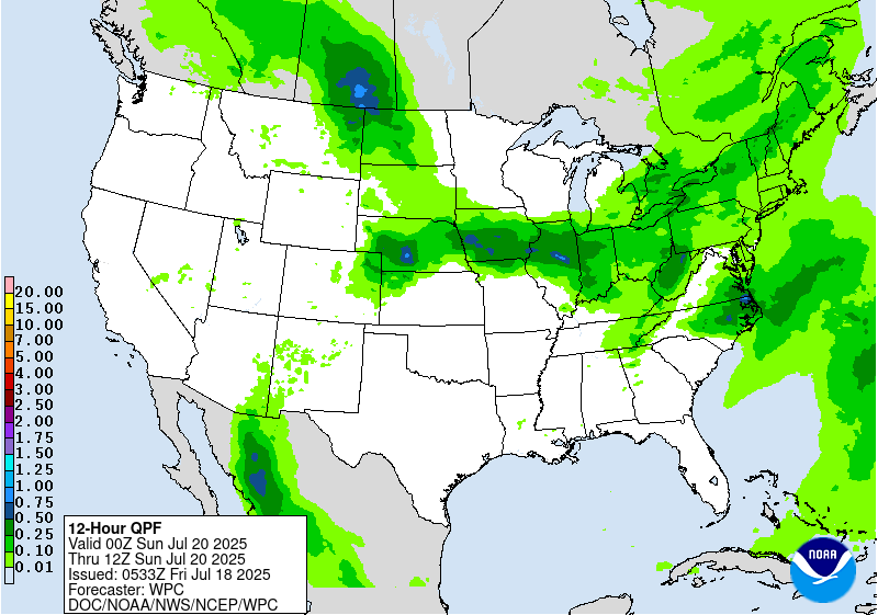
Valid 12Z Sat Jul 19 2025 - 12Z Sun Jul 20 2025
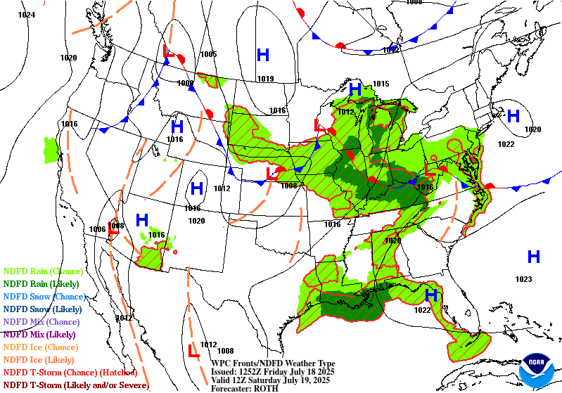
...THERE IS A SLIGHT RISK OF EXCESSIVE RAINFALL FOR PORTIONS OF THE
MIDWEST INTO THE TENNESSEE VALLEY AND THE SOUTHERN MID-ATLANTIC...
Ample tropical moisture, at least in part associated with the plume
of moisture associated with the low over Louisiana will stream
northeastward on a continuous low level jet. As that moisture runs
into a stationary front set up over the Midwest, it will be lifted,
resulting in numerous showers and thunderstorms all across the
region. The guidance is in poor agreement as to how those
thunderstorms will organize. What appears most probable is the
cluster of thunderstorms from the upper Midwest on Day 1/Friday
will continue southeastward along the front, able to easily sustain
itself due to the abundant tropical moisture in place across much
of the eastern half of the US.
With daytime heating, clusters of showers and thunderstorms will
develop ahead of this aforementioned line. Cell mergers and the
eventual congealing of the storms with the line will allow quite a
few areas across the Midwest to have multiple rounds of storms to
impact the area. This will likely result in widely scattered to
scattered instances of flash flooding. Areas hard hit with heavy
rainfall in previous days would be particularly vulnerable to
additional flash flooding should multiple rounds of storms move
over those communities.
Wegman
Day 2 threat area:
www.wpc.ncep.noaa.gov/qpf/98epoints.txt
Excessive Rainfall Discussion
NWS Weather Prediction Center College Park MD
415 AM EDT Fri Jul 18 2025
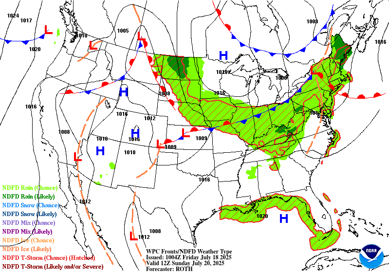
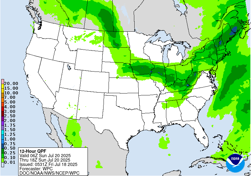
Day 3
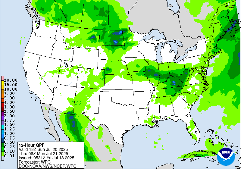
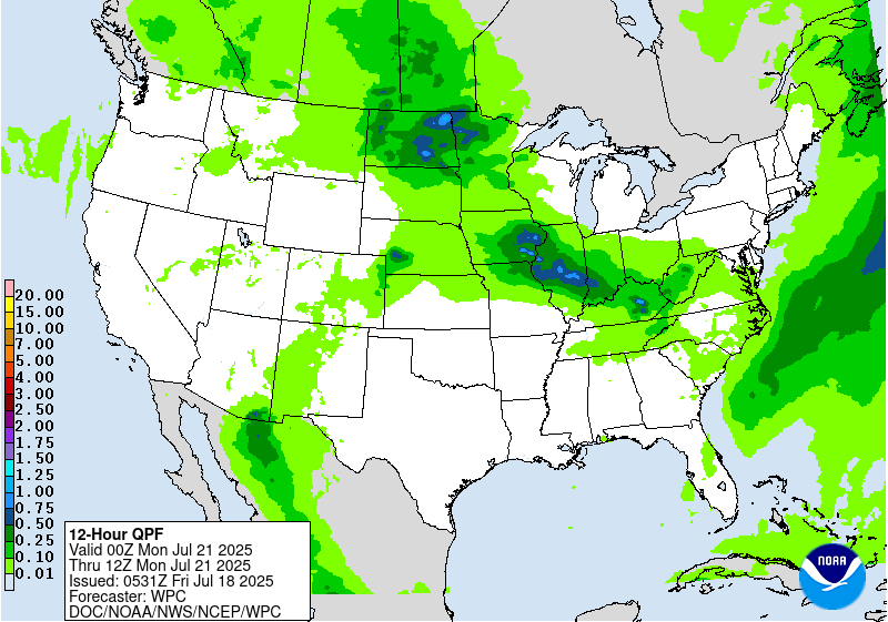
Valid 12Z Sun Jul 20 2025 - 12Z Mon Jul 21 2025
...THERE IS A SLIGHT RISK OF EXCESSIVE RAINFALL FOR PORTIONS OF THE
MIDWEST AND NORTHERN PLAINS...
...Midwest...
A complex setup looks to unfold across this region on Sunday. A
line of storms will move southeastward from the Mississippi River
Valley across the Ohio Valley. With ample daytime heating and a
stationary front still in place. Widespread thunderstorms will
develop along the frontal interface. The storms will interact with
each other, likely congealing into clusters as the line absorbs the
storms from northwest to southeast. Behind this line however,
additional storms are likely to develop overnight Sunday night,
especially for western areas in Iowa and Illinois. The slow moving
nature of the storms at the nose of the jet will increase the flash
flooding threat in that region as well. Further, all of the Slight
Risk area will have been through storms from the Day 2/Saturday
period, so soils are likely to be more responsive to flash flooding
should storms occur in these same areas again on Sunday. There is
some uncertainty as to where the storms will align, which will
depend on frontal position. Much of the guidance has trended a bit
southwestward, so the Slight was trimmed out of northern Indiana
and Illinois with this update in favor of the central portions of
those same states. Into Kentucky and the western Virginias, terrain
and recent heavy rainfall increase the flash flooding threat
further in these areas, where a higher end Slight remains in
effect.
...Northern Plains...
Much of North Dakota will be at the nose of a potent low level jet
across the area. A subtle shortwave in the upper level jet may be
all it takes to initiate a line of storms across the region,
especially Sunday night, though there may be two separate rounds:
one in the morning and a second Sunday night. There is considerable
uncertainty both with storm intensity and receptivity of the ground
to the heavy rainfall. Due to this uncertainty, the Slight Risk
area was left unchanged with this update, but is considered a lower
end Slight.
Wegman
Day 3 threat area:
www.wpc.ncep.noaa.gov/qpf/99epoints.txt
Extended Forecast Discussion
NWS Weather Prediction Center College Park MD
238 AM EDT Fri Jul 18 2025
It remains the case that a corridor of unsettled weather will
remain in place from the Upper Midwest to the Southeast coast for
the beginning of the week. Thunderstorm complexes traveling around
the northern periphery of the big upper high will likely produce
localized areas of heavy rainfall, potentially exceeding an inch
per hour or more. Therefore, a broad Marginal Risk area extends
from the eastern Dakotas, through the Ohio Valley, and to northern
Florida and the coastal Carolinas for both Days 4 and 5 (Monday and
Tuesday). A Slight Risk area has been introduced from eastern Iowa
to west-central Indiana on Monday/Day 4 where the guidance and NBM
has a more concentrated QPF signal, with a high CAPE and high PW
environment in place, and this is also across areas that are
expected to have noteworthy rainfall in the days leading up to
this, with soils likely to be quite saturated in many cases.
Heat will once again make weather headlines for much of next week
across a large portion of the southern and central U.S. with a
large upper high becoming anchored over the Mid-South. Widespread
major impacts on the Heat Risk scale are expected from the Central
Plains to the Southeast states early in the week, and these higher
impacts then reach the Midwest and Ohio Valley by mid to late week.
This will be due to widespread highs in the middle 90s to low 100s
for many of these areas, in combination with dewpoints well into
the 70s, and overnight lows remaining uncomfortably warm. This will
likely have some staying power beyond this forecast period based
on the latest week two outlook from the Climate Prediction Center
from the Central Plains to the Deep South.
Elsewhere across the nation, there should be just enough monsoonal
moisture in place across eastern Arizona and much of New Mexico,
and probably extending into southern portions of Colorado, and
given the potential for some isolated slow moving storms, a
Marginal Risk is in place for both Monday and Tuesday. Across the
East Coast region, a cold front is forecast to clear the Northeast
and the Mid-Atlantic region, and bringing a higher quality airmass
after all of the heat and oppressive humidity lately and lower rain
chances. However, the heat will likely return towards the end of
the week as the Canadian surface high moves offshore and a more
southerly flow commences.
Hamrick


