Excessive Rainfall Discussion
NWS Weather Prediction Center College Park MD
908 PM EDT Sun Jul 27 2025
Day 1
Valid 01Z Mon Jul 28 2025 - 12Z Mon Jul 28 2025
...THERE IS A SLIGHT RISK OF EXCESSIVE RAINFALL OVER PORTIONS OF
THE UPPER MS VALLEY AND THE OH VALLEY TO THE MID ATLANTIC...
01Z Update...
Made a few additional changes, including continuing to reduce the
footprint and shift south the Slight Risk over the Ohio Valley to
Mid Atlantic, as drier and more stable air presses in from the
north.
Back across far eastern South Dakota into southern Minnesota - while
some training and backbuilding continues, radar shows the initial
storms that developed have now pushed south of the areas impacted
earlier by the heaviest amounts. Model consensus indicates this
trend will continue through the remainder of the evening into the
overnight.
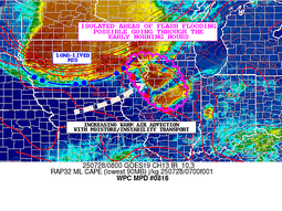
23Z Special Update...
...Upper MS Valley...
Repositioned the Slight Risk over the Upper Midwest/MS Valley
further south across southern Minnesota into northern Iowa. A
cluster of storms over the area is currently producing rainfall
rates over 2 in/hr within some of the stronger cells. With deep
moisture in place and an environment favorable for backbuilding and
training storms, additional heavy rainfall is likely into the
evening. The heavy rainfall threat is expected to diminish by the
overnight as a cold pool develops and storms begin to propagate
more quickly to the southeast.
For more details on the near-term threat, see WPC MPD #813.
...Ohio Valley to the Mid Atlantic...
Shifted the Slight Risk further to the south, where storms
continue to develop along a slow-moving, west-east oriented outflow
boundary. Further to the north, drier and more stable air has
spread south across the Northeast, so the Slight Risk that extended
north across portions eastern Pennsylvania, New Jersey, and
Upstate New York was removed.
...Southwest...
Made only minor adjustments to the Marginal Risk over New Mexico
and southeastern Arizona.
Pereira
Day 1 threat area:
www.wpc.ncep.noaa.gov/qpf/94epoints.txt
Excessive Rainfall Discussion
NWS Weather Prediction Center College Park MD
413 AM EDT Mon Jul 28 2025
Day 1
Valid 12Z Mon Jul 28 2025 - 12Z Tue Jul 29 2025
...THERE IS A SLIGHT RISK OF EXCESSIVE RAINFALL OVER PORTIONS OF
THE NORTHERN PLAINS AND UPPER MISSISSIPPI VALLEY..
...Northern Plains to Upper MS Valley...
Convection will move across portions of eastern MT and into the
western Dakotas this morning. Heavy rainfall rates with this
activity will pose a localized flash flood risk, however generally
quick cell motions should limit the extent of the threat. As we
head into the afternoon and evening hours this convection will
grow upscale into an MCS as it moves across central SD into
southern MN and northern IA. A forward propagating derecho is
likely given the environmental ingredients in place and per SPC.
This fast forward motion will likely cap the extent of any flash
flood risk at the Slight level.
The impressive CAPE and PWs around 2" near and just downstream of
the MCS will support heavy rainfall rates. As the MCS matures the
heaviest rainfall totals may end up near the developing comma
head/bookend vortex where rainfall duration will be locally longer.
The 00z HREF supports total rainfall over 2", with a narrow axis
of over 3" probable as well. Portions of eastern SD into southwest
MN received heavy rainfall this past night...and so if an
additional 2-3" falls over these areas then isolated to scattered
flash flooding is likely. Elsewhere, the threat is likely an urban
risk driven by hourly rainfall locally as high as 2" as the MCS
moves through.
...Southwest..
Another day of scattered afternoon convection expected across much
of NM into far southeast AZ. Both PWs and CAPE are forecast to be
higher today compared to yesterday, and so do anticipate a bit
more convective coverage today. Activity will initially develop
near areas of terrain, such as the Sacramento Mountains and Sangre
De Cristos. Given the moisture and instability in place...at least
an isolated flash flood threat is likely on/near these higher
terrain areas, especially over the more sensitive burn scars. Cells
may tend to be transient today...either moving off to the west
and/or dissipating fairly quickly, which may keep the flash flood
coverage isolated in nature. Convection could actually persist into
the overnight hours over portions of southern NM...but the extent
of instability by this time is unclear, and so rainfall rates
should be tempered by this time. Overall this is a solid Marginal
risk with isolated flash flooding likely, but at the moment think
the risk falls just shy of Slight risk level coverage.
...OH Valley into the Carolinas...
Isolated to scattered thunderstorms are expected today across a
broad area stretching from KY/TN to southern MI and all the way to
the coastal Carolinas. Generally not expecting much organization
to convection...but PWs of around 2" (or higher) will continue to
support heavy rainfall rates. Localized rainfall of 2-3" are
possible within the Marginal risk area...and while the coverage of
these amounts should be small...where it does fall some flash
flood impacts are possible within areas of lowered FFG. The most
concentrated probabilities in the HREF are actually over the
coastal Carolinas, where a convergence axis should drive more
convective coverage and some totals locally over 3". However with
higher FFG over these areas the flash flood risk is still expected
to stay isolated.
Chenard
Day 1 threat area:
www.wpc.ncep.noaa.gov/qpf/94epoints.txt
Excessive Rainfall Discussion
NWS Weather Prediction Center College Park MD
413 AM EDT Mon Jul 28 2025
Day 2
Valid 12Z Tue Jul 29 2025 - 12Z Wed Jul 30 2025
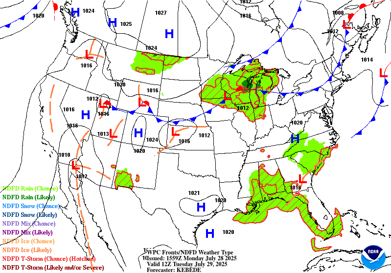
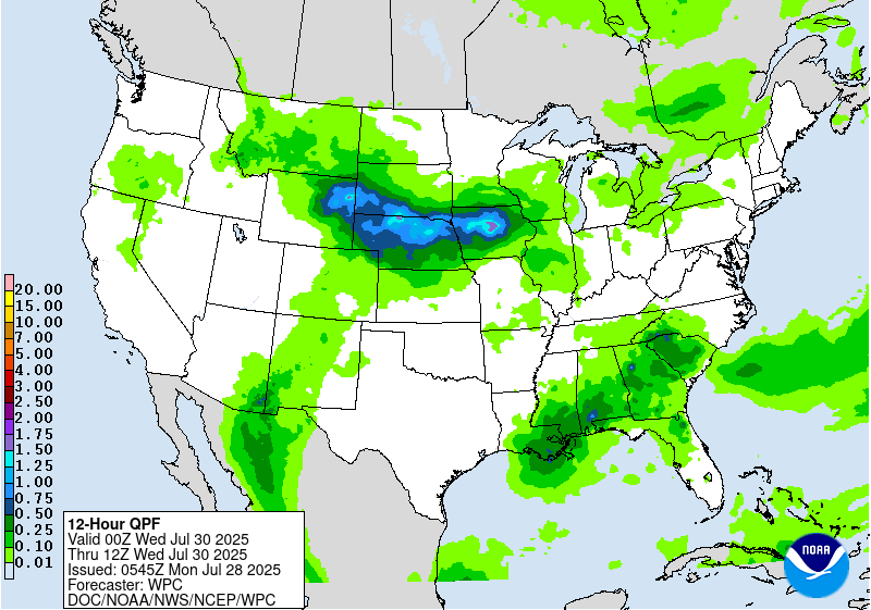
...THERE IS A SLIGHT RISK OF EXCESSIVE RAINFALL OVER PORTIONS OF
THE CENTRAL AND NORTHERN PLAINS...
...Central and Northern Plains...
A stationary front will likely extend across southern IA/NE and
into the High Plains on Tuesday afternoon/evening. Easterly flow to
the north of this front will likely help trigger convective
development over the High Plains as shortwave energy moves out of
the Rockies and upper level divergence increases in the right
entrance region of an upper jet. This activity will likely push
east into the overnight hours across NE and eventually IA
along/north of the stationary front. Upscale development into an
MCS appears probable driving a heavy rainfall threat. Any eventual
MCS will probably propagate off to the east fairly quickly, however
additional development downstream over NE/IA is possible given the
convergence near the front and what should be CAPE around 4000
j/kg. PWs should be plenty high enough for heavy rainfall, ranging
from 1.5" in the High Plains to locally over 2" from eastern NE
into IA.
There remains some latitudinal uncertainty with the axis of
convection during this period...although the general trend has
been for a slightly farther south axis. There is also some question
as to how far east the risk exists, with the deterministic and
ensemble EC and the 00z RRFS/REFS favoring NE, but the GFS and
AIFS extending the threat into IA. Given a favorable track record
for the AIFS and the presence of the boundary/instability/PWs over
IA, we did want to make sure that the Slight risk at least covered
into central IA.
...Southwest...
Another day of scattered afternoon convection expected Tuesday.
Probabilities from both the 00z HREF and REFS show a bit more
persistence of high 1"/hr exceedance over the Sacramento Mountains
and vicinity. Thus the flash flood risk over these areas, and the
susceptible burn scars, may very well be higher Tuesday than
Monday. However there are some questions regarding the coverage of
heavier rainfall amounts away from these terrain areas, as the
overall coverage could be a bit less than Monday. Given the small
extent of the higher risk at the moment and the uncertainty on the
broader coverage, we will leave the ERO at a Marginal level
pending what happens Monday. Although locally significant impacts
are possible within/near the Sacramento Mountain burn scars.
...Southeast...
Expecting greater convective coverage on Tuesday from the Southeast
into the southern Appalachians. Not much in the way of forcing to
organize convection, and generally expecting pulse activity that
does not last all that long at any one location. This will act as
a limiting factor for flash flooding...however there should be
enough convective coverage that some cell mergers along outflows
will be a possibility. PWs in the region are forecast between 2"
and 2.3", with CAPE over 2000 j/kg...so the thermodynamic
environment will support heavy rainfall rates. Thus even with a
relatively short duration of rain at any one location, rainfall
totals locally over 3" appear probable driving a localized flash
flood risk.
Chenard
Day 2 threat area:
www.wpc.ncep.noaa.gov/qpf/98epoints.txt
Excessive Rainfall Discussion
NWS Weather Prediction Center College Park MD
413 AM EDT Mon Jul 28 2025
Day 3
Valid 12Z Wed Jul 30 2025 - 12Z Thu Jul 31 2025
...THERE IS A SLIGHT RISK OF EXCESSIVE RAINFALL OVER PORTIONS OF
THE MIDDLE MISSISSIPPI VALLEY...
...Mid MS Valley...
At 12z Wednesday it seems likely that we will have some degree of
organized convection ongoing in the vicinity of IA, although at
this lead time getting these specifics right is tricky.
Nonetheless, it appears probable that a better defined
shortwave/MCV will be associated with this convection and slowly
move east across IA/MO/IL and vicinity Wednesday into Wednesday
night. Meanwhile we will have a slowly southward shifting cold
front helping focus convergence, and the right entrance region of
the upper jet adding some divergence aloft. With plentiful CAPE
near the front and PWs locally over 2", the ingredients for areas
of excessive rainfall are in place. Some uncertainty remains on the
details...but 00z models are coming into a better consensus on the
favored axis for heavy rainfall..generally stretching across
portions of IA, northern MO and into central/northern IL and
possibly portions of IN.
...Southwest and High Plains...
Isolated to scattered convection will likely develop near areas of
terrain from NM into the Rockies. Generally not looking like the
greatest forcing, so the degree of convective organization remains
unclear. At the moment most models indicate mostly
isolated/scattered development, and generally not enough coverage
for anything more than a Marginal risk. However there is some
potential for a few organized clusters to move off the terrain
into the High Plains, and so can not rule a targeted Slight risk or
two as we get closer in time and have more high res guidance to
interrogate.
...Elsewhere...
A broad Marginal risk extends from the central Gulf Coast all the
way into portions of New England. High PWs and CAPE and convective
coverage will drive the risk from the Gulf Coast into the TN
valley. A lack of organization may keep FFG exceedance coverage
down, but high rainfall rates will likely locally approach or
exceed FFG. A cold front will drive the risk form portions of the
OH valley into New England. Generally quick cell motions and the
lack of a significant QPF footprint in the 00z models keep this
risk at a Marginal level.
Chenard
Day 3 threat area:
www.wpc.ncep.noaa.gov/qpf/99epoints.txt
Extended Forecast Discussion
NWS Weather Prediction Center College Park MD
259 AM EDT Mon Jul 28 2025
The cold front pushing through the East will provide a focus for
ample moisture and instability to pool while there should be
increasing dynamical support in the form of the right entrance
region of the upper jet. High rain rates in widespread
thunderstorms should lead to a flash flooding risk, and a Slight
Risk remains in place in the Day 4/Thursday ERO for the Mid-
Atlantic, parts of which are starting with wetter than average
antecedent conditions that could augment the flooding risk. The
Slight has been expanded north into southern parts of the Northeast
per recent model guidance indicating the front moving more slowly
south than previous forecasts. By Friday the front is forecast to
push into the Carolinas, and show a Slight Risk for the new Day
5/Friday ERO there into the southern Appalachians and eastern
Georgia with similar environmental factors as Thursday farther
north. The Carolinas may see additional convection into the
weekend. The front stretching west across the Gulf Coast states in
a moist and unstable environment could promote scattered diurnal
thunderstorms there through late week into the weekend, and
Marginal Risks are in place in the Day 4/5 EROs due to high rain
rates that may overcome the high Flash Flood Guidance and/or fall
atop urban areas.
Farther west as the front bends back into the Plains, rounds of
rain and thunderstorms are likely with possibly multiple MCSs. Some
shortwave forcing and above normal moisture and instability should
lead to high rain rates, and some areas could see repeating rounds
of storms with the front stalling. For Day 4/Thursday, the ERO
depicts a Slight Risk over the central Plains where there may be a
particular focus for rain. Broad Marginal Risks cover much of the
High Plains on both Days 4 and 5 and back into the northern
Rockies/High Plains near the back end of the front as much higher
than average instability (per the Extreme Forecast Index) is in
place. Farther south, monsoonal moisture (with precipitable water
values generally in the 75th-90th percentile) will be present over
the Southwest with some instability. Marginal Risks are in place in
the Days 4 and 5 EROs for parts of the Southwest, reaching into
the central Rockies/High Plains as as the monsoonal moisture meets
the frontal system to the north. Moisture looks to lessen in the
Southwest by the weekend.
Another hot day is forecast for the Carolinas into Georgia and
Florida Thursday ahead of the cold front and under what remains of
the short range upper ridge. HeatRisk is mainly in the Major (level
3/4) category with some embedded Extreme (level 4/4) areas as
temperatures reach well into the 90s with higher heat indices
(nearing 110F), while morning lows well into the 70s and nearing 80
will not provide much relief. The cold front gradually passing
through the Southeast will bring moderating temperatures, and
Florida will be the last to see relief from the heat this weekend.
Cooler than average temperatures (especially highs) are likely in
the northern/central Plains on the cool side of the front and with
the clouds and rain chances -- a few locations may even challenge
record cool maxes for the day (low 70s). Meanwhile the Southwest
can expect seasonable heat, with desert areas seeing temperatures
around 110 degrees.
Tate


