Excessive Rainfall Discussion
NWS Weather Prediction Center College Park MD
858 PM EDT Sun Jul 20 2025
Day 1
Valid 01Z Mon Jul 21 2025 - 12Z Mon Jul 21 2025
...THERE IS A MODERATE RISK OF EXCESSIVE RAINFALL ACROSS PORTIONS
OF NORTHEAST MISSOURI, CENTRAL ILLINOIS AND SOUTHWEST INDIANA...
...MS Valley into the OH Valley...
The inherited Moderate risk was expanded and now includes portions
of northeast MO into central IL and southwest IN. Some training
west to east convection is ongoing across portions of central IL
and adjacent areas of IN as of 01z. As we head into the overnight
hours convection should expand as low level moisture
transport/convergence increases across the region. The
thermodynamic environment is impressive...with MLCAPE around 3000
J/KG and PWs between 2" and 2.4". These ingredients will support
very heavy rainfall rates, with 2-3" per hour rainfall likely in
spots. This will be enough to result in scattered to numerous
instances of flash flooding as we head into the overnight hours.
Locally significant impacts are possible...especially if any more
sensitive urban or low lying areas are impacted by these intense
rainfall rates.
There remains some uncertainty on how exactly convection will
evolve tonight and where any more robust training axis will set
up. The expansion of the MDT risk accounts for this lingering
uncertainty and a modest southward trend seen in some of the newer
high res guidance. There is still enough run to run volatility in
the HRRR to keep confidence on the exact details lower...however as
mentioned above, the ingredients are there for excessive rainfall
and potentially significant impacts. Do expect an axis of training
convection to expand into the overnight hours somewhere within or
very close to the MDT risk area. Some flash flood impacts are also
likely downstream of the MDT risk across the OH valley into WV
through the overnight hours.
...Northern Plains...
Areas of stronger convection will likely move out of the High
Plains and into more of ND, SD and northern NE into the overnight
hours. Most of these cells should have enough forward movement to
limit the flash flood risk. Those cells that do slow and briefly
train should be small enough in scale that flash flooding coverage
into the overnight hours should stay localized.
...NM/CO...
Isolated flash flooding is possible this evening from northeast NM
into eastern CO where increasing coverage of slow moving cells
will bring areas of locally heavy rainfall.
Chenard
Day 1 threat area:
www.wpc.ncep.noaa.gov/qpf/94epoints.txt
Excessive Rainfall Discussion
NWS Weather Prediction Center College Park MD
412 AM EDT Mon Jul 21 2025
Day 1
Valid 12Z Mon Jul 21 2025 - 12Z Tue Jul 22 2025
...THERE IS A SLIGHT RISK OF EXCESSIVE RAINFALL FOR MUCH OF
KENTUCKY, TENNESSEE, AND PORTIONS OF THE SOUTHERN APPALACHIANS...
...Southern Ohio Valley into the Southern Appalachians...
Evolving pattern with a seasonally strong surface ridge to the
north will aid in pressing the persistent quasi-stationary boundary
across the Mid Atlantic and Ohio Valleys to the south leading to a
degrading precip field north of the front, but maintaining
convective posture along and south of the boundary. A panoply of
weak shortwave perturbations will be rippling through southern Ohio
Valley into the southern Mid Atlantic on Monday with expected
diurnal destabilization over much of KY/TN into southwestern VA
leading to another period of scattered to widespread convective
flare ups in the prevailing warm sector. A relatively buoyant
environment in place across the above areas will promote locally
heavy downpours capable of rates >2"/hr, something that has been
customary within this persistently moist airmass lingering from the
western fringes of the Western Atlantic ridge. Expect PWATs to hang
within the +1 to +2 standard deviation range across the above areas
with the latest 00z HREF mean MUCAPE to hover between 1000-2000
J/kg for much of the Southern Appalachians with 2000-3000 J/kg
presence across much of KY and TN. The elevated CAPE indices
coupled with the moisture rich environment of >2" PWATs will lead
to scattered instances of flash flooding, especially over those
terrain focused areas of eastern KY/TN into southwest VA where
multiple instances of heavy rainfall have led to a series of FFW's
being issued the past several days.
00z HREF neighborhood probs remain high (>60%) for at least 1" of
rainfall with >2" running between 40-60% over a large area
encompassed by low FFG indices for 1/3/6hr increments. The
positioning of the front will be factor for the northern periphery
of the greatest convective reflection in the setup, as well as a
focus for anchored cores that could relish on the capability to
drop between 2-4" of rainfall in spots as depicted within the
latest 00z CAMs suite. Considering both the probabilistic and
deterministic maxima being depicted within the hi-res suite, there
was enough consensus to maintain general continuity of the previous
SLGT risk inheritance with a southward shift in the risk area
overall to reflect the latest trends of frontal positioning and
convective output within the CAMs.
...Southern Mid Atlantic into the Southeast...
Scattered strong convective cores will be capable of heavy rainfall
in pretty much any area within the bounds of southern VA down
through the Carolina's into the Southeastern CONUS. The best
threats for more organized heavy convective regimes will be located
over eastern NC and the north-central FL Peninsula. The two
patterns will not be related in any way, but they do share an
element of robust instability and a foci for convection along a
surface based front/boundary in the form of a cold front (NC) and
surface trough (FL). FFG's within each area are still pretty high
overall for all 1/3/6hr indices, so the threat for more widespread
flash flood concerns is lower, but still worthy of a risk
considering the environmental factors in play. Elevated probs for
>3" locally (50-70%) are sufficient for those flash flood concerns
for each area respectively. However, a sharp decline in the
prospects for >5" really mutes the higher risk potential and keeps
the threat within the MRGL threshold. As a result, there was very
little deviation from the previous forecast with only minor
adjustments over the Southern Mid Atlantic coast near the VA
Tidewater. MRGL risk remains in effect.
...Southwest U.S...
The southwestern U.S will maintain a persistent convective posture
with a defined monsoonal axis across NM/AZ with a sharp cutoff in
deeper moisture as you move closer to the Colorado river Basin.
Isolated stronger cores will lead to threats of flash flooding just
about anywhere over the two respective areas with emphasis on those
places dealing with remnant burn scars and complex terrain which
exacerbate flash flooding impacts. Strongest signal for heavy rain
in the prob fields remains parked over southeast AZ with the
Huachuca Mtns. the likely beneficiary of slow-moving thunderstorms
and QPF maxima >1" during time frame of impact (18-03z). A pretty
stable element this time of year with a generally seasonal pattern
in place. This is more than enough to constitute a MRGL risk
issuance given the setup.
...Northern Plains through Upper Midwest...
Two-part convective episode over the northern tier of the CONUS
will lead to a few areas seeing repeated heavy rainfall prospects
in the D1 time frame. The first of which will be the migration of a
complex out of the Dakotas into the Red River/Bois de Sioux basins
that border ND/SD/MN in the early portion of the period with
locally heavy rainfall in wake of the passing complex. Still some
discrepancy on the eastward extent and residual QPF magnitude that
will be produced by the complex, but the pattern generally favors a
weakening component over the area above, so perhaps the threat is
on the lower end for flash flood concerns in the first 6hrs of the
forecast.
The second time frame of interest will arise over the course of the
following evening as an approaching trough axis across the PAC
Northwest will lead to an increasingly diffluent pattern downstream
of the mean trough, promoting favorable large scale ascent from
eastern MT up into the Dakotas. A series of smaller shortwaves will
propagate northeast into the region after 00z with convective
initiation most likely further west with more question marks on the
maintenance of convection as you step eastward. There's a mixture
of results within the CAMs output for whether the pattern evolves
in such that eastern ND into MN gets put into play for heavy
rainfall overnight Monday into early Tuesday, or is a majority of
the pattern only aligned within eastern MT into ND. The split in
guidance has relegated the signal within the EAS to a paltry <10%
for >1" in the 6hr period between 00-06z Tuesday, but we do see an
uptick in the 06-12z Tuesday window, so perhaps it could be more of
a timing of the convective pattern moving downstream with less
focus on discrete activity prior to the advancing convective
complex. The general rule of thumb for these types of patterns is
favoring a lower risk until there's a greater consensus on what
could transpire. This works well within the area of interest due
to modest FFG indices in place and FFG exceedance probs remaining
on the lower end. A broad MRGL risk is in place for the
aforementioned areas with the greatest concerns across the eastern
Dakotas and eastern Montana.
...Pacific Northwest...
Combination of a weak upper low presence over southwest Canada and
the approach of a more robust shortwave trough into the
Northwestern CONUS will lead to focused areas for isolated flooding
concerns within the terrain of northeast OR and the Washington
Cascades. Signals for locally >1" of rainfall are >70% in each
respective locale, but signals in the deterministic are still
spotty in the grand scheme. The pattern is just conducive for these
localized heavy rain prospects in complex terrain and burn scar
remnants located over northern WA state. Weak IVT advection into
the region along with favored large scale ascent downstream of the
approaching trough should lead to periods of convection during the
height of the convective time frame (18-06z). The signal remains
low-end, but enough to warrant two small MRGL risks over the
aforementioned areas.
Kleebauer
Day 1 threat area:
www.wpc.ncep.noaa.gov/qpf/94epoints.txt
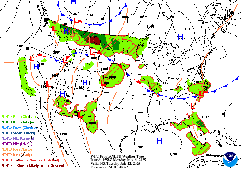
Excessive Rainfall Discussion
NWS Weather Prediction Center College Park MD
412 AM EDT Mon Jul 21 2025
Day 2
Valid 12Z Tue Jul 22 2025 - 12Z Wed Jul 23 2025
...THERE IS A SLIGHT RISK OF EXCESSIVE RAINFALL FOR PORTIONS OF
NORTH DAKOTA, MINNESOTA, NORTHERN WISCONSIN, & NORTHWESTERN
MICHIGAN...
...Northern Plains/Upper Midwest...
Synoptic scale evolution over the northern tier of the CONUS will
lead to a continued unsettled weather pattern with another round of
heavy convection likely to encompass the eastern Dakotas through
parts of the Upper Midwest. A strengthening upper jet over Canada
coupled with shortwave progression from the southwest and budding
LLJ over the Plains/Midwest will lead to a robust axis of
convection running west to east along a bisecting warm front
approach from the south with another cold front slowly migrating
southeast out Canada. As the flow begins more strongly veered
within the boundary layer, the approach of the front and shortwave
trough will lead to the mean flow becoming more parallel to the
frontal boundary leading to more uni-directional mean layer winds
and back-building prospects as Corfidi Upshear forecast shifts
sharply out of the north with weaker storm relative motions. This
is indicative on plenty of the numerical guidance in the vicinity
of north-central MN over into northwest WI and the Arrowhead. The
concern in the setup is the exact positioning of where this back-
building/training axis will transpire as the latitudinal
positioning of the front will make all the difference in where the
heaviest precip will occur and maintain over the back half of the
forecast period. Consensus is still riddled with uncertainty on the
specifics, but the probability fields do note the higher potential
being located along and north of I-94 across ND and western MN.
Greatest threat for significant training seems to be building on a
line from Fargo-Duluth and eventually towards Marquette (More on
that area in the D3 discussion below).
QPF maxima between 4-6" with perhaps a few spots higher when
assessing the different deterministic seems to be the signal as of
now, but we are still only touching the surface of the CAMs.
Considering the environmental parameters (PWATs, instability,
kinematic forcing), the threat is likely well-within the SLGT risk
category with prospects for heavier QPF output as we move closer.
In any case, the SLGT from previous forecast was relatively
maintained with some adjustments on the southern flank of the risk
to note a little more uncertainty in those areas. It's an evolving
setup that could see some shifts in the higher risk area with even
potential for a localized upgrade if consensus on the heaviest
precip axis builds.
...Southeast...
Elevated PWATs and instability across the Southeastern CONUS will
maintain a posture of widely scattered thunderstorms capable of
locally enhanced rainfall rates between 2-4"/hr that could spur
flash flood prospects through the course of Tuesday. A weak surface
reflection along the SC coast with a weak quasi-stationary front
aligned west to east across the Southeast will lead to enhanced
regional convergence that could allow for slow-moving heavy
thunderstorms to train over any area in proxy to these features for
a few hrs. These are the types of setups that can provide a sneaky
3-6" maxima in any given location, especially near the low pressure
center along the coastal plain. Surface trough extending off the
southern flank of the low will likely bisect southeast GA down
through northern FL with guidance consistently pinning a more
defined heavy precip axis within the confines of this area. FFG's
remain very high across that specific area, so the threat for
widespread flash flooding is very low, especially when considering
the probabilities for >5" are still running <20%, a signal
necessary for more appreciable impacts to occur in these zones. In
any case, some of the output from the CAMs is robust locally, so
the threat still falls within the MRGL risk category. The previous
MRGL risk was generally maintained to reflect the persistent
signal, albeit modest at best.
...Southwest...
Another period of monsoonal type convection will enhance localized
flash flood prospects across eastern AZ and much of NM/CO.
Persistent moisture advection along the western flank of a ridge
positioned across the Mississippi Valley will be the driver for the
threat as scattered showers and thunderstorms will litter the
Southwestern CONUS by Tuesday afternoon, carrying through the
evening hrs. Any area within the confines of the above regions will
have a threat for impacts due to convective cores likely producing
rates >1"/hr with upwards of 2"/hr in the strongest cells. Areal
QPF average is generally between 0.25-0.75", but neighborhood probabilities
for >1" over eastern AZ into NM/CO are well above 70% with >2"
probs running between 40-70% over the more terrain favored areas in
both locations. This is more than sufficient for a broad MRGL risk
encompassing these areas with a possibility of a targeted upgrade
if the heavier QPF signals grow within the CAMs in the coming 24
hrs.
Kleebauer
Day 2 threat area:
www.wpc.ncep.noaa.gov/qpf/98epoints.txt
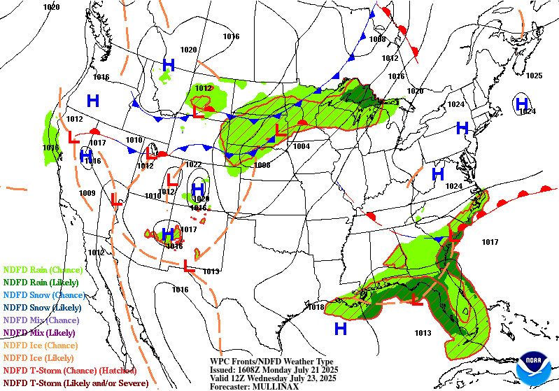
Excessive Rainfall Discussion
NWS Weather Prediction Center College Park MD
412 AM EDT Mon Jul 21 2025
Day 3
Valid 12Z Wed Jul 23 2025 - 12Z Thu Jul 24 2025
...THERE IS A SLIGHT RISK OF EXCESSIVE RAINFALL OVER THE ARROWHEAD
OF MINNESOTA, NORTHERN WISCONSIN, AND THE WESTERN U.P. OF
MICHIGAN...
...Upper Midwest...
The progression of convection from the prior D2 will bleed over
into the front half of D3 with the cold front slowly migrating
eastward allowing some advancement of the organized convective
pattern to spill over into the Arrowhead of MN and adjacent
northern WI and western U.P. There's a better consensus on this
occurring given the aligning mass fields from relevant
deterministic, as well as an agreement on the pattern progression
as the surface low over the northern plains finally lifts northeast
along the front and clears into the northern lakes by Wednesday
afternoon. The cold front will still be slowly pushing eastward
through the second half of the period with guidance indicating
another wave of low pressure potentially enhancing the convective
pattern across the Upper Midwest into the northern Great Lakes.
There's a growing consensus on overlap of the two convective
periods to occur over the far northern tier surrounding Lake
Superior with multi-round QPF forecasts indicating a regional max
positioned over the areas referenced above. A SLGT risk was added
across those respective zones due to confidence in the front end of
the forecast period, but maintained a broad MRGL surrounding with
extension back west where the second round is forecast. There's
still some time to delve into the final details on potential
upgrades across parts of the Plains and Upper Mississippi Valley,
so stay tuned for updates in future forecast packages.
...Southeast...
A slowly westward migrating upper trough off the Southeast coast
and attendant surface low over the northern Gulf will lead to
locally heavy rainfall prospects from the central Gulf coast over
into Florida. The signal for rainfall exceeding 3" can be found in
various deterministic leading to a threat for at least urbanized
centers due to higher run off capabilities. The overall pattern
remains very wet with the greatest instability confined to the
immediate Gulf coast with a secondary maxima over inland central
FL. A MRGL risk remains positioned over the above zones given the
threat with the greatest potential for any upgrades likely over the
immediate central Gulf coast.
Kleebauer
Day 3 threat area:
www.wpc.ncep.noaa.gov/qpf/99epoints.txt
Extended Forecast Discussion
NWS Weather Prediction Center College Park MD
256 AM EDT Mon Jul 21 2025
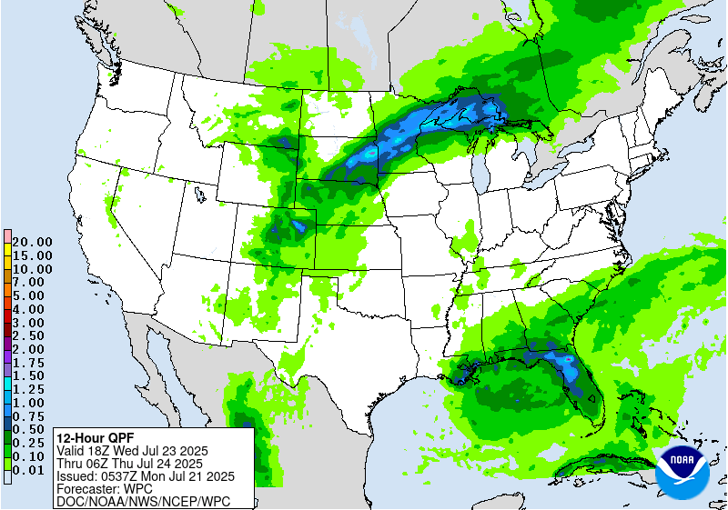
A cold front is progged to slowly drop southward across the Upper
Midwest and Great Lakes region for the end of the week, with a
weak wave of low pressure crossing Lake Superior. This boundary
will be intersecting a warm and very humid airmass, and this is
expected to fuel the development of multiple thunderstorm complexes
from Iowa to Michigan on Thursday, and then across the northern
Ohio Valley and extending to northern New England on Friday. A
Marginal Risk area is valid for both Day 4 and Day 5 for these
regions since some of the storms may have convective training, and
thus increasing the risk of localized flooding where this happens.
Another area of unsettled weather is expected to reside across the
Florida Panhandle and extending westward to southeast Texas to
close out the work week. A surface low is likely to form along a
lingering stationary front, and this should gradually track west
through Friday. The potential exists for several inches of
rainfall in localized cases from southern Louisiana to the Florida
Panhandle, and Marginal Risk areas are valid for Thursday and
Friday to account for this, with some potential for an eventual
Slight Risk in later forecasts as the model guidance comes into
better focus.
Elsewhere across the nation, moisture associated with the Southwest
U.S. monsoon will likely improve compared to recent days, with
some lingering showers/storms across northeast New Mexico and into
eastern Colorado. However, there may be a few convective cells
that are slow moving across burn scar and other sensitive areas,
and therefore a Marginal Risk remain prudent in the excessive
rainfall outlook for Thursday, but currently not needed for Friday.
Across the Dakotas and into western Minnesota, the next frontal
boundary approaching from central Canada will likely have enough
moisture with it to fuel the development of more showers and
thunderstorms, some of which may develop into complexes with
multiple rounds of rainfall. Therefore, a Marginal Risk area will
be valid here for Friday.
The other big story will be the building heat across a large
portion of the east-central U.S. for the second half of the week
and into next weekend, courtesy of a large upper high becoming
anchored over the Mid-South. Heat Risk in the major category will
be prevalent from the Deep South to the Midwest and extending
eastward to include Tennessee and Ohio River Valleys to close out
the work week. Some of this heat will likely reach the East Coast
by Friday and next weekend following the pleasant stretch of
cooler weather for the first half of the week. Highs well into the
90s and even some low 100s will be commonplace from the Central
Plains to the East Coast, with the hottest readings across
Oklahoma, Texas, and Arkansas. It will also be uncomfortably warm
and humid at night, providing only limited relief from the heat.
Hamrick
Extended Forecast Discussion
NWS Weather Prediction Center College Park MD
256 AM EDT Mon Jul 21 2025
A cold front is progged to slowly drop southward across the Upper
Midwest and Great Lakes region for the end of the week, with a
weak wave of low pressure crossing Lake Superior. This boundary
will be intersecting a warm and very humid airmass, and this is
expected to fuel the development of multiple thunderstorm complexes
from Iowa to Michigan on Thursday, and then across the northern
Ohio Valley and extending to northern New England on Friday. A
Marginal Risk area is valid for both Day 4 and Day 5 for these
regions since some of the storms may have convective training, and
thus increasing the risk of localized flooding where this happens.
Another area of unsettled weather is expected to reside across the
Florida Panhandle and extending westward to southeast Texas to
close out the work week. A surface low is likely to form along a
lingering stationary front, and this should gradually track west
through Friday. The potential exists for several inches of
rainfall in localized cases from southern Louisiana to the Florida
Panhandle, and Marginal Risk areas are valid for Thursday and
Friday to account for this, with some potential for an eventual
Slight Risk in later forecasts as the model guidance comes into
better focus.
Elsewhere across the nation, moisture associated with the Southwest
U.S. monsoon will likely improve compared to recent days, with
some lingering showers/storms across northeast New Mexico and into
eastern Colorado. However, there may be a few convective cells
that are slow moving across burn scar and other sensitive areas,
and therefore a Marginal Risk remain prudent in the excessive
rainfall outlook for Thursday, but currently not needed for Friday.
Across the Dakotas and into western Minnesota, the next frontal
boundary approaching from central Canada will likely have enough
moisture with it to fuel the development of more showers and
thunderstorms, some of which may develop into complexes with
multiple rounds of rainfall. Therefore, a Marginal Risk area will
be valid here for Friday.
The other big story will be the building heat across a large
portion of the east-central U.S. for the second half of the week
and into next weekend, courtesy of a large upper high becoming
anchored over the Mid-South. Heat Risk in the major category will
be prevalent from the Deep South to the Midwest and extending
eastward to include Tennessee and Ohio River Valleys to close out
the work week. Some of this heat will likely reach the East Coast
by Friday and next weekend following the pleasant stretch of
cooler weather for the first half of the week. Highs well into the
90s and even some low 100s will be commonplace from the Central
Plains to the East Coast, with the hottest readings across
Oklahoma, Texas, and Arkansas. It will also be uncomfortably warm
and humid at night, providing only limited relief from the heat.
Hamrick


