Excessive Rainfall Discussion
NWS Weather Prediction Center College Park MD
855 PM EDT Mon Jul 21 2025
Day 1
Valid 01Z Tue Jul 22 2025 - 12Z Tue Jul 22 2025
...THERE IS A SLIGHT RISK OF EXCESSIVE RAINFALL FOR PARTS OF
TENNESSEE AND PORTIONS OF NORTHERN/CENTRAL KANSAS AND FAR SOUTHERN
NEBRASKA...
01Z Update: The threat of excessive rainfall looks to linger into
the late night/early morning hours across parts of the central
Plains where convection will continue to tap into over 3000 J per
kg of CAPE and be fed deep layer moisture by a low level jet later
this evening. Activity farther from the Southern Rockies/adjacent
High Plains...where buoyancy is the primary driver...should weaken
with the loss of daytime heating with a corresponding decrease in
the flash flooding threat. The other area of concern for the
potential for excessive rainfall persisting into the overnight
hours is across parts of the Northern Plains eastward to the Upper
Midwest as a mid-level shortwave trough propagates eastward and
encounters deeper moisture as it does so. The main factor working
to mitigate flooding concern is that convection should be
progressive.
Bann
16z Update: Main change was to add a small Slight risk across
portions of northern KS into southern NE. Not a high confidence
forecast, but 12z CAMs are trending more aggressive with
development into this afternoon/evening near the front as low level
moisture transport increases ahead of a weak shortwave. We've
already been able to overperform most CAMs with the morning
convection, and given the moisture/instability in place...tend to
think additional development is more likely than not. Any activity
that does develop will be capable of heavy rainfall rates given the
PWs in place...and some backbuilding/training is possible as well.
Elsewhere the forecast looks in pretty good shape. The flash flood
risk within the Slight risk over the TN/OH valley will be limited
to some extent by expected quicker cell motions. However PWs
remain high, and we should see enough convective coverage that at
least some cell mergers will become likely. Thus an isolated to
scattered flash flood risk still looks on track.
Chenard
...Previous Discussion...
...Southern Ohio Valley into the Southern Appalachians...
Evolving pattern with a seasonally strong surface ridge to the
north will aid in pressing the persistent quasi-stationary boundary
across the Mid Atlantic and Ohio Valleys to the south leading to a
degrading precip field north of the front, but maintaining
convective posture along and south of the boundary. A panoply of
weak shortwave perturbations will be rippling through southern Ohio
Valley into the southern Mid Atlantic on Monday with expected
diurnal destabilization over much of KY/TN into southwestern VA
leading to another period of scattered to widespread convective
flare ups in the prevailing warm sector. A relatively buoyant
environment in place across the above areas will promote locally
heavy downpours capable of rates >2"/hr, something that has been
customary within this persistently moist airmass lingering from the
western fringes of the Western Atlantic ridge. Expect PWATs to
hang within the +1 to +2 standard deviation range across the above
areas with the latest 00z HREF mean MUCAPE to hover between
1000-2000 J/kg for much of the Southern Appalachians with 2000-3000
J/kg presence across much of KY and TN. The elevated CAPE indices
coupled with the moisture rich environment of >2" PWATs will lead
to scattered instances of flash flooding, especially over those
terrain focused areas of eastern KY/TN into southwest VA where
multiple instances of heavy rainfall have led to a series of FFW's
being issued the past several days.
00z HREF neighborhood probs remain high (>60%) for at least 1" of
rainfall with >2" running between 40-60% over a large area
encompassed by low FFG indices for 1/3/6hr increments. The
positioning of the front will be factor for the northern periphery
of the greatest convective reflection in the setup, as well as a
focus for anchored cores that could relish on the capability to
drop between 2-4" of rainfall in spots as depicted within the
latest 00z CAMs suite. Considering both the probabilistic and
deterministic maxima being depicted within the hi-res suite, there
was enough consensus to maintain general continuity of the previous
SLGT risk inheritance with a southward shift in the risk area
overall to reflect the latest trends of frontal positioning and
convective output within the CAMs.
...Southern Mid Atlantic into the Southeast...
Scattered strong convective cores will be capable of heavy rainfall
in pretty much any area within the bounds of southern VA down
through the Carolina's into the Southeastern CONUS. The best
threats for more organized heavy convective regimes will be located
over eastern NC and the north-central FL Peninsula. The two
patterns will not be related in any way, but they do share an
element of robust instability and a foci for convection along a
surface based front/boundary in the form of a cold front (NC) and
surface trough (FL). FFG's within each area are still pretty high
overall for all 1/3/6hr indices, so the threat for more widespread
flash flood concerns is lower, but still worthy of a risk
considering the environmental factors in play. Elevated probs for
>3" locally (50-70%) are sufficient for those flash flood concerns
for each area respectively. However, a sharp decline in the
prospects for >5" really mutes the higher risk potential and keeps
the threat within the MRGL threshold. As a result, there was very
little deviation from the previous forecast with only minor
adjustments over the Southern Mid Atlantic coast near the VA
Tidewater. MRGL risk remains in effect.
...Southwest U.S...
The southwestern U.S will maintain a persistent convective posture
with a defined monsoonal axis across NM/AZ with a sharp cutoff in
deeper moisture as you move closer to the Colorado river Basin.
Isolated stronger cores will lead to threats of flash flooding just
about anywhere over the two respective areas with emphasis on those
places dealing with remnant burn scars and complex terrain which
exacerbate flash flooding impacts. Strongest signal for heavy rain
in the prob fields remains parked over southeast AZ with the
Huachuca Mtns. the likely beneficiary of slow-moving thunderstorms
and QPF maxima >1" during time frame of impact (18-03z). A pretty
stable element this time of year with a generally seasonal pattern
in place. This is more than enough to constitute a MRGL risk
issuance given the setup.
...Northern Plains through Upper Midwest...
Two-part convective episode over the northern tier of the CONUS
will lead to a few areas seeing repeated heavy rainfall prospects
in the D1 time frame. The first of which will be the migration of a
complex out of the Dakotas into the Red River/Bois de Sioux basins
that border ND/SD/MN in the early portion of the period with
locally heavy rainfall in wake of the passing complex. Still some
discrepancy on the eastward extent and residual QPF magnitude that
will be produced by the complex, but the pattern generally favors a
weakening component over the area above, so perhaps the threat is
on the lower end for flash flood concerns in the first 6hrs of the
forecast.
The second time frame of interest will arise over the course of the
following evening as an approaching trough axis across the PAC
Northwest will lead to an increasingly diffluent pattern downstream
of the mean trough, promoting favorable large scale ascent from
eastern MT up into the Dakotas. A series of smaller shortwaves will
propagate northeast into the region after 00z with convective
initiation most likely further west with more question marks on the
maintenance of convection as you step eastward. There's a mixture
of results within the CAMs output for whether the pattern evolves
in such that eastern ND into MN gets put into play for heavy
rainfall overnight Monday into early Tuesday, or is a majority of
the pattern only aligned within eastern MT into ND. The split in
guidance has relegated the signal within the EAS to a paltry <10%
for >1" in the 6hr period between 00-06z Tuesday, but we do see an
uptick in the 06-12z Tuesday window, so perhaps it could be more of
a timing of the convective pattern moving downstream with less
focus on discrete activity prior to the advancing convective
complex. The general rule of thumb for these types of patterns is
favoring a lower risk until there's a greater consensus on what
could transpire. This works well within the area of interest due
to modest FFG indices in place and FFG exceedance probs remaining
on the lower end. A broad MRGL risk is in place for the
aforementioned areas with the greatest concerns across the eastern
Dakotas and eastern Montana.
...Pacific Northwest...
Combination of a weak upper low presence over southwest Canada and
the approach of a more robust shortwave trough into the
Northwestern CONUS will lead to focused areas for isolated flooding
concerns within the terrain of northeast OR and the Washington
Cascades. Signals for locally >1" of rainfall are >70% in each
respective locale, but signals in the deterministic are still
spotty in the grand scheme. The pattern is just conducive for these
localized heavy rain prospects in complex terrain and burn scar
remnants located over northern WA state. Weak IVT advection into
the region along with favored large scale ascent downstream of the
approaching trough should lead to periods of convection during the
height of the convective time frame (18-06z). The signal remains
low-end, but enough to warrant two small MRGL risks over the
aforementioned areas.
Kleebauer
Day 1 threat area:
www.wpc.ncep.noaa.gov/qpf/94epoints.txt
Excessive Rainfall Discussion
NWS Weather Prediction Center College Park MD
409 AM EDT Tue Jul 22 2025
Day 1
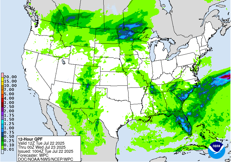
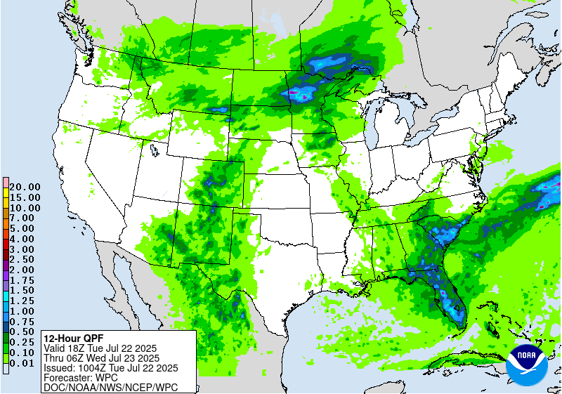
Valid 12Z Tue Jul 22 2025 - 12Z Wed Jul 23 2025
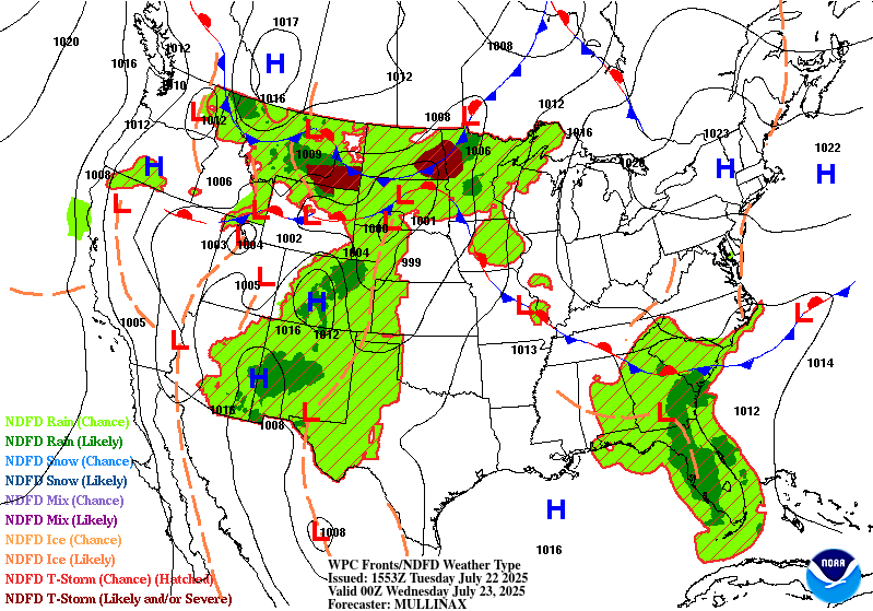
...THERE IS A SLIGHT RISK OF EXCESSIVE RAINFALL FOR PORTIONS OF
THE UPPER MISSISSIPPI VALLEY, SOUTHWEST AND SOUTHEAST...
..Northern Plains/Upper Midwest...
Regional radar mosaic across the Northern Plains depicts a
migrating cluster of thunderstorms over the Dakotas with the proxy
of the convective complex along the ND/SD border. Mean storm
motions continue to point to the complex of thunderstorms migrating
east-northeast with heavy rainfall likely to be impacting portions
of eastern ND and far northeast SD into MN by the turn of the new
D1. This complex will likely draw some attention for flash flooding
by itself, but the environment will be somewhat favorable for the
first half of the D1, so the threat will likely be more isolated
with the best chance occurring in any urbanized settings. Majority
of this heavy precip will likely fall north of I-94 in MN with the
Minneapolis metro unlikely to see much of any impacts. The period
becomes more favorable for heavy rain prospects as we move into the
second half of the forecast as a stationary front currently
analyzed over IA/IL into SD will lift northward through the
afternoon with an appreciable advection of deep layer moisture
priming the environment for the following evening. Surface low over
the High Plains will slowly advance through SD during the forecast
period with a cold front dropping steadily out of Canada with eyes
on the Upper Midwest by the end of the D1. The proxy of the warm
front and advancing cold front will lead to a tight window of
enhanced sfc-850mb convergence within a formidable pool of moist,
unstable air positioned across the eastern Dakotas through much of
MN/WI. PWATs between +2 and +3 deviations will be present over the
aforementioned areas with values >2" likely as we move beyond 00z
Wed. LLJ initiation across the Upper Mississippi Valley will help
trigger an area of heavy convection across the Dakotas which will
eventually migrate eastward through the Red River basin into the
northern half of MN.
As of this juncture, the greatest threat for heavy rainfall >2" is
likely over southeast ND, far northeast SD, and adjacent areas of
northwestern MN with an eastward expansion over the central portion
of MN (St. Cloud area). 00z HREF and REFS neighborhood
probabilities for >2" are between 80-90+% for these locations with
>3" (60-80%) and >5" (20-35%) well within a reasonable depiction
for a widespread flash flood threat in that area of the northern
CONUS. HREF EAS probabilities for >1" are also robust with 70-90%
for >1" and 40-60% for >2" situated over those same areas, a
testament to the growing consensus within the CAMs window as we
move closer to the event. This aligns very well with the EC AIFS
Ensemble mean QPF output of 1.25-1.5" in that corridor, a very
strong output when you take into account the traditional low bias
from the AIFS in general.
The FFG's located across central MN are small deterrent for any
appreciable risk upgrades as the threat targets places where
1/3/6hr indices remain a little high compared to areas a bit
downstream and further south. Despite those indices, multiple flash
flood warnings are increasingly likely over southeast ND, northeast
SD, and central MN as we step through the evening, especially with
a growing threat of training and back-building as proposed by the
weakening Corfidi Upshear vectors in the CAMs as we move into the
evening. This makes sense as the mean flow becomes parallel to the
boundary with the approach of the front to the north.
There is some chance this setup nudges north as the mid-level ridge
to the south will truly flex and the warm front progression should
migrate pretty rapidly to the north through the afternoon and
evening, especially with the added nose of LLJ structure positioned
to the south. Where this ends up is the ultimate delineation point
of where training could occur and have the highest prospects for
flash flooding. For now, a high end SLGT is forecast over that
corridor positioned over ND/SD/northwest MN with an eastward
extension through central MN prior to the Arrowhead. Pending
forward propagation speed of the nocturnal convection, the risk
could evolve further downstream prior to the end of the D1 period,
so it will be something we will monitor closely. In any case, the
SLGT risk still runs through portions of the Arrowhead into
northwestern WI back into those favorable areas to the west.
...Southeast...
Elevated PWATs and instability across the Southeastern CONUS will
maintain a posture of widely scattered thunderstorms capable of
locally enhanced rainfall rates between 2-4"/hr that could spur
flash flood prospects through the course of the daytime hrs. A
weak surface reflection along the SC coast with a weak quasi-
stationary front aligned west to east across the Southeast will
lead to enhanced regional convergence that could allow for slow-
moving heavy thunderstorms to train over any area in proxy to these
features for a few hrs. These are the types of setups that can
provide a sneaky 4-7" maxima in any given location, especially
near the low pressure center along the Carolina coastal plain.
Surface trough extending off the southern flank of the low will
bisect southeast GA down through northern FL with guidance
consistently pinning a more defined heavy precip axis within the
confines of this area. FFG's remain very high across that specific
area, so the threat for widespread flash flooding is very low,
especially when considering the probabilities for >5" are still
running <25% for a majority of that region, a signal necessary for
more appreciable impacts to occur in these zones. 00z HREF
neighborhood probs for >5" are higher than previous forecasts for
the coastal Carolina's with the max probs (30-45%) located from
Morehead City, NC down through Charleston, SC. Multiple population
centers are encompassed in that zone, the most likely locations to
see any flash flood prospects due to urbanization factors. EAS
probabilities for >1" are also pretty elevated over the Upper SC
coast (>50%) with a modest output over the area referenced above.
The synoptic and thermodynamic evolution support a strong coastal
convergence pattern, especially with the afternoon sea breeze
during the life cycle of the surface low, so the upgrade to SLGT
from the last forecast update maintains merit. Considering the
current signals, there was no reason to deviate from the previous
forecast, so the SLGT risk remains due to continuity.
...Southwest...
Another period of monsoonal type convection will enhance localized
flash flood prospects across eastern AZ and much of NM/CO.
Persistent moisture advection along the western flank of a ridge
positioned across the Mississippi Valley will be the driver for the
threat as scattered to widespread showers and thunderstorms will
litter the Southwestern CONUS up into the Central Rockies by
this afternoon, carrying through the evening hrs. Any area within
the confines of the above regions will have a threat for impacts
due to convective cores likely producing rates >1"/hr with upwards
of 2"/hr in the strongest cells. Areal QPF average is generally
between 0.25-0.75", but neighborhood probabilities for >1" over
eastern AZ into NM/CO are well above 70% with >2" probs running
between 40-70% over the more terrain favored areas in both
locations. The most prominent signal for rainfall eclipsing 1"
aligns within the Sangre de Cristos and the eastern side of the
Mogollon Rim near the AZ/NM line. These are the most likely
locations to see heavy rainfall and heightened flash flood
prospects this period with the best chances over any remnant burn
scars. Mean storm motions will be generally weak, so any convective
cores will run the chance of impacting the same areas for multiple
hours before collapsing or moving away from their initiation
points. A broad SLGT risk encompasses much of NM, southwest TX, and
southeast AZ with a bit of an extension into CO along the Sangre de
Cristos.
Kleebauer
Day 1 threat area:
www.wpc.ncep.noaa.gov/qpf/94epoints.txt
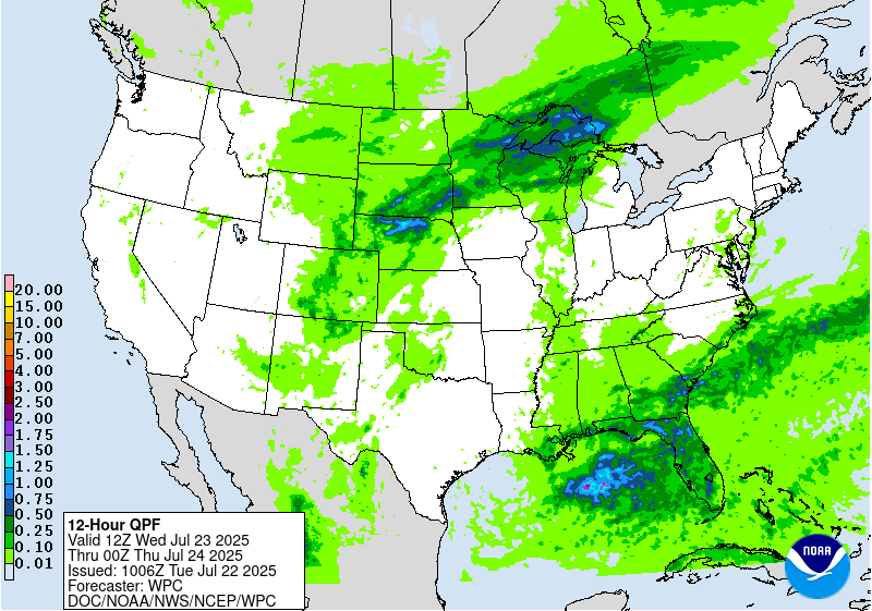
Excessive Rainfall Discussion
NWS Weather Prediction Center College Park MD
409 AM EDT Tue Jul 22 2025
Day 2
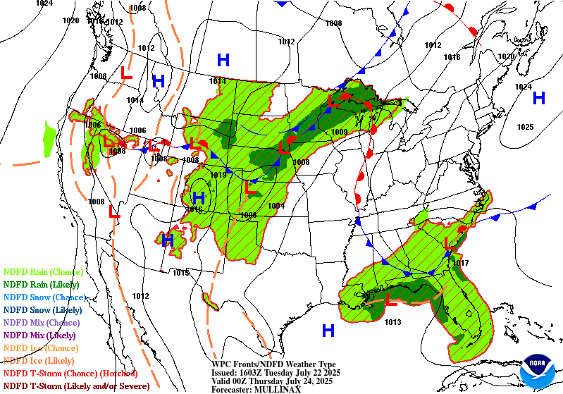
Valid 12Z Wed Jul 23 2025 - 12Z Thu Jul 24 2025
...THERE IS A SLIGHT RISK OF EXCESSIVE RAINFALL OVER PORTIONS OF
MINNESOTA, NORTHERN WISCONSIN, AND THE WESTERN U.P. OF MICHIGAN...
...Upper Midwest...
The progression of convection from the prior D2 will bleed over
into the front half of D3 with the cold front slowly migrating
eastward allowing some advancement of the organized convective
pattern to spill over into the Arrowhead of MN and adjacent
northern WI and western U.P. There's a better consensus on this
occurring given the aligning mass fields from relevant
deterministic, as well as an agreement on the pattern progression
as the surface low over the northern plains finally lifts northeast
along the front and clears into the northern lakes by Wednesday
afternoon. The final 12hrs of the HREF blended mean QPF output was
pretty clear in a heavy precip presentation across northern WI
through the U.P with the focus likely along and south of the
southern lake shores of Superior. Deterministic depictions are
upwards of 2-4" in additional QPF spilling over from the previous
forecast period leading to some 24hr totals from 00z Wed to 00z Thu
running upwards of 4-5" over the western U.P and northern WI. This
would entice the threat for flash flooding due to the anticipated
rates between 1-2"/hr with higher intra-hour rates expected given
the favorable environment of PWATs >2".
The cold front will still be slowly pushing eastward through the
second half of the period with guidance indicating another wave of
low pressure potentially enhancing the convective pattern across
the Upper Midwest as we move into Wednesday evening. There's a
growing consensus on heavy precip redeveloping across the central
and northern plains between NE/SD and migrating east-northeast
along and ahead of the slow-moving cold front. With flow remaining
parallel to the boundary across a majority of the cold front
positioning, heavy convection with some back-building/training
evolutions are favored which would undoubtedly lead to, at least
some scattered flash flood concerns. The highest probabilities sit
firmly over northeast NE up through the southern half of MN where
ensembles delineate the most favorable proxy of the cold front. QPF
means are running between 1-2" from Minneapolis down towards Omaha
with the prob fields off the latest ECENS and EC AIFS Ensemble
depicting the highest threat across southwest MN towards
Minneapolis with the second round of convection. This was enough to
extend the previous SLGT risk further to the southwest to cover for
the threat with even some potential for extend further back into NE
if the consensus grows and/or magnitudes of rainfall increase
further. This window (00-12z Thu) will need to be monitored
closely.
...Southeast...
A slowly westward migrating upper trough off the Southeast coast
and attendant surface low over the northern Gulf will lead to
locally heavy rainfall prospects from the central Gulf coast over
into Florida. The signal for rainfall exceeding 3" remains very
spotty within the varying deterministic, however the threat remains
for isolated heavy convection anywhere along the South Carolina
coast down through the northern half of the FL peninsula over into
the central Gulf coast. Overall, the threat remains on the lower
end of the MRGL risk category, but environment and proximity of
favorable surface pattern maintains the threat for a few robust
cells that could easily overproduce with PWAT forecasts firmly
above 2.25" with some of the coastal plain likely to see PWATs
exceeding 2.5" at times.
...Central and Southern Rockies...
Ample moisture, instability and weak mid-level perturbations in
proximity to the Continental Divide will lead to slow-moving bouts
of convection that will amplify heavy rain prospects that could
induce flash flooding. Terrain complexity and the slow-moving
nature suited by lackluster mean flow and cell anchoring over the
topography spell for a sneaky flash flood risk across the central
and southern Rockies with a general maxima positioned across CO,
west of I-25. A MRGL risk exists for the threat, but if signals
within the CAMs continue to grow as we move closer to the threat
window, a targeted upgrade is not out of the question. For now,
have maintained continuity with the MRGL and will await for the 12z
CAMs output as they will have the full D2 output/prob fields to
assess for the threat.
Kleebauer
Day 2 threat area:
www.wpc.ncep.noaa.gov/qpf/98epoints.txt
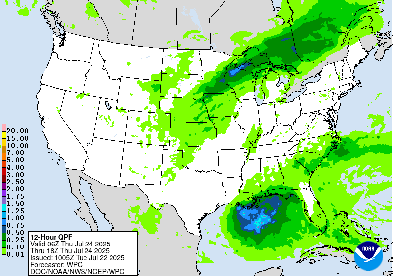
Excessive Rainfall Discussion
NWS Weather Prediction Center College Park MD
409 AM EDT Tue Jul 22 2025
Day 3
Valid 12Z Thu Jul 24 2025 - 12Z Fri Jul 25 2025
...THERE IS A MARGINAL RISK OF EXCESSIVE RAINFALL PORTIONS OF THE
CENTRAL AND HIGH PLAINS, MIDWEST, AND SOUTHEASTERN U.S...
...Central Plains to Great Lakes...
Cold front progression and sheared mid-level shortwave ejecting out
of the Rockies will become an integral part in enhancing regional
convective output from the Central Plains up through the Great
Lakes. The environmental parameters such as favorable
thermodynamic properties (Elevated MUCAPE), weak mid-level forcing,
and sfc-850mb convergence in correlation to the front will provide
enough of a mechanism to drive scattered to widespread areas of
thunderstorm activity capable of producing localized flash
flooding. Good news is the models have the threat in question. The
bad news is the consensus on where is pretty much up in the air.
The most favorable areas in the ensemble means are across the
central Midwest back into the Central Plains with a secondary
maxima focused across the Great Lakes. The prospects for a SLGT are
relatively high within the bounds of the broad MRGL risk, but the
threat for scattered flash flood concerns is very much warranted
with the signal.
...High Plains...
Another closed low off CA will allow for a broad diffluent mid and
upper level regime with a multitude of smaller shortwaves migrating
northeast out of the Four Corners. Scattered convective pulses will
likely transpire over the Front Range down along the Continental
Divide. Any area within these bounds could be subject to heavy
precip with a potpourri of individual deterministic outputs
signaling the threat for 2-3+" in any location. Not enough of an
organized area to produce anything more than a broad MRGL risk
encompassing the above areas, so maintained continuity from
previous forecast.
...Southeast...
Low pressure along the central Gulf coast will entice yet another
period of heavy convective potential from LA back into FL/GA. PWATs
remains very high (>2.25") for the period with ample instability
situated along the Gulf coast and areas just inland. This is a
prime setup for somewhere to see over 5" of rainfall in a spot, but
the question of exactly where is very much up in the air. Just
assessing the SLP positioning, the best threat is likely over
Southern LA, mainly along and south of I-10. This is a signal
within multiple global outputs, and coincides with the best
convergent winds on the northern side of any surface circulation.
In any case, still kept the previous MRGL inherited just due to the
lack of a discernible organized maxima, but don't be surprised to
see a targeted upgrade somewhere along the central Gulf coast as we
inch closer to the time frame of interest.
Kleebauer
Day 3 threat area:
www.wpc.ncep.noaa.gov/qpf/99epoints.txt
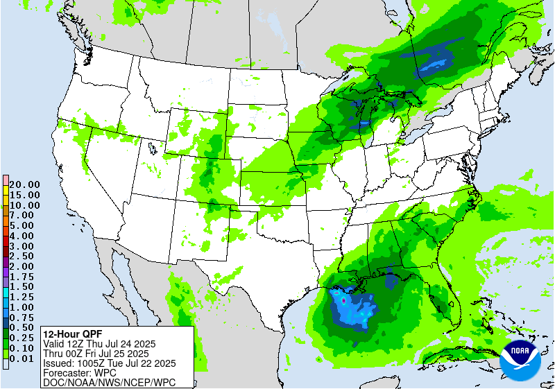
Extended Forecast Discussion
NWS Weather Prediction Center College Park MD
257 AM EDT Tue Jul 22 2025
A cold front is progged to slowly track towards the southeast
across the Great Lakes and New England for the end of the week,
with a weak wave of low pressure crossing southern Ontario. This
boundary will be intersecting a hot and humid airmass, and this is
expected to fuel the development of multiple thunderstorm
complexes from Iowa and Missouri eastward to the northern Ohio
Valley and much of the Northeast U.S. on Friday. A Marginal Risk
area is valid for Day 4/Friday for these regions since some of the
storms may have convective training, and thus increasing the risk
of localized flooding where this happens. The model signal for
heaviest QPF is most concentrated over central portions of Illinois
and Indiana, and there is a good chance parts of those states may
eventually need a Slight Risk as the event gets closer in time. By
Day 5/Saturday, the axis of heavier rainfall is a little to the
south across the central Ohio Valley and northern portions of the
Mid-Atlantic, and this is where the Day 5 Marginal Risk will be.
Another area of unsettled weather is expected to reside across the
Florida Panhandle and extending westward to southeast Texas on
Friday as well. A weak surface low is likely to form along a
lingering stationary front, and this should gradually track west
through Friday before dissipating on Saturday. The potential
exists for an inch or two of rainfall in localized cases from
southern Louisiana to the Florida Panhandle, and a Marginal Risk
area is valid for Friday to account for this. Across the Dakotas
and into western Minnesota, the next frontal boundary approaching
from central Canada will likely have enough moisture with it to
fuel the development of more showers and thunderstorms, some of
which may develop into complexes with multiple rounds of rainfall.
Therefore, a Marginal Risk area will be valid here for Friday and
lingering into Saturday.
The other big story will be the continuing heat and humidity across
a large portion of the east-central U.S. for the end of the week
and into next weekend, courtesy of a large upper high initially in
place over the Mid-South and Southeast. Heat Risk in the major
category will be prevalent from the Deep South to the Midwest and
extending eastward to include Tennessee and Ohio River Valleys to
close out the work week. Some of this heat will likely reach the
East Coast by Friday and Saturday with highs well into the 90s and
heat indices over 100 degrees. Highs in the 100-105 degree range
are likely from northern Texas to Kansas as the upper ridge becomes
re-established over this region by Sunday and early next week. It
will also be uncomfortably warm and humid at night, providing only
limited relief from the heat.
Hamrick


