Extended Forecast Discussion
NWS Weather Prediction Center College Park MD
310 AM EDT Sun Jul 27 2025
...Dangerous heat wave persists in the Southeast through midweek
with gradual relief later week...
...Heavy rain and flash flooding potential in the central
Plains for multiple days...
...Overview...
By the start of the medium range period midweek, the sprawling
upper high atop much of the U.S. early this week will be weakening
somewhat and be pressed south by a northern stream upper trough.
Dangerous heat is possible across the Lower Ohio/Tennessee Valleys
and Mid-Atlantic Wednesday before a cold frontal passage tied to
the upper trough, while the Southeast is forecast to see the heat
continue into late week but gradually shrink in scope. Complexes of
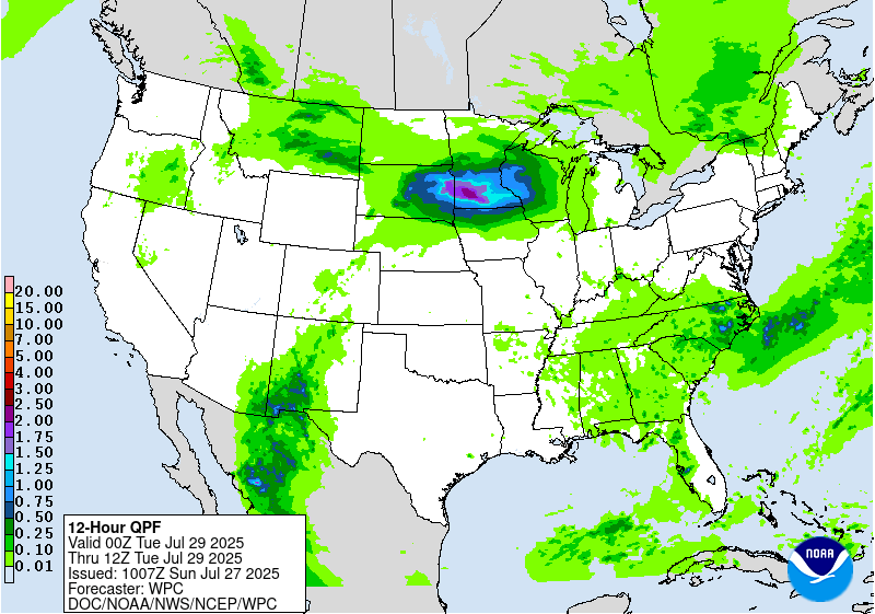
showers and storms are likely near and ahead of the frontal system
stretching from the High Plains eastward across the central
Plains/Mid-Mississippi Valley into the Northeast Wednesday. The
front is likely to stall near the central Plains and lead to
multiple days of storms with heavy rain that could cause flash
flooding. Farther east the cold front should be more progressive,
making its way southward across the Mid-Atlantic and Southeast but
creating an environment for possibly heavy rain each day as it
moves. Meanwhile, southerly flow will bring monsoonal moisture into
the Southwest states for possibly heavy rain.
...Guidance/Predictability Assessment...
Model agreement is excellent for the overall pattern through late
this week. Models have been persistent in showing the expansive
upper high shrinking in scope by Wednesday and becoming centered
over the southern Plains late week, with perhaps another
subtropical high moving across Florida. Meanwhile the ridge axis
will stretch north across the northern Rockies into western Canada
starting Tuesday, coincident with the upper trough edging into the
north-central to northeastern U.S. anchored by a large Hudson Bay
to eastern Canada upper low. Since model differences were mostly
negligible through late week, aside from the 12Z UKMET which showed
some differences in its handling of the ridge, used a 18Z GFS/12Z
ECMWF/12Z CMC blend for the first half of the forecast period.
Regardless of the large scale agreement, shortwaves riding around
the ridge will cause more differences in sensible weather like
frontal placement, and convection will have further uncertainties
due to small boundaries like outflows interacting. These tend not
to become clearer until the short range or near term, so the
details of QPF remain uncertain, but at least the overall pattern
seems set.
By next weekend, model differences start to increase as the
pattern becomes more quasi-zonal and uncertain shortwaves dominate
more. One larger scale model difference was the pattern in the
Northwest especially by next Sunday. This will be influenced by a
large Northeast Pacific upper low with somewhat uncertain
placement. The 12Z GFS was farthest southwest with the upper low
and did not allow for much troughing to come into the Northwest
compared to the non-NCEP guidance. AI/ML models are split but
leaned toward the Northwest troughing. Newer 00Z models have
trended east toward Southeast Alaska with the upper low, but still
have some differences with how much energy may split off this low
and when to create troughing in the West. Used some GEFS and EC
ensemble means by the latter part of the medium range to temper the
individual model differences by that time.
...Weather/Hazards Highlights...
Another hot day is forecast from the south-central U.S. into the
Southeast, Tennessee and Ohio Valleys, and much of the Eastern
Seaboard on Wednesday underneath the (albeit shrinking) upper high.
HeatRisk is mainly in the Major (level 3/4) category with some
embedded Extreme (level 4/4) areas with highs generally in the 90s
to near/exceeding 100 with higher heat indices, while morning lows
well into the 70s and nearing 80 will not provide much relief. A
few more daily records for temperatures could be set into
Wednesday. On Thursday, the cold front will pass through the Ohio
Valley to Mid-Atlantic and bring near to below normal temperatures,
with the heat wave becoming more limited to the
Southeast/Carolinas. The gradual movement of the front southward
should finally lead to heat relief in the Southeast Friday-
Saturday, though Florida could still be hot. Cooler than average
temperatures (especially highs) are likely in the northern/central
Plains on the cool side of the front and with the clouds and rain
chances.
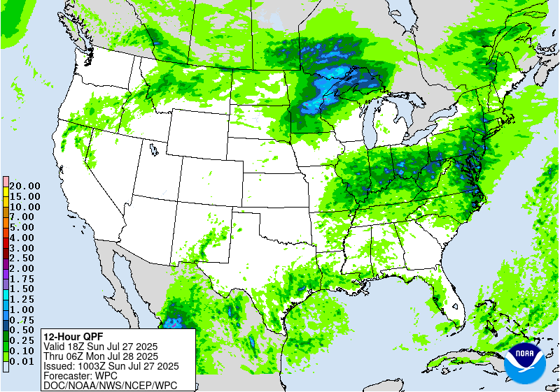
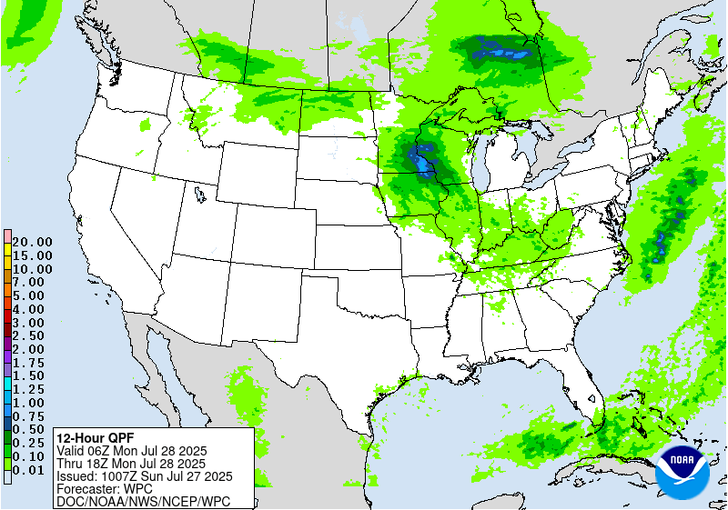
Rain and thunderstorms are forecast to focus on the periphery of
the ridge, enhanced by a frontal boundary across the northern
Rockies into the north-central Plains and Mississippi Valley. Some
shortwave forcing and above normal moisture and instability should
lead to multiple rounds of convection with high rain rates, and
some areas could see repeating rounds of storms with the front
stalling. Thus for the Day 4/Wednesday and Day 5/Thursday ERO, show
Slight Risks over the central Plains for the possibility of flash
flooding. On Day 4/Wednesday, also have the Slight Risk looping
east into the Middle Mississippi Valley where models show MCSs and
antecedent conditions are generally wet. Marginal Risks stretch
north into the northern Rockies/High Plains near the back end of
the front as much higher than average instability (per the Extreme
Forecast Index) is in place. Meanwhile the front extends farther
east across the Ohio Valley and Northeast on Wednesday, promoting
potentially heavier rain in a moisture-laden pre-frontal
environment coincident with areas that have seen well above normal
rainfall the past several weeks, allowing for a Marginal Risk in
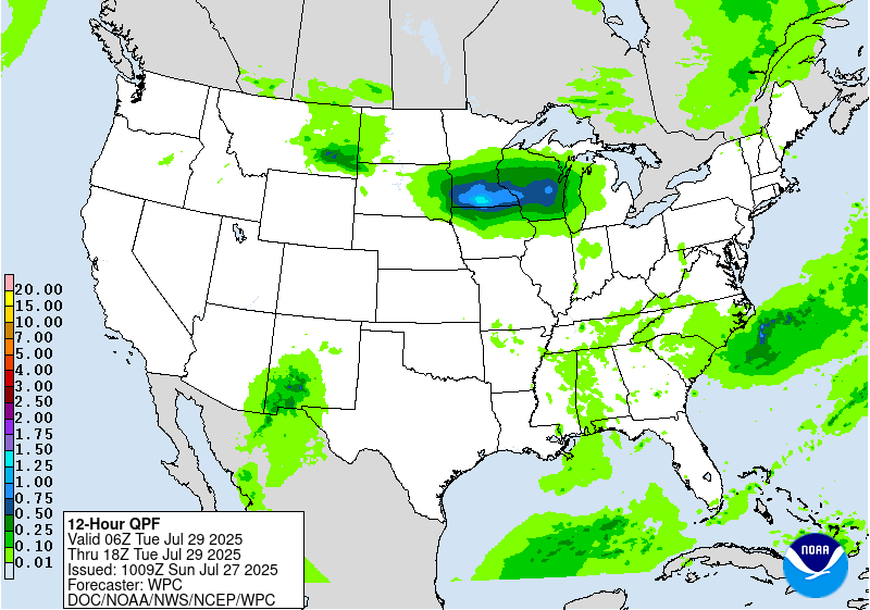
the Day 4/Wed ERO. By Thursday, the front will gradually move south
and lead to pooling moisture and instability in the Mid-Atlantic
along with increasing dynamical support in the form of the right
entrance region of the upper jet. Thus will show a Slight Risk in
the Day 5/Thu ERO for this activity. Enhanced rain is possible in
the Carolinas by Friday and Saturday near this front.
To the west of the ridge, monsoonal moisture (with precipitable
water values generally in the 75th-90th percentile) will be present
over the Southwest with some instability. Marginal Risks are in
place in the Days 4 and 5 EROs for the Southwest and reaching into
the central Rockies/High Plains as the monsoonal moisture meets the
frontal system to the north.
Elsewhere, moisture and instability could lead to scattered
thunderstorms in the southeastern U.S. from day to day. There may
be some focus for storms near the central Gulf Coast in particular
with weak low level troughs/lows in the vicinity. Marginal Risks of
flash flooding are in place for the central Gulf Coast and parts
of the Southeast due to high rain rates that may overcome the high
Flash Flood Guidance and/or fall atop urban areas.
Tate
Additional 3-7 Day Hazard information can be found on the WPC
medium range hazards outlook chart at:
https://www.wpc.ncep.noaa.gov/threats/threats.php
WPC medium range 500mb heights, surface systems, weather grids,
quantitative precipitation forecast (QPF), excessive rainfall
outlook (ERO), winter weather outlook (WWO) probabilities, heat
indices, and Key Messages can be accessed from:
https://www.wpc.ncep.noaa.gov/medr/5dayfcst500_wbg.gif
https://www.wpc.ncep.noaa.gov/medr/5dayfcst_wbg_conus.gif
https://www.wpc.ncep.noaa.gov/5km_grids/5km_gridsbody.html
https://www.wpc.ncep.noaa.gov/qpf/day4-7.shtml
https://www.wpc.ncep.noaa.gov/#page=ero
https://www.wpc.ncep.noaa.gov/wwd/pwpf_d47/pwpf_medr.php?day=4
https://www.wpc.ncep.noaa.gov/heat_index.shtml
https://www.wpc.ncep.noaa.gov/#page=ovw


