Excessive Rainfall Discussion
NWS Weather Prediction Center College Park MD
828 PM EDT Sat May 17 2025
Day 1
Valid 01Z Sun May 18 2025 - 12Z Sun May 18 2025
...THERE IS A MARGINAL RISK OF EXCESSIVE RAINFALL ACROSS PORTIONS
OF SOUTHERN PLAINS TO LOWER MISSISSIPPI VALLEY AND NEW ENGLAND...
...Southern Plains and Lower Mississippi Valley...
Convection across Northeast TX will continue motioning to the
east-northeast over the next several hrs., following an instability
tongue aligned south of a quasi-stationary front. Mean flow will
keep the storm cluster moving fairly progressively with sights on
Northern LA and Southern AR over the course of the overnight. LLJ
will initiate shortly providing a mechanism for sustaining current
convection, allowing it to trek all the way towards MS by 06-09z.
Storms will begin to lose their muster from there as LLJ across the
Southeast is much weaker, so the threat is expected to wane prior
to the end of the D1. Latest HRRR has had a good handle on the
convective setup with the primary axis of heavy precip aligned
within 40 miles north/south of the I-20 corridor which is where one
portion of the MRGL risk remains.
Two strong singular cells, one right-moving supercell and one
left-split supercell will enter similar spacing over the next hour
with a likely cold pool merger in-of Southeast OK. Guidance is not
as keen on maintaining a strong convective structure as the
influence of each other will act to cancel out with a weakening
pattern as we move further east. Prior, heavy rain will be situated
over the area between I-35 and I-30 creating a swath of heavy rain
in their respective paths. The positive in the cell motions are the
forward propagation speeds are relatively steady, so the flash
flood threat so far has been tamed with severe weather the primary
impacts from each cell since origin. Further west, a weak mid-level
perturbation will eject out of the TX Panhandle with mid-level
steering pattern sending energy due east through OK. Cells have
already materialized across the High Plains northeast of Amarillo
with an expectation of more cells to materialize as energy pivots
eastward and interacts with a 30-35kt LLJ structure over Central
OK. Pockets of up to 2" of rainfall are possible within a corridor
along and north of I-40 leading to isolated flash flood concerns
overnight. The previous MRGL risk was generally maintained from
last update to account for the setup.
...New England...
Slow-moving ULL over Ontario/Quebec will continue providing
significant forcing the next few hrs across Northern New England
with a line of thunderstorms motioning eastward through NH at this
hour. Pockets of 1-1.5"/hr rates could cause localized flash flood
concerns the next 2-3 hrs. before the threat fades as cells rotate
into Maine and eventually die off. Further south over Western MA, a
strong thunderstorm capable of rainfall rates between 1-2"/hr will
move east along I-90 with localized flood prospects until the cell
dissipates. This is more of a near term trend that has been
under-modeled in terms of intensity. The MRGL risk over Northern
New England was kept across Eastern VT through NH and Southwest ME
with an extension through North-Central MA to encompass the strong
thunderstorm occurring at this juncture.
Kleebauer
Day 1 threat area:
www.wpc.ncep.noaa.gov/qpf/94epoints.txt
Excessive Rainfall Discussion
NWS Weather Prediction Center College Park MD
828 PM EDT Sat May 17 2025
Day 2
Valid 12Z Sun May 18 2025 - 12Z Mon May 19 2025
...THERE IS SLIGHT RISK OF EXCESSIVE RAINFALL ACROSS PORTIONS OF THE
CENTRAL PLAINS INTO THE LOWER AND MIDDLE MISSISSIPPI VALLEY...
20Z Update: The overall synoptic pattern remains steady within the
run to run variance as the longwave evolution still indicates a
broad upper trough migrating east with large scale ascent
increasing over much of the Southern Plains to Mississippi Valley.
The northern extent of the convective threat and subsequent flash
flood concerns are still locked in as secondary surface reflection
over the Western High Plains will induce a regional axis of
sfc-700mb convergence with the best threat of convection aligned
within a defined theta_E ridge positioned over the Front Range up
through south-central MT. Slower storm motions and terrain
influences from local topography within the Big Horns will lead to
general training with heavier convective cores likely within the
broad instability and low-level ascent pattern. 12z HREF
neighborhood probs for >2" is between 30-60% over a large area
between the northwest Sandhills up through Central MT, a signal
that is coincident with elevated flash flood concerns due to the
local topography and complex drainage in-of those mountains/hills.
A targeted SLGT was contemplated, but the coverage of heavy
convection and the current FFG exceedance probs for the region
above are still on the lower end with the best probabilities
aligned within the Big Horns up through the Crazy and Little/Big
Belt Mountains. The MRGL was sufficient for this update, but will
monitor trends for a potential upgrade in future updates.
Across the Southern Plains to Mid-Mississippi Valley, the threat is
largely influenced by the broad large scale evolution upstream
creating a significant diffluent pattern within a corridor of
elevated instability and deep moisture presence. As of the 12z
suite, the jury is still out on exactly how the more organized
convective scheme across the Central Plains and Mid-Mississippi
Valley will transpire with the general deterministic variance
positioning the threat from as far north as Northeast KS and
Southeast NE to as far south as Southern MO, a solid 200 mile
deviation from one member to the next. The CAMs suite provides a
little more favor in-between with the ML output sort of edging into
that corridor from Northeast Oklahoma up into Central MO.
Considering some overlap with the CAMs on the alignment, the threat
for flash flooding is likely highest in that general zone with a
margin of error within 50 miles in any direction. The SLGT given
the above information was relatively unchanged with a high-end SLGT
still focused over the region extending from Northeast KS to points
southeast with the southern edge over the Ozarks of AR/MO. A
targeted MDT risk is possible, but with still some discrepancy
in the exact placement of the expected MCS, the SLGT was
maintained.
The MRGL risk into the Southern Plains seems locked in as well
with a potential for a targeted SLGT pending any overlap with
convection that occurs tonight. The DFW metro is the main
population center of focus in this setup as convection fires
within a zone of very unstable air. Rates of 1-2"/hr will be
possible with forward propagation speeds another deterrent for an
upgrade at this time. The MRGL risk across New England was adjusted
a touch south to include some lingering convective concerns over
north-central VT/NH. Otherwise, the setup didn't offer any
significant run to run discrepancies.
Kleebauer
..Previous Discussions..
...Plains, MS Valley and Southeast...
A favorable pattern for widespread convection and heavy rainfall
on Sunday across the middle portion of the country. A longwave
trough and embedded shortwaves pushing eastward across the Rockies
and into the Plains will provide ascent over a broad region. The
frontal pattern will likely feature a developing low moving into
the High Plains of CO/NE, a warm or stationary front extending east
of this low across portions of OK/KS into MO/AR, and a dryline
across OK/TX. A large pool of instability is expected east of the
dryline and south of the stationary front, with values upwards of
4000-5000 j/kg. Some convection may be ongoing near the
warm/stationary front Sunday morning, but more robust development
is expected by Sunday afternoon into the overnight hours as
stronger forcing ejects into the Plains.
The main area of focus for flash flooding appears to be near the
aforementioned warm/stationary front where some training of convection
is probable. The overall expectation is that robust convective
development occurs along/ahead of the dryline over central OK/KS
during the afternoon hours. Strong deep layer southwesterly flow
will likely quickly push this activity northeastward towards the
warm/stationary front. Activity will likely grow upscale Sunday
evening into the overnight, potentially into an MCS, at which point
it should feel the impact of the strong southwesterly low level jet
and begin turning easterly and then southeasterly aligned with the
upwind Corfidi Vectors. As this process occurs some
training/backbuilding on the south/southwest extent is probable
resulting in a scattered flash flood threat.
The exact MCS location/track remains a bit uncertain. All but
certain that the 00z NAM is too far north, as its QPF evolution is
an outlier and does not align with pattern recognition. The GFS
and GEFS mean are also probably too far to the northeast, with the
aforementioned expected MCS propagation taking it on a farther
south track. The 00z Gem Reg and RRFS are very far south, tracking
across eastern OK into central/northern AR. This may be too far
south, but can not be ruled out as easily as the farther north NAM
can. The AIFS has a track record of pinpointing organized
convection location quite well, and the 00z AIFS favors northeast
OK into southeast KS and southwest MO. This also happens to
generally be the middle ground of the other available models, and
so does appear to represent the most likely outcome at this time.
Thus a higher end Slight risk will remain in place across this
corridor, where scattered flash flooding is expected. The Slight
risk area was cut back a bit on its northern extent and expanded
to the southwest into more of OK and AR to account for the southern
trend. Can not rule out additional southward shifts/expansion..but
for now think the Slight risk area represents the general region
of most concern well.
Another area of interest will be farther northwest into central and
western NE, closer to the low track. A multi-model signal exists
for a second QPF max over this area...which makes sense given what
should be impressive synoptic driven ascent and instability along
the stationary/occluded front. Considered expanding the Slight risk
into this area...but opted against that for now. This area remains
in severe to extreme drought and possible the rainfall max ends up
over the high FFG sand hills. But we will continue to monitor
trends and an additional focused Slight risk may eventually be
needed.
A localized flash flood risk also exists both along the dryline from
central TX into OK...and over the Southeast where a lingering
boundary and substantial instability will support heavy rainfall
with any storms that area able to develop.
...Northeast...
A Marginal risk continues over portions of northern New England on
Sunday as a deep layered low remains overhead. This will be the
3rd straight day of localized heavy rainfall, and thus some areas
may be more sensitive by this time. Generally thinking both
instability and moisture will be lower by Sunday, however cold air
aloft under the low will likely still support some heavier
convective cells and an isolated flash flood risk.
Chenard
Day 2 threat area:
www.wpc.ncep.noaa.gov/qpf/98epoints.txt
Excessive Rainfall Discussion
NWS Weather Prediction Center College Park MD
828 PM EDT Sat May 17 2025
Day 3
Valid 12Z Mon May 19 2025 - 12Z Tue May 20 2025
...THERE IS SLIGHT RISK OF EXCESSIVE RAINFALL ACROSS PORTIONS OF THE
CENTRAL PLAINS INTO THE LOWER AND MIDDLE MISSISSIPPI VALLEY...
20Z Update: The previous broad SLGT risk was generally maintained
with an expansion into portions of the western Ohio Valley given
the latest trends in a further east push of convection Monday night
into early Tuesday. The theme for D3 is broad convective pattern
meeting with wetter antecedent conditions come Monday evening. The
overwhelming consensus is the coverage of thunderstorms will be
vast with thunderstorm genesis likely from south-central TX all the
way up through the Missouri Valley. Two questions remain; where
will there be an intersection of heavy rainfall in successive days
that would exacerbate flash flood concerns, and what latitude will
there be an eventual MCS propagation? The jury is still out on
those specifics, but the easy signature to note is the available
moisture and instability with a sharpening dryline over the
Southern Plains and strong upper forcing coinciding within a very
large jet coupling between the occluded cyclone to the north and
the southern stream jet displaced just to the south. A large area
of heavy QPF is likely within that zone above creating a broad
coverage SLGT risk with higher end flash flood threats within the
coverage. A targeted MDT is more likely than not (Although not a
perfect slam dunk) considering the D2-3 tandem of heavy rainfall in
the same areas. The exact placement is subject to variability, so
the higher risk was not added on this update. Despite that, the
pattern is indicative of widespread flash flood concerns with some
locally significant flooding increasingly favored given the
evolving pattern. Stay tuned for future updates and potential
upgrades as we move closer.
Kleebauer
..Previous Discussion..
Another day of widespread heavy rainfall expected across the middle
portion of the country on Monday as the longwave trough and embedded
shortwave energy slowly moves eastward. It will likely be an active
day/night with a broad region where flash flooding will be possible.
A Slight risk stretches from northeast TX northward into southern IA.
The northern extent of the Slight risk will be close to or just
north of the stationary front extending east of the central Plains
low pressure. Strong forcing overrunning this boundary will likely
result in an expansive area of convection, with some
training/backbuilding possible. The southern portion of the Slight
risk is driven by initial dryline convective development, likely
enhanced by the eventual eastward acceleration of the cold front
south of the low. The convergence from the dryline, cold front and
lifting warm front will all aid in convective development. The
general stagnant nature of the frontal feature through much of the
day (both the warm/stationary front and dryline) support a
training/backbuilding convective threat.
Exactly where the focus of highest QPF ends up remains a bit of a
question, but generally anywhere within the Slight risk is in play.
There is some signal that the axis from northeast TX into southern
MO could actually see the most intense rates and greatest flash
flood potential, with both the 00z CMC and AIFS highlighting this
corridor. However ingredients will also be quite favorable farther
north into MO and southern IA as well (pending exact frontal
positioning) and thus both of these areas could end up seeing
training/backbuilding at some point Monday and/or Monday night.
Some of these areas will also likely see heavy rain on day 2 as
well, and so hydrologic conditions could be more sensitive by this
day 3 time frame. Thus do consider just about all of the Slight
risk as a higher end Slight at this time, and think areas of flash
flooding are likely. It seems possible (maybe even probable) that
an embedded MDT risk will eventually be needed somewhere within
the broad Slight risk area. However uncertainty in both the
convective details and hydrologic conditions (pending what rainfall
happens on day 1 and 2) leads to low confidence in any MDT risk
location at this time. Thus we will hold with a higher end Slight
and continue to monitor trends.
Chenard
Day 3 threat area:
www.wpc.ncep.noaa.gov/qpf/99epoints.txt
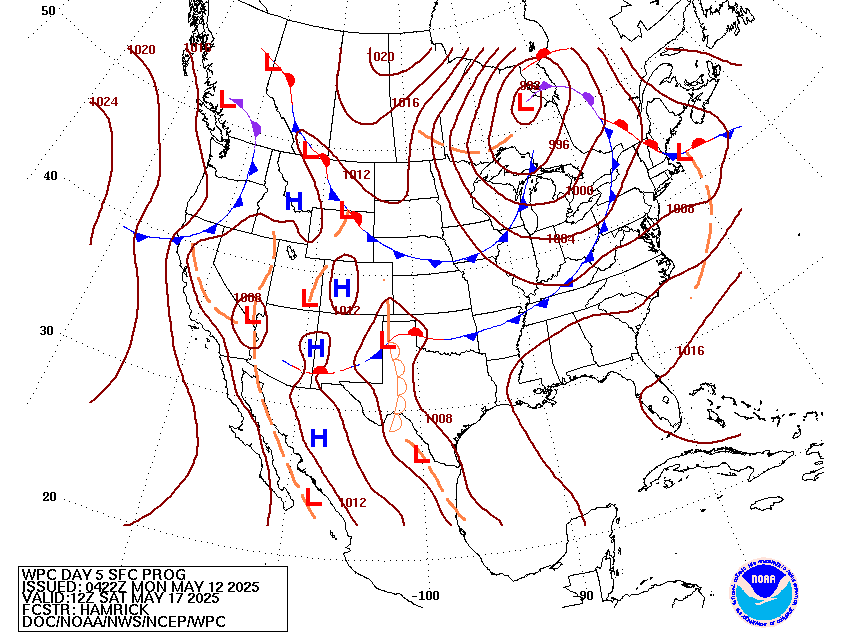
Extended Forecast Discussion
NWS Weather Prediction Center College Park MD
317 PM EDT Sat May 17 2025
Ample moisture and instability over the Miss/OH valleys Tuesday
ahead of a deep low over the east-central Plains along with strong
dynamical lift aloft will lead to widespread rain and
thunderstorms and mesoscale convective systems into Tuesday night.
This covers a broad area including most of the TN/OH Valleys and
back across the Midwest through southern MN where a broad Day 4
Slight Risk ERO remains with only minor edits to the shape. The
severe
weather threat area is focused over the southern portions of this
precip area in the warm sector over the TN Valley per the Storm
Prediction Center Day 4 Convective Outlook.
Rain and thunderstorm potential shifts east over the Appalachians
Wednesday as the low tracks east. Locally heavy rainfall is
possible particularly for the Mid- Atlantic region on Wednesday
where a Day 5 Marginal ERO remains. There is better agreement on
the Day 5 precip area today, but the overall magnitude seems to be
the greatest reason to not upgrade to a Slight Risk at time. Rain
chances will make their way into the Northeast Thursday-Friday as
the surface low pivots northward.
Elsewhere, some weak troughing aloft and frontal systems tracking
through the Northwest next week could produce rounds of modest
precipitation there. Most precipitation should be rain aside from
the highest peaks. Some rain may eject into the northern High
Plains by Thursday, with possibly another round of storms emerging
in the central U.S. by Friday, but with quite a bit of uncertainty.
Heat lingers over south Texas and the Florida Panhandle through
Tuesday, but the suppressed ridge should bring some temperature
relief by Wednesday. The trough/low aloft will promote below
normal temperatures across the northern tier with 10 to 15 degree
below normal temperatures working east mid to late week.
Upper ridging over southwestern U.S. will raise temperatures to
above normal there by Wednesday, expanding east across the Four
Corners states by Thursday and into the southern Plains late in
the
week. Highs will be well into the 100s in the Desert Southwest with
temperatures nearing 100 again in parts of Texas eventually.
Jackson
