Excessive Rainfall Discussion
NWS Weather Prediction Center College Park MD
1156 AM EDT Fri Jun 6 2025
Day 1
Valid 16Z Fri Jun 06 2025 - 12Z Sat Jun 07 2025
...THERE IS A SLIGHT RISK OF EXCESSIVE RAINFALL FOR PORTIONS OF
THE SOUTHERN PLAINS, THE LOWER OHIO, LOWER TENNESSEE AND MIDDLE
MISSISSIPPI VALLEYS AND NEW ENGLAND...
16Z Update...
Prior discussion remains valid outside of a few changes based on
morning guidance. Overall, a stationary boundary stretching over
2000 miles from the Northeast to the Southwest will provide a focus
for numerous convective complexes of varying size and magnitude.
Widely scattered instances of flash flooding can be expected with
the potential for locally considerable impacts.
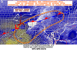
A SLGT risk was added for the LUB CWA in western TX along with the
expanded MRGL along the dry line to the TX Big Bend. Similar setup
to yesterday is expected to compound the potential for isolated to
scattered flash flooding, particularly if developing HP supercells
this afternoon impact urban regions with 2-5" totals.
Additionally, the SLGT risk across New England was expanded a bit
based on current radar and satellite trends showing a shortwave
passing over the Interior Northeast that will help spark
thunderstorm activity along an east- west oriented stationary front
extending through southern New England into central PA. 12Z HREF
and most 12Z CAMs are particularly impressive with the high-end
potential over NH given slow-moving convection initiating off the
higher elevations. 12Z HREF probabilities for greater than 5" are
as high as 25% across parts of NH.
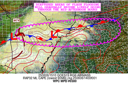
For the Ohio and Tennessee valleys, the SLGT risk was expanded
eastward into eastern KY based on latest radar trends as a potent
MCV over southern MO riding along the stationary front draped over
the Ohio Valley. See MPD 308 for more information. 12Z HREF was not
overly impressive in magnitude across this region for 2"+ amounts,
but coverage is expected to widespread enough to lead to scattered
instances of flash flooding.
Snell
Previous Discussion...
...South-Central Plains.....
There is a strong model signal for another round of organized
convection late Friday afternoon into Friday night/early hours of
Saturday across the south-central plains as additional shortwave
energy is forecast to drop east southeastward from the Central
Rockies into the Central to Southern Plains Friday into Friday
night/early Saturday. The low level flow is expected to again
strengthen into the west to east oriented frontal zone across the
Southern Plains, supporting potential for another round of
organized convection in the vicinity of this front. PW values
along this front will remain above average...2+ standard deviations
above the mean, supporting heavy precip potential. There is fairly
good model consensus for an axis of heavy rains along this front
from far southeast CO/far southwest KS, across much of OK into the
OK/KS/MO/AR border region. The slight risk was drawn to fit the
axis of the highest HREF neighborhood probabilities for 2"+ amounts
and the HREF EAS axis of highest probabilities for 1"+ amounts. The
next round of organized convection will likely track along the same
areas that are currently receiving heavy rainfall late Thursday
evening into early Friday for northern OK, compounding the
potential flash flooding concerns and leading to the potential for
more widespread and considerable impacts overnight.
...Mid Mississippi Valley, Lower Ohio Valley, Lower Tennessee
Valley...
The lead area of shortwave energy initiating current early morning
convection across the Southern Plains will be pushing toward the
Mid Mississippi Valley, Lower Ohio and Lower Tennessee Valleys
Friday afternoon/evening. Similar to areas upstream along the west
to east oriented frontal zone that extends into the Mid MS, Lower
OH,Lower TN Valley, PW values will be above average, 2+ standard
deviations above the mean. Convection likely to enhance Friday
afternoon/evening ahead of these height falls in the much above
average PW axis, supporting heavy rain potential and localized
flooding issues. A slight risk area was added from the previous
issuance, aligned with where the axis of the highest HREF
neighborhood probabilities for 2"+ amounts and the HREF EAS axis of
highest probabilities for 1"+ amounts are forecast.
...Southern Great Basin into the Central to Southern Rockies...
Not a lot of changes expected to the large scale flow across the
southern Great Basin into the Central Rockies. PW values forecast
to remain above average with additional shortwave energy moving
across the region in the west south west flow aloft. This should
support another day of widespread scattered convection and
localized heavy rain and isolated runoff issues. No significant
changes made to the previous marginal risk area across this region.
...East-central New York into Central New England...
A slight risk area was added for portions of east-central New York
State into central New England from central to southern New
Hampshire, across southeast Vermont, western Massachusetts into
east central NY state. There is good agreement in the last hi res
guidance for enhancing convection in the 1800 UTC Friday to 0000
UTC Saturday period in the axis of above average PW values along
the slow moving frontal boundary draped across this area. The
slight risk was drawn to fit where the axis of high HREF
neighborhood probabilities are for 2 & 3"+ totals. This corresponds
also to where the HREF hourly probabilities for 1"+ totals are
high in the 1800 UTC Friday to 0000 UTC Saturday period.
Oravec
Day 1 threat area:
www.wpc.ncep.noaa.gov/qpf/94epoints.txt
Excessive Rainfall Discussion
NWS Weather Prediction Center College Park MD
1156 AM EDT Fri Jun 6 2025
Day 2
Valid 12Z Sat Jun 07 2025 - 12Z Sun Jun 08 2025
...THERE IS A SLIGHT RISK OF EXCESSIVE RAINFALL ACROSS THE LOWER
ARKANSAS VALLEY, LOWER MISSISSIPPI VALLEY INTO THE LOWER TENNESSEE
VALLEY...
...Lower Arkansas, Lower Mississippi and Lower Tennessee Valleys..
The second round of height falls moving into the Central to
Southern Plains day 1 will continue to push east southeast toward
the Mid to Lower MS Valley, OH and TN Valleys during day 2. Upper
difluence is forecast to be well defined Saturday into Saturday
night/early Sunday in an axis of above average PW values that will
remain along the west to east oriented frontal boundary across
these areas. This should support potential for another round of
organized convection along this front. There is some spread with
the qpf axes, but consensus that heavy amounts are possible along
this front. The slight risk area was extended approximately 50m to
100 miles farther to the southeast across northern MS and northern
AL to cover the current model spread.
...East central NY State into Central to Northern New England...
Another round of convection possible early day 2 along the frontal
boundary pushing through the northeast as a sharpening northern
stream trof pushes eastward across northern NY into New England.
The HREF neighborhood probabilities for the 12 hour period from
1200 UTC Saturday to 0000 UTC Sunday, are high along this front for
1 and 2"+ amounts. The previous marginal risk area was extended
farther west into east central NY state to cover these higher 12
hour probabilities. There may need to be an upgrade to the risk
level in future issuances depending upon where the heavy rains
occur during day 1.
Oravec
Day 2 threat area:
www.wpc.ncep.noaa.gov/qpf/98epoints.txt
Excessive Rainfall Discussion
NWS Weather Prediction Center College Park MD
1156 AM EDT Fri Jun 6 2025
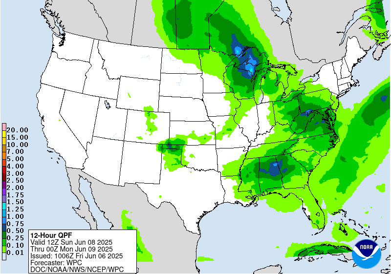
Day 3
Valid 12Z Sun Jun 08 2025 - 12Z Mon Jun 09 2025
...THERE IS A SLIGHT RISK OF EXCESSIVE RAINFALL ACROSS NORTH TEXAS
INTO SOUTHERN OKLAHOMA...
...North Texas/Southern Oklahoma...
Additional shortwave energy likely to push east southeastward late
Sunday afternoon/evening from the lee of the Central to Southern
Rockies into the Southern Plains. This will again re-strengthen
the low level flow into the west to east oriented front forecast to
remain across the Southern Plains, supporting another round of
organized convection along the front. There is fairly good
agreement on the day 3 qpf axes in the models. resulting in good
continuity with the slight risk area. The marginal risk area was
extended farther to the northwest into southeast Colorado to cover
the model qpf spread.
...Lower Mississippi Valley into the Southern-Central Appalachians
and Mid-Atlantic...
Broadly diffluent mid to upper level flow expected day 3 ahead of
the height falls pushing out of the Mid to Lower MS Valley, TN and
OH Valley region. With PW values expected to be above average...1.5
to 2+ standard deviations above the mean...widespread scattered
convection possible from the Lower MS Valley, across the Southern
to Central Appalachians and into the Mid-Atlantic. The previous
marginal risk area that was across the South was extended north
through the Southern to Central Appalachians and into the Mid-
Atlantic across the lower FFG values.
Oravec
Day 3 threat area:
www.wpc.ncep.noaa.gov/qpf/99epoints.txt


