Excessive Rainfall Discussion
NWS Weather Prediction Center College Park MD
817 PM EDT Sat Jul 12 2025
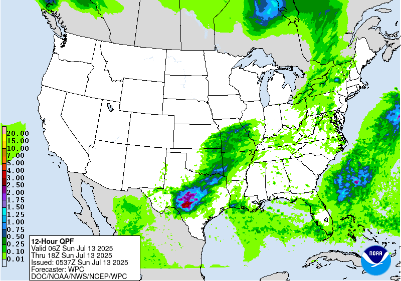
Day 1
Valid 01Z Sun Jul 13 2025 - 12Z Sun Jul 13 2025
...THERE IS A MODERATE RISK OF EXCESSIVE RAINFALL FOR PORTIONS OF
THE TEXAS HILL COUNTRY AND CONCHO VALLEY...
...New Mexico and the Southern Plains...
A sharp upper level trough is moving through the Southern High
Plains at the present time. An MCV is also apparent from daytime
convection across central TX, drifting eastward. Weaker shortwaves
aloft are moving up the east side of the sharp upper trough.
Overall, these features are expected to enhance lift/upper level
outflow across the Southern Plains and Arkansas.
Precipitable water values approach 2" across the region, roughly
0.50-0.75" below where they were 6-9 days ago, but more than
sufficient for heavy rainfall concerns due to the tall, skinny CAPE
within such saturated environments. ML CAPE across the region is
2000-3000 J/kg, which in southern portions of the risk areas
should be maintained by the low-level jet overnight.
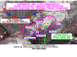
The TX Hill Country and Concho Valley are the primary concern.
Flash flood guidance values remain somewhat depressed by the heavy
rain event a week or so ago, and the 12z RRFS/18z HREF advertise
~30% of 8"+ in the 12 hour period ending at 12z. The last couple
Canadian Regional/HRRR runs advertise 10"+ during this time frame.
The available ingredients suggest that hourly rain amounts to 3"
with local amounts to 9" should be expected, and a new Moderate
Risk area has been added for this expectation, which has been
coordinated with the forecast offices in this region, particularly
EWX/New Braunfels TX and SJT/San Angelo TX where much of the new
Moderate Risk area lies. The first four hours of overnight
convective growth are the potential big rainfall problem, as it
could take that long for a cold pool to become established and
eventually lead to propagation to the east and southeast. Flashy
rivers like the Guadalupe should be avoided, if at all possible.
High Risk impacts cannot be ruled out locally.
...East of the Mississippi River...
Active convection will mostly tone down by midnight. Some activity
will linger in the vicinity of a mobile front across the Northeast.
The Marginal Risk in this region was left for these reasons.
Roth
Day 1 threat area:
www.wpc.ncep.noaa.gov/qpf/94epoints.txt
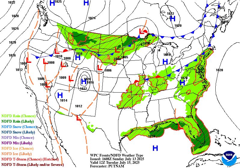
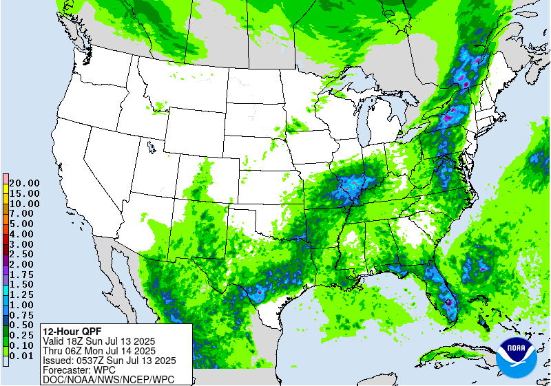
Excessive Rainfall Discussion
NWS Weather Prediction Center College Park MD
817 PM EDT Sat Jul 12 2025
Day 2
Valid 12Z Sun Jul 13 2025 - 12Z Mon Jul 14 2025
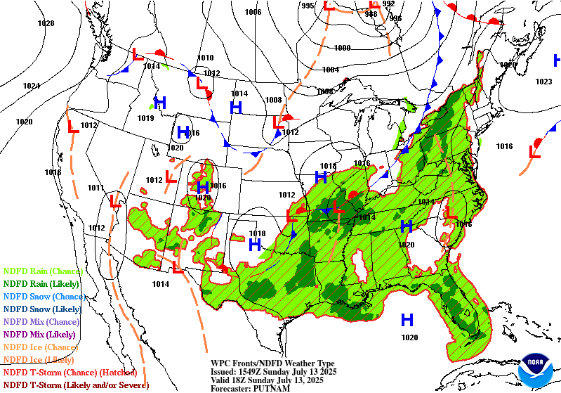
...THERE IS A SLIGHT RISK OF EXCESSIVE RAINFALL FOR PORTIONS OF NEW
MEXICO, THE SOUTHERN PLAINS, AND THE MID- ATLANTIC...
...Southern Plains...
The upper level shortwave responsible for forcing the thunderstorms
from Saturday night will cut off from the primary flow with the jet
on Sunday. This upper level shortwave will coincide with a
stationary front over Northwest Texas and Oklahoma. There will be a
continuous southerly flow of plentiful Gulf moisture across Texas
and Oklahoma on Sunday, but with limited forcing, the overall
coverage of showers and thunderstorms will be lesser on Sunday as
compared with today (Sat). The tradeoff in some areas with this
setup is because both the stationary front and upper level cutoff
disturbance will be very slow-moving, if moving at all, some of the
same areas that will likely see heavy rain from thunderstorms for
the second consecutive day. This is most likely in north-central
Texas and southeastern Oklahoma. For this reason, a higher end
Slight was maintained for this area on our internal progs. While
storm coverage will be lesser, due to the abundant moisture
available for any storms, the stronger storms will be capable of 2+
inch/hour rainfall rates, which will be heavy enough to cause
localized flash flooding over sensitive areas. Depending on the
rainfall pattern/amounts in this area today and the next cycle of
CAM guidance, a focused Moderate Risk area could be needed.
Farther west, combination of the frontal boundary and a slight
surge in moisture should combine for another round of scattered
storms which could lead to additional flash flooding across
sensitive areas. In coordination with WFO ABQ, added a Slight Risk
over central NM given the uptick in QPF compared to today (Sun).
...Mid-Atlantic...
Very few changes were needed to the Slight Risk that covers much of
the central Appalachians from Virginia north through upstate New
York. Abundant Gulf and Atlantic moisture will stream northward up
the East Coast through the period, increasing PWATs locally to
over 2 inches. A potent cold front will cross out of the Midwest
and into Pennsylvania and New York Sunday night. This forcing will
result in numerous showers and thunderstorms capable of very heavy
rainfall in the Slight Risk area. The greatest rainfall totals are
likely from northern Pennsylvania through central New York. Further
south towards and west of the DMV, while forcing will be lesser,
any storms that form will be capable of heavy rainfall with
abundant moisture available.
...Eastern Florida...
A mid-level feature (NHC is monitoring for potential tropical
development) off the Southeast Coast will drift southwestward then
westward toward the southern half of Florida tomorrow/tomorrow
night. With it, PW values will rise to over 2 inches (>90th
percentile) and some heavy rainfall is possible which could lead
to some flash flooding, especially over the urban areas.
Fracasso/Wegman
Day 2 threat area:
www.wpc.ncep.noaa.gov/qpf/98epoints.txt
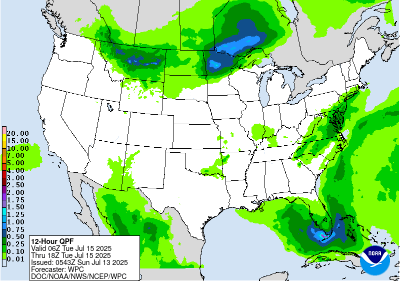
Excessive Rainfall Discussion
NWS Weather Prediction Center College Park MD
817 PM EDT Sat Jul 12 2025
Day 3
Valid 12Z Mon Jul 14 2025 - 12Z Tue Jul 15 2025
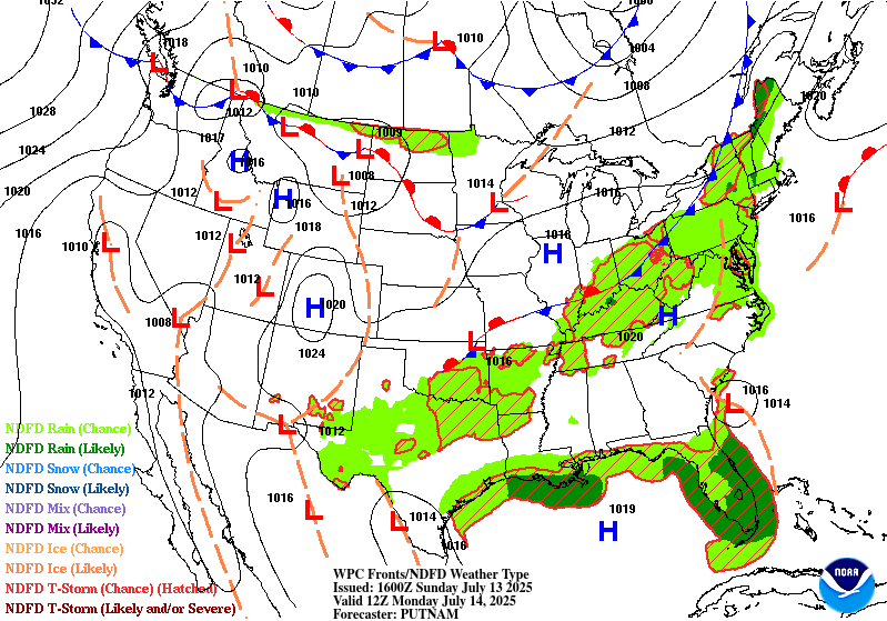
...THERE IS A SLIGHT RISK OF EXCESSIVE RAINFALL FOR MUCH OF THE
CENTRAL AND SOUTHERN FLORIDA PENINSULA...
...Florida...
The westward-moving mid-level wave will traverse the Florida
Peninsula on Monday, with an increase in PW values to over 2.25
inches (>95th percentile). The greatest rainfall and threat for
storms is expected during peak heating Monday afternoon coincident
with light winds in the lower half of the column. While there
remains considerable uncertainty as to convective evolution and
placement, the sheer volume of moisture available for any storms to
draw upon in the formation of heavy rain will be more than capable
of supporting heavy rain and resultant flash flooding. Much of
Florida has been dry for soil moisture and recent lack of rainfall,
so the drier than normal conditions will likely mitigate any
potential flash flooding. Urban areas such as the Miami-Ft
Lauderdale metro as well as Tampa and Orlando will be at a higher
risk for flash flooding due to the slow-moving storms, which will
likely interact via cold pools through the afternoon. Nudged the
Slight Risk southward to encapsulate the southern portion of the
Peninsula per coordination with WFO MFL.
...Southern New Mexico/Southeastern Arizona/Texas/Ozarks...
Weakening/dissipating front over northern Texas will become less of
a focus for rainfall, but there will still be lingering moisture
across the region. Maintained a broad Marginal Risk area over this
region as any additional rainfall over areas that may see several
inches of the next two days may cause a localized flash flooding
concern. Expanded the area westward into southeastern Arizona given
the expected surge in moisture from Mexico.
...East Coast...
Cold front will cross the Appalachians on Monday with another day
of scattered showers/storms ahead of the front. With PW values
remaining remaining above 1.75 inches (>90-95th percentile) and
rain from the previous two days, will continue a Marginal Risk
outline for this region.
...Northern Plains...
Frontal boundary across ND into MN will act as a focus for
scattered afternoon storms amid a increasing PW values to around
1.5 inches (~90th percentile). This could yield some 1"/hr rainfall
rates which may exceed local FFG values.
...Northwestern Montana...
Guidance indicates some modest rainfall moving into northwestern
Montana Monday afternoon/evening, which could capitalize on modest
instability present. Rainfall rates may not be too heavy but will
maintain the Marginal Risk in this region.
Fracasso/Wegman
Day 3 threat area:
www.wpc.ncep.noaa.gov/qpf/99epoints.txt
Extended Forecast Discussion
NWS Weather Prediction Center College Park MD
257 AM EDT Sun Jul 13 2025
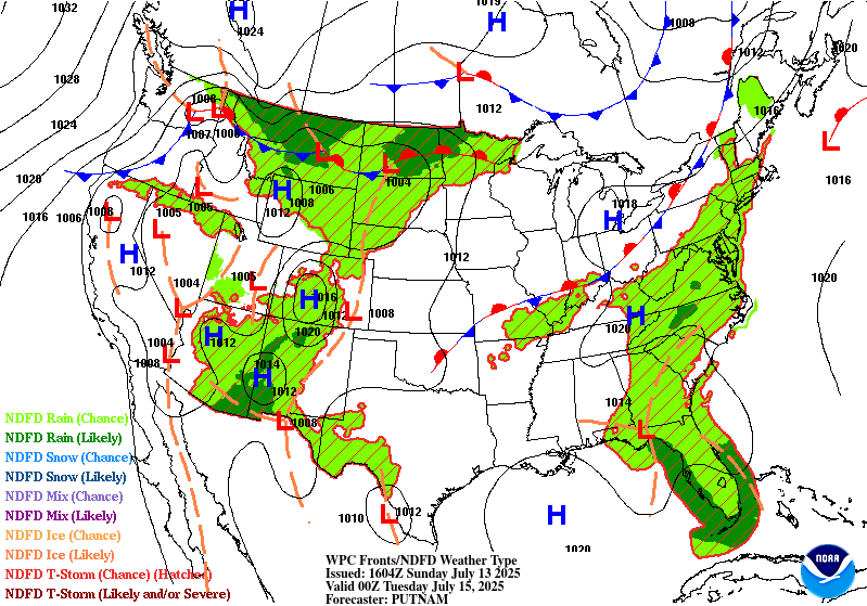
A surface low pressure system (which the National Hurricane Center
is now monitoring with low probabilities of tropical cyclone
development) will be retrograding across Florida into the Gulf by
mid-week. Moisture above the 90th percentile is likely to be in
place and promote multiple inches of rain in the Florida Peninsula
from Monday-Tuesday (short range period) into Wednesday. By The low
should be moving west into the Gulf by Thursday, but enhanced
moisture will remain in place across Florida, and spread into the
central Gulf Coast. A Marginal Risk is included on both the Day
4/Wednesday and Day 5/Thursday Excessive Rainfall Outlook/ERO for
those areas. Heavy rain may linger in the Gulf Coast region into
next weekend.
Much of the nation from the Rockies eastward will be active with
typical summertime convection in a warm and unstable airmass. A
cold front moving through the northern/central Plains and eastward
will support showers and thunderstorms with ample moisture and
instability, resulting in a heavy to excessive rainfall threat. The
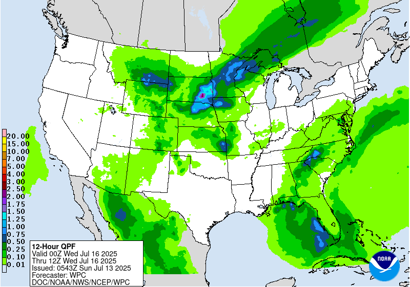
ERO on Wednesday shows a broad Marginal Risk area from the Upper
Midwest/Middle Mississippi Valley eastward into the Ohio Valley and
Central Appalachians. On Thursday, the marginal risk ERO shifts
more into the Ohio Valley/Mid-Atlantic and Northeast. Model
guidance varies considerably with placement of heavy rain amounts
on both days, so the Marginal is quite broad in order to cover the
widespread but low- end threat. Some areas may eventually need
embedded Slight Risks in future cycles if models converge on
placement and amounts of heavy rain.
Elsewhere, monsoonal moisture will gradually increase in coverage
across the Southwest/Four Corners/southern Rockies region. Marginal
risks are in place across southern Arizona, New Mexico, and points
north. More widespread monsoonal moisture will continue making its
way northward in this region through next weekend.
Hot weather may linger in the Pacific Northwest through around
midweek, but temperatures in the northern High Plains will cool
dramatically by Wednesday with highs around 15 to 25 degrees below
normal. Temperatures look to be a few degrees cooler than average
for the south-central U.S. for much of next week as clouds and rain
hold temperatures down. The Great Lakes and Northeast will see an
increase in heat next week with a building ridge over the region,
with somewhat widespread Major (level 3/4) HeatRisk showing up in
those areas mid-late week. Meanwhile the Southeast should be near
normal to a few degrees above, for typical summer heat and
humidity.
Santorelli
Extended Forecast Discussion
NWS Weather Prediction Center College Park MD
257 AM EDT Sun Jul 13 2025
A surface low pressure system (which the National Hurricane Center
is now monitoring with low probabilities of tropical cyclone
development) will be retrograding across Florida into the Gulf by
mid-week. Moisture above the 90th percentile is likely to be in
place and promote multiple inches of rain in the Florida Peninsula
from Monday-Tuesday (short range period) into Wednesday. By The low
should be moving west into the Gulf by Thursday, but enhanced
moisture will remain in place across Florida, and spread into the
central Gulf Coast. A Marginal Risk is included on both the Day
4/Wednesday and Day 5/Thursday Excessive Rainfall Outlook/ERO for
those areas. Heavy rain may linger in the Gulf Coast region into
next weekend.
Much of the nation from the Rockies eastward will be active with
typical summertime convection in a warm and unstable airmass. A
cold front moving through the northern/central Plains and eastward
will support showers and thunderstorms with ample moisture and
instability, resulting in a heavy to excessive rainfall threat. The
ERO on Wednesday shows a broad Marginal Risk area from the Upper
Midwest/Middle Mississippi Valley eastward into the Ohio Valley and
Central Appalachians. On Thursday, the marginal risk ERO shifts
more into the Ohio Valley/Mid-Atlantic and Northeast. Model
guidance varies considerably with placement of heavy rain amounts
on both days, so the Marginal is quite broad in order to cover the
widespread but low- end threat. Some areas may eventually need
embedded Slight Risks in future cycles if models converge on
placement and amounts of heavy rain.
Elsewhere, monsoonal moisture will gradually increase in coverage
across the Southwest/Four Corners/southern Rockies region. Marginal
risks are in place across southern Arizona, New Mexico, and points
north. More widespread monsoonal moisture will continue making its
way northward in this region through next weekend.
Hot weather may linger in the Pacific Northwest through around
midweek, but temperatures in the northern High Plains will cool
dramatically by Wednesday with highs around 15 to 25 degrees below
normal. Temperatures look to be a few degrees cooler than average
for the south-central U.S. for much of next week as clouds and rain
hold temperatures down. The Great Lakes and Northeast will see an
increase in heat next week with a building ridge over the region,
with somewhat widespread Major (level 3/4) HeatRisk showing up in
those areas mid-late week. Meanwhile the Southeast should be near
normal to a few degrees above, for typical summer heat and
humidity.
Santorelli


