Excessive Rainfall Discussion
NWS Weather Prediction Center College Park MD
850 PM EDT Fri Jul 11 2025
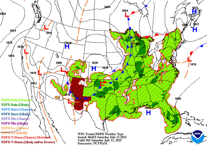
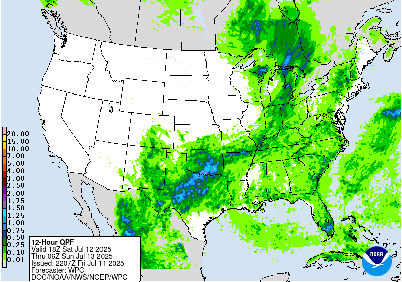
Day 1
Valid 01Z Sat Jul 12 2025 - 12Z Sat Jul 12 2025
...THERE IS A SLIGHT RISK OF EXCESSIVE RAINFALL FOR PORTIONS OF THE
MID AND UPPER MISSISSIPPI VALLEY AS WELL AS FOR PORTIONS OF THE
CENTRAL AND SOUTHERN HIGH PLAINS...
01Z Excessive Rainfall Discussion Update...
The Slight Risk areas that were inherited from the day shift
remained in place with few exceptions...the Slight risk area in
Iowa being one such area where some territory was removed given
the progression of the upper level forcing, Convection coming off
the Rockies has been fairly disorganized so far...but better
organization with a corresponding increase in the threat of heavy
to excessive rainfall should materialize later with the development
of a low level jet. Elsewhere...isolated convection should be
weakening/dissipating quickly with the loss of daytime heating.
Bann
Previous Excessive Rainfall Discussion...
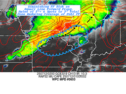
...Southern High Plains...
1852Z Update: In coordination with the local Amarillo WFO over the
Texas Panhandle, a targeted SLGT risk was added for this evening
as convection fires across Northeast NM and dives southeast as it
develops along the leading edge of a cold front and weak shortwave
reflection. Probs across the Panhandle remain relatively modest
with CAMs signaling the potential for ~3" of rainfall in any area
near the TX/NM border down through the Panhandle and northern
Caprock of TX. The best threat aligns within the nose of weak LLJ
positioned up near I-40. Despite drier soils encompassing the area,
this is a case where locally higher rates and flanking storms can
train and induce scattered bouts of flash flooding as the
convection migrates to the southeast. Best threat will be within
any urbanized settings, especially in and around Amarillo proper.
The SLGT risk extends just into the northern fringes of the TX
Caprock, mainly along I-87 south of Amarillo.
Kleebauer
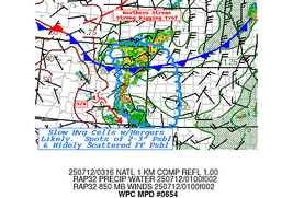
...Mid and Upper Mississippi Valley...
16Z Update: The overall evolution and anticipated flash flood
concerns were slightly changed from the previous forecast, but the
threat remains over much of the area outlined. There was some
shift in the heavier precip focus a bit further north into WI, a
lot to do with how the shortwave progression and a developing MCV
are handled as CAMs indicate a east-northeast motion out of IA this
evening leading to the primary vorticity exiting into southern WI
overnight. The proximity of the disturbance will play a critical
role in the strongest low-level convergence regime and flanking
convective development, so this is something that will need to be
monitored closely for near term adjustments. From a dynamical
standpoint, the setup makes sense as the regional amplification
expected can lead to disturbances gaining a bit more latitude,
thus shifting the focus a bit further north, at least on the
northern periphery of a shortwave. 12z HREF blended mean output
still puts the relative QPF maxima in-of the Quad Cities area of IA
with a strong consensus for heavy rain throughout much of WFO
Davenport's CWA as everything materializes. This is evident with
assessment of the latest HREF EAS prob fields for >2" signaling a
widespread 30-60% signal within the CWA bounds, so the threat for
elevated flash flooding prospects and a higher-end SLGT is
certainly in play over Eastern IA.
Neighborhood probabilities for >2 and >3" have increased across
southern WI, especially southwest WI along the US151 corridor from
the Mississippi river up near Madison. This adjustment is also
reflected into the Milwaukee metro, but not as pronounced compared
to area further south and west. As we move north, there's a growing
consensus for any meso-low or defined SLP center to occlude by the
end of the forecast cycle and shift focus for heavy precip along
the northern and northwest flank of the circulation. 12z CAMs were
pretty much in agreement on that type of evolution which can be a
sneaky way of getting a secondary maxima to crop up in the short
term. HREF prob fields are all over the threat as well with modest
(20-35%) probs for exceeding 3 and 6hr FFG intervals. Compared to
<10% for either probability in the 00z forecast, this is a pretty
stark shift in the potential, one that has enough merit to warrant
an expansion of the SLGT further north through WI where
probabilities are highest.
Further south into MO, trailing cold front will shift eastward with
the progression likely forming a broad area of deep layer flow
becoming increasingly uni-directional in-of the MO/KS border down
into northeastern OK. This was very well depicted in the RAP
925-700mb wind vectors with forecasted convection likely initiating
and situating southwest to northeast with cell motion along a
similar path. This could manufacture another area of locally heavy
rainfall capable of flash flooding. The greatest threat is likely
over southeast KS, southwest MO into northeast OK where the mean
wind is aligned best over an area where convection is expected
overnight. HREF neighborhood probs for >3" is now upwards of
25-45% with >2" probs over 60% across the aforementioned area. This
was enough to expand the previous SLGT risk further south to
account for the threat.
Kleebauer
..Previous Discussion..
A robust southwesterly low level jet streaming from the Plains into
the Mid-Mississippi Valley will provide a steady supply of Gulf
moisture into the region today. Meanwhile, a potent upper level
shortwave trough will approach this area from the west. The
combination of abundant moisture, instability, and forcing from the
shortwave will lead to numerous thunderstorms from northern
Missouri through eastern Iowa, northern Illinois, and far southern
Wisconsin, including the Chicagoland area. An MCS moving across
Iowa this morning will weaken in the morning daylight hours in
typical behavior for MCSs. Rainfall totals yesterday in the area
ranged from 1-4 inches, with the highest amounts across northern
Illinois west of Chicago. This rainfall has likely contributed to
saturating the soils in this area. Thus, the additional rainfall
forecast for this area should result in widely scattered flash
flooding. A higher-end Slight remains in place with only minor
changes from inherited, namely to trim up the southern end of the
Slight along the Kansas/Missouri border.
Showers and thunderstorms are likely to develop over central Iowa
as early as early this afternoon. As additional storms from in
northern Missouri, and track northeastward along the Mississippi
River, the potential for training storms will increase as the line
of showers and storms moves into northern Illinois. Backbuilding
may continue supporting additional thunderstorm formation as far
south as St. Louis this evening. This will likely allow the
potential for training storms to persist, increasing the flash
flooding threat.
Wegman
...Central High Plains...
16Z Update: Signal for locally heavy rainfall in-of an advancing
MCS out of the Front Range still remains elevated between the
triangle of Cheyenne/North Platte/Goodland with the best
probabilities for >2" positioning in the middle of these 3
population centers. Rates between 1-2"/hr for multiple hrs will
have the capability of localized flash flooding in the vicinity of
this region within the High Plains. 3 and 6hr FFG exceedance
probabilities remain steadily between 40-60% over the expected path
of the complex, enough to maintain general continuity of the
previous SLGT risk with only minor adjustments on the edges.
Kleebauer
..Previous Discussion..
As a strong shortwave trough digs southeastward across the northern
Plains, divergence at the base of the trough will increase the
lift, supporting storms across northeastern Colorado this afternoon
and evening. Meanwhile, typical leeside troughing will support
thunderstorm formation immediately downwind of the Front Range,
generally between Cheyenne and Denver along I-25. Storms may
initially form as early as 22Z/4pm MDT. As the storms move east off
the Front Range, they will encounter increasingly favorable lift
from the shortwave, as well as some Gulf moisture tracking
northward up the Plains. This will allow the storms to organize and
grow upscale in coverage and heavy rain potential. It is in this
region near the Colorado/Nebraska/Kansas tripoint which will have
the greatest threat for flash flooding with some limited potential
for training. With very low FFGs, especially across northeastern
Colorado (1-1.5 in/hr), a Slight Risk upgrade was hoisted with this
update. Some of the guidance suggests the storms will persist well
into tonight generally across far northwestern Kansas, so the
Slight Risk area includes that area as well.
Wegman
Day 1 threat area:
www.wpc.ncep.noaa.gov/qpf/94epoints.txt
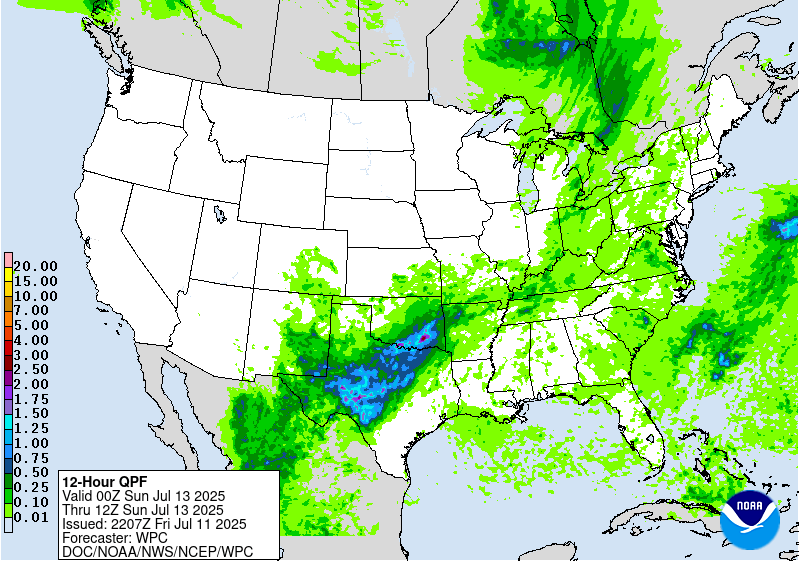
Excessive Rainfall Discussion
NWS Weather Prediction Center College Park MD
850 PM EDT Fri Jul 11 2025
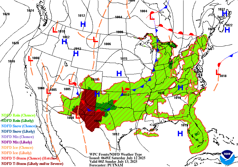
Day 2
Valid 12Z Sat Jul 12 2025 - 12Z Sun Jul 13 2025
...THERE IS A SLIGHT RISK OF EXCESSIVE RAINFALL FOR PORTIONS OF THE
SOUTHERN PLAINS...
Shortwave originating on the southern edge of mean troughiness and
upstream convection firing across Northeast NM into the TX
Panhandle will lead to a complex genesis of thunderstorms capable
of flash flooding, some significant over portions of North TX
through the Red River basin into OK. Biggest shift this forecast
was a faster progression of the overall synoptic evolution
coincident with a steadily moving cold front down the High Plains
of TX. Further east, the progression of the primary shortwave will
meet a bit more of a roadblock as the western periphery of a ridge
situated over the Southeast U.S. slows down the mid and upper level
progression enough to thwart much of an eastward advancement over
the second half of the forecast period. General destabilization
from diurnal heating and increased LLJ influence from surface low
positioned over the Southern Plains will lead to convective
initiation across North TX into OK by late-afternoon Saturday. This
will carry easily through the overnight hours as convergent areas
in-of the surface low/shortwave and areal cold pool convergence
lead to a broad scope of convective impact with some inference of a
complex forming somewhere in the confines of the Red River basin.
As a result, heavy rain with rates generally between 1-3"/hr will
develop and carry forward for several hrs. during the time frame of
interest leading to scattered, and perhaps widespread flash flood
prospects given the anticipated environment in place. Remnant
moisture from previous event the past week is filtered into the
soils, but left the top soil layer still leaning towards
saturation, especially as you work south of the Red River into TX
where several inches fell with the last convective outbreak.
Further south across the Permian Basin, Concho Valley, Edwards
Plateau, and adjacent Hill Country...the threat for scattered to
widespread convection is growing as the proximity of the cold front
and sheared mid-level energy over the region will generate a period
of convective development early Saturday evening with a
proliferation of thunderstorms likely to spur heavy rain concerns
over the aforementioned areas. There has been some inference within
the ML guidance in recent days that weighted a bit more on the
threat compared to the deterministic, but beginning to see the
deterministic, especially CAMs picking up on the threat brewing
over these locations. Cold front push latitudinally this time of
year tends to favor extensive convective development as it
interacts with LLJ enhancement over the Rio Grande into adjacent
areas of West TX. Convergence along and just ahead of the front
entice ample ascent, especially when coupled with diurnal
destabilization prior as noted by the mean 2000-3000 J/kg MUCAPE
forecast via the 12z HREF. Cold front will meet some push back as
it tries to lose latitude further overnight, but will eventually
hit a southern inflection point somewhere down into Hill Country.
This is also a climatologically favored evolution as cold fronts
struggle this time of year to advance further south in latitude due
to a multitude of factors.
QPF signals via the HREF blended mean and bias corrected ensemble
are pretty significant in their coverage of 2-4" areas with the
primary and secondary focuses aligned over North TX into OK along
the Red River basin to the north of DFW, as well as over the
Southern Permian Basin through the Concho Valley. The secondary
maxima is plausibly too far north when you take some inferred bias
of the FV3 and NAM Conest being much further north in the pattern,
dragging the mean further north in the overall output. EC AIFS
ensemble has been consistently a bit further south with the primary
centered over the Lower Trans Pecos into the Central and Southern
Concho Valley and portions of the Edwards Plateau. Some of the
higher QPF could sneak into Hill Country as well, but there will be
a pretty sharp cutoff on the southern flank of the QPF footprint as
everything will be contingent on the cold front positioning and
rogue outflow genesis/evolution during the period.
As of this afternoon, the broad SLGT was further expanded to
encompass areas where the threat of locally heavy rainfall are
plausible, especially in areas where 2+ inches can occur in a
favorable environment (1+ inch for NM terrain). A higher-end SLGT
is in effect for a large portion of Texas extending from the Lower
Trans Pecos through the Concho Valley, I-20 corridor west of the
DFW metro, North TX and the Red River basin, and parts of
Central/Eastern OK. The threat for a Moderate Risk upgrade is
growing, especially over the Concho Valley and points northeast
where there's better confidence in where the heaviest rains will
fall, noted via the latest HREF neighborhood probs for >5" running
between 20-50% with a bullseye over the Red River near I-35 and
US75. This is an evolving situation with still some uncertainty in
areas that are recovering from the previous major flash flooding in
Hill Country up into the Concho Valley. Consensus is growing
however for a locally significant threat, especially if a complex
of thunderstorms develops in part to the pattern evolution.
Kleebauer
Day 2 threat area:
www.wpc.ncep.noaa.gov/qpf/98epoints.txt
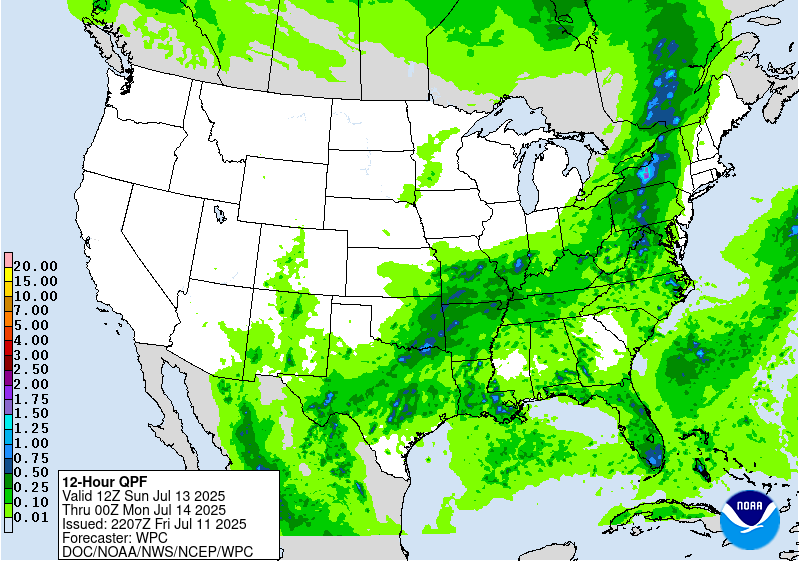
Excessive Rainfall Discussion
NWS Weather Prediction Center College Park MD
850 PM EDT Fri Jul 11 2025
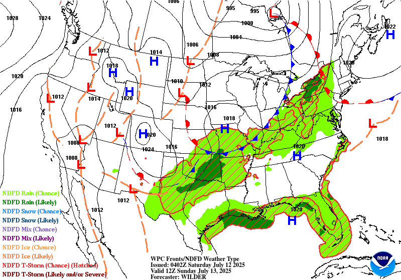
Day 3
Valid 12Z Sun Jul 13 2025 - 12Z Mon Jul 14 2025
...THERE IS A SLIGHT RISK OF EXCESSIVE RAINFALL FOR PORTIONS OF THE
SOUTHERN PLAINS AS WELL AS FOR PORTIONS OF THE MID-ATLANTIC...
...Southern Plains...
20Z Update: SLGT risk was expanded to the southwest across TX to
encompass the secondary focal area that has grown in consensus over
the past succession of forecasts. Residual heavy rainfall is likely
over parts of West TX into the Concho Valley with the risk
potentially being extended/shifted south if trends continue.
Contingency on the development of any MCV could exacerbate concerns
in any area within the SLGT, but especially across West TX and OK
where the potential is highest. Locally significant flash flooding
is plausible in proximity to any MCV development, so will have to
monitor the situation closely as we move through the weekend.
Kleebauer
..Previous Discussion..
A Slight Risk of excessive rainfall is in effect for many of the
same areas highlighted in the Day 2/Saturday ERO, for much of
West and North Texas through Eastern Oklahoma. For now, rainfall
amounts come down quite a bit on D3 as compared to D2. Thus, the
flooding potential will be significantly dependent on how the
forecast rainfall compares with Saturday, as well as how much rain
actually falls in the Slight Risk area on Saturday. Thus, for now,
a Slight Risk upgrade was introduced due to the likelihood for
additional strong thunderstorms in this area. Atmospheric moisture
amounts will increase on Sunday as compared with Saturday. The
upper level shortwave that forced the storms on Saturday will
likely get left behind and cutoff from the primary jet flow on
Sunday. This slow moving drift of the forcing should allow the
storms to also remain slow moving, and with increased moisture, the
heavy rain potential will very much still be in place on Sunday.
Thus, there is some expectation that forecast rainfall amounts in
this area will increase with time. Should this continue to be in
the same area as Saturday's storms, then it's likely additional
upgrades will be needed with future updates.
...Mid-Atlantic...
20Z Update: Main change for the forecast was the removal of the
SLGT risk across the Mohawk Valley in NYS. FFG's in this area
remain elevated as they have missed a bulk of the convective
impacts the past week. Further west, the signal looks pretty robust
for heavy rainfall over Central and Western NY state down through
Northern PA. The threat over the Mid Atlantic area remains on the
lower end of the threshold, but compromised soils from previous
convective episodes brings about some climatologically lower FFG's,
thus greater sensitivity. No changes were made to the previous
forecast in those areas as models maintain continuity in their
potential.
Kleebauer
..Previous Discussion..
The shortwave that brought heavy rains across the Midwest on Friday
and Saturday will continue into the Mid-Atlantic and Northeast on
Sunday. By Sunday the shortwave will be lifting northeastward and
becoming more negatively tilted. This will increase the associated
divergence and lift. Meanwhile, plentiful Gulf/Atlantic moisture
will stream northward ahead of the shortwave, as PWATs in some
areas exceed 2 inches. This very high level of atmospheric moisture
will support a renewed round of heavy rain from strong
thunderstorms from the DMV north across much of Pennsylvania and
upstate New York. For New York, being both at the nose of the low
level jet and in the area of greatest upper level forcing will
further increase the likelihood for training heavy thunderstorms.
Meanwhile in the DMV, while overall coverage of storms will be
lesser, given the recent storms (and likely isolated to widely
scattered coverage both Friday and Saturday), a Slight Risk was
introduced for this portion of the Mid-Atlantic. The greatest flash
flooding potential will be up towards the eastern Finger
Lakes/Central New York, and additional upgrades in this area appear
likely, especially with low FFGs already in place.
Wegman
Day 3 threat area:
www.wpc.ncep.noaa.gov/qpf/99epoints.txt
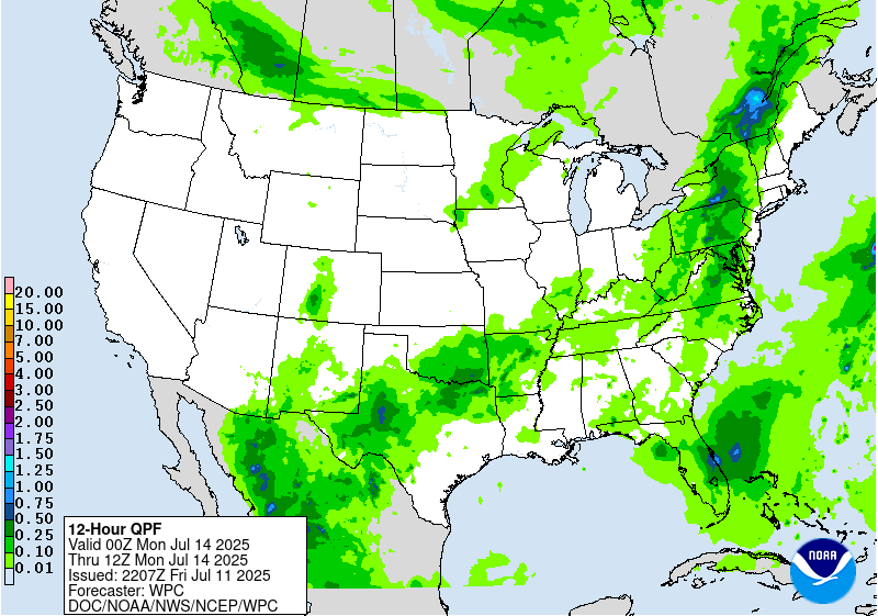
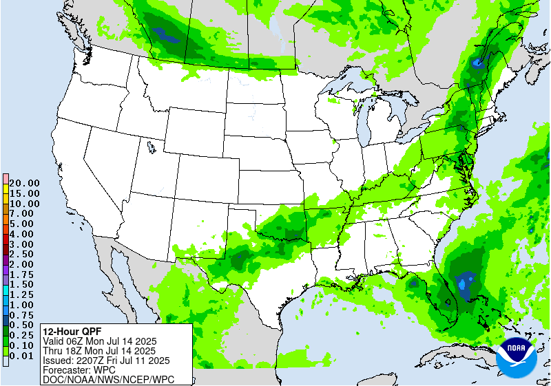
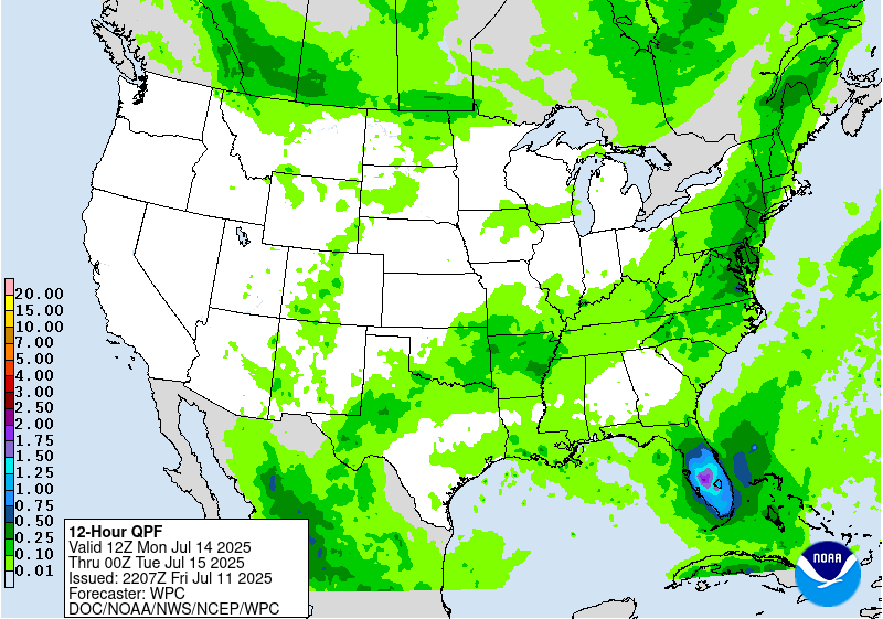
Extended Forecast Discussion
NWS Weather Prediction Center College Park MD
259 PM EDT Fri Jul 11 2025
Several areas can expect locally heavy rain with potential for
flash flooding next week. First, showers and storms are likely in
the East on Monday as moisture and instability pool along and ahead
of a cold front. A Marginal Risk remains in place across the
Northeast/Mid-Atlantic/Carolinas in the Day 4/Monday ERO. The cold
front should be more progressive in the northern half of the
Marginal, for less residence time of heavy rain, but moisture
anomalies are higher there compared to southern areas that may see
slower moving convection. As the weak front moves southward,
chances for slow moving storms in a moist and unstable environment
could continue across the Carolinas/Southeast, though with some
model spread in where exactly the convection may be maximized
(southern Appalachians, coastal areas, or in between). Broadened a
Marginal Risk on the Day 5/Tuesday ERO to include these areas, but
the areal extent may be able to lessen in future cycles if models
agree better on a focus for convection. Scattered thunderstorms
could persist in parts of the Appalachians/East into midweek and
beyond.
Just to the south, a weak surface trough/low is forecast to
retrograde from east of Georgia Monday westward across northern
Florida and into the Gulf Tuesday-Wednesday. Enhanced moisture and
this forcing could lead to heavy rain, with possible totals of
multiple inches, likely maximized on Monday across the Florida
Peninsula. There is significant uncertainty though in exactly how
much rain will fall, and with high flash flood guidance values,
maintained just broad Marginals over the state for the Monday and
Tuesday ERO periods. By Wednesday-Thursday, the low being located
in
the Gulf should allow the primary rainfall focus to be along the
central/eastern Gulf Coast.
Farther north, somewhat more strongly forced systems could lead to
heavy rain in the northern tier moving east. A cold front moving
through the northern/central Plains and eastward next week will
support showers and thunderstorms with ample moisture and
instability, resulting in a heavy to excessive rainfall threat. A
Marginal Risk is highlighted for the north-central U.S. on Monday,
expanding across much of the eastern Plains and Middle/Upper
Mississippi Valley toward the Upper Great Lakes on Tuesday, though
still with plenty of uncertainty in exactly where the heavier rain
falls. This activity should move east into the Ohio Valley and the
East Coast next Wednesday and Thursday. Farther west, areas closer
to the shortwave forcing and the back end of the front could see
heavy rain, namely the northern Rockies and northern High Plains
Monday-Tuesday, and Marginal Risks are also in place there.
Weak upper energy across Texas embedded within the mean
subtropical upper ridge and above average moisture could continue a
heavy rain threat from the southern Plains just reaching the
Lower/Middle Mississippi Valley on Monday, where there is a
Marginal Risk in the Day 4 ERO. By Day 5/Tuesday, will highlight a
Marginal in Far West Texas into the Sacramento Mountains (with burn
scars particularly sensitive in the latter) as moisture lingers
over terrain. As the week progresses, monsoonal moisture increases
across the Southwest/Four Corners/southern Rockies region.
Hot weather will remain for much of the western U.S. through
Monday as upper ridging persists. Daily highs will be above normal
with many locations climbing into the 100s and 110s for the Desert
Southwest, and nearing/exceeding 100F farther north in
interior/lower elevation areas of the Great Basin. Temperatures
will moderate below normal by Tuesday for the northern Plains with
high temperatures 15 to 25 degrees below normal for Tuesday and
Wednesday. Temperatures look to be a few degrees cooler than
average for the south-central U.S. for much of next week as clouds
and rain hold temperatures down. The Great Lakes and Northeast
will see a return to above normal temperatures on Tuesday after the
trough clears, with some Major (level 3/4) HeatRisk showing up in
those areas by midweek. Meanwhile the Southeast should be near
normal to a few degrees above, for typical summer heat and
humidity.
Tate/Santorelli


