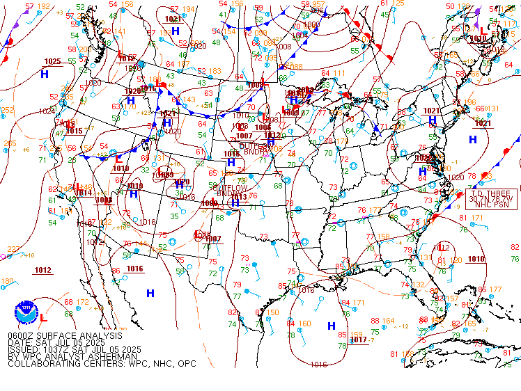
Excessive Rainfall Discussion
NWS Weather Prediction Center College Park MD
852 PM EDT Sat Jul 5 2025
Day 1
Valid 01Z Sun Jul 06 2025 - 12Z Sun Jul 06 2025
...THERE IS A MODERATE RISK OF EXCESSIVE RAINFALL FOR A PORTION OF
CENTRAL TEXAS...
...Central Texas...
A new Moderate Risk area is out for a portion of central Texas.
The remains of Barry aloft and resultant "new" 850 hPa cyclone are
parting ways in a sheared environment, with the 850 hPa low moving
west while the mid-level trough moves east. Normally the night
after this happens is the last night/subsequent morning of heavy
rain potential. Effective bulk shear due to the opposing low-level
and upper-level flow is sufficient for organized convection and
cells being stuck in place. There's an instability gradient near
29.5N latitude, seen on SPC mesoanalyses, that's creeping north and
likely to be the better focus for heavy rainfall this period as
low-level inflow intercepts it -- used this as the southern bound
of the risk areas. The retrograding upper low is also a possible
spot for such...used its track as the northern bound of the risk
area. Some retrograding convection is possible on its west side as
outflow boundaries try to instigate new convection on that side of
the 850 hPa circulation/trough. Precipitable water values remain
near and above 2.25". ML CAPE south of the instability gradient is
2000+ J/kg. Convective environments with this much moisture in
northeast shear since 2016 (August 2016 convective low in Louisiana
and Imelda in 2019) have favored the wetter mesoscale guidance, so
leaned a bit on the high- resolution NAM, HRRR, and RRFS. Hourly
rain amounts to 4", with local amounts to 8", appear the best bet.
This on its own is problematic, but the heavy rains could also fall
on already saturated ground. Coordination with the TX forecast
offices -- SJT/San Angelo, EWX/New Braunfels, and FWD/Fort Worth --
as well as the National Water Center led to the new Moderate Risk
area. As a side note, the remains of Barry are the 20th tropical
cyclone or remnant since 1913 to produce 15"+ across interior
portions of Texas.
...Carolinas/T.S. Chantal...
Much of the high resolution guidance for Chantal keeps the focus of
heavy rainfall into the early morning hours Sunday near the NC/SC
border. The guidance has had a westward bias thus far, and radar
trends show that what passes as a CDO/Central Dense Overcast keeps
moving north more towards NC. Both the HREF/RRFS insist on a
northwest turn with an occluded look overnight, which would be
something and not befit a tropical cyclone that's supposed to be in
a less sheared environment. Tightened up the western gradient of
the risk areas as a precaution -- the SC portion of the risk areas
remains the most uncertain.
...Midwest...
Trimmed the area per radar reflectivity trends and HREF output.
Activity should forward propagate and fade overnight.
...Northern High Plains...
A well-defined shortwave moving into the northern High Plains is
leading to widely scattered thunderstorms. Forecast PWs are
expected of 1 to 1.25 inches (1 to 1.5 std dev above normal) are
high enough to imply saturation in the High Plains, implying
rainfall efficiency. While a widespread heavy rainfall event is
not expected, heavy rainfall rates and some potential for
redeveloping storms may produce locally heavy amounts (greater than
an inch) and isolated runoff concerns.
...Southeast Arizona...
See Mesoscale Precipitation Discussion #598 for more details.
...Western Florida...
Pared back the Marginal Risk area to western FL per radar
reflectivity trends and 18z HREF output. Convection should fade
and/or move westward into the Gulf.
Roth
Day 1 threat area:
www.wpc.ncep.noaa.gov/qpf/94epoints.txt
Excessive Rainfall Discussion
NWS Weather Prediction Center College Park MD
416 AM EDT Sun Jul 6 2025
Day 1
Valid 12Z Sun Jul 06 2025 - 12Z Mon Jul 07 2025
...THERE IS A SLIGHT RISK OF EXCESSIVE RAINFALL FOR PORTIONS OF
CENTRAL TEXAS AS WELL AS FOR PORTIONS OF THE CAROLINAS...
...Carolinas/Southern Virginia...
Tropical Storm Chantal is forecast to move inland across
northeastern South Carolina early in the period and weaken as it
moves into central North Carolina later today into the overnight.
The growing consensus of the model QPF has an "occluded look" to
it, with the heaviest amounts setting up west of the track. Not
much change was made to the previous Slight Risk area, with minor
adjustments based on the new HREF guidance. This area reflects the
HREF higher neighborhood probabilities for 3+ inches, which extend
from parts of the Pee Dee region and north-central SC through
central NC into far south-central VA.
...Central Texas...
Fueled by a lingering axis of deep moisture (2 to 2.25 PWs
according to recent runs of the RAP) and weak mid level energy
drawn south by an upstream ridge, concerns remain for additional
heavy rains and flooding across portions of North Texas back into
South-Central Texas and the Hill Country. QPF has trended upward
within the highlighted region, with the HREF once again showing a
strong signal for locally heavy amounts over 3 inches within the
Slight Risk area. These amounts would easily exceed FFGs over those
areas recently impacted by heavy amounts. Therefore, will continue
to monitor for the potential need to upgrade to a Moderate Risk
for parts of the region.
...Upper Great Lakes to the Central Plains/Ozarks...
A series of shortwaves will move through a broad upper trough
centered over the northern Plains, pushing a wavy cold front, that
extends from the upper Great Lakes back into the central Plains,
farther south. A deep moisture pool ahead of the front (PWs over 2
inches in some locations) will fuel widespread shower and storm
coverage. Overnight guidance indicates that in addition to the
ample moisture, favorable upper jet dynamics and some potential for
storm training, will contribute to a greater threat for heavier
amounts (2-3 inches) across parts of Lower Michigan. However,
locally heavy amounts, along with isolated flooding concerns,
cannot be ruled out further southeast along and ahead of the front.
...Central and Southern High Plains into the Southern Rockies...
Moist upslope flow will contribute to afternoon storm initiation
along the high terrain, with the guidance continuing to present a
notable signal for organized development contributing to heavy
amounts across portions of western Kansas and Nebraska. The
overnight HREF indicates 2-3 inches are likely for parts of the
region. Storms are expected to remain less organized further to
south, but may fire and produce isolated flooding concerns across
the more vulnerable parts of central and eastern New Mexico.
...Southern Louisiana/Mississippi...
Models show an upper low over the northeastern Gulf retrograding
westward back along the Gulf Coast. This will bring increasing rain
chances to the region, with the potential for heavy amounts. A
Marginal Risk was maintained for parts of southern Louisiana and
southwestern Mississippi, where the HREF presents a strong signal
for amounts over 2 inches.
Pereira
Day 1 threat area:
www.wpc.ncep.noaa.gov/qpf/94epoints.txt
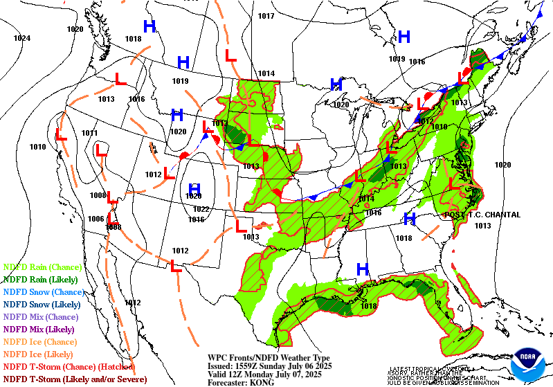
Excessive Rainfall Discussion
NWS Weather Prediction Center College Park MD
416 AM EDT Sun Jul 6 2025
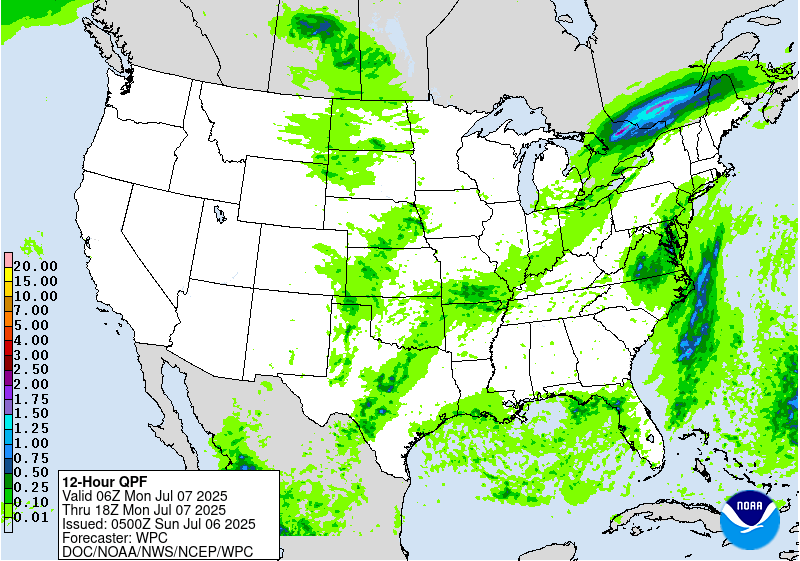
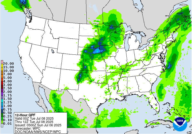
Day 2
Valid 12Z Mon Jul 07 2025 - 12Z Tue Jul 08 2025
...THERE IS A MARGINAL RISK OF EXCESSIVE RAINFALL FROM THE UPPER
MIDWEST TO THE SOUTHWEST, THE NORTHEAST TO THE SOUTHERN PLAINS,
PORTIONS OF CENTRAL TEXAS, AND EASTERN NORTH CAROLINA TO EASTERN
PENNSYLVANIA AND NEW JERSEY...
...Eastern North Carolina to Eastern Pennsylvania and New Jersey...
Although the surface circulation may no longer be well-defined,
the mid level remnants and an its associated plume of deeper
moisture are expected to lift north from eastern North Carolina
along the Mid-Atlantic Coast ahead of an upstream trough, bringing
the potential for locally heavy rain and perhaps some isolated
flooding concerns from eastern North Carolina to eastern
Pennsylvania and New Jersey.
...Northeast to Mid Mississippi Valley/Ozarks...
A frontal boundary will continue to slide farther east across the
Northeast this period. Deep moisture ahead of the boundary (PWs
1.75-2 inches and 2-3 std dev above normal), along with favorable
upper jet forcing are expected to contribute to some organized
heavier amounts from western and northern New York into parts of
northern New England. Less organized activity is expected farther
southeast. However, once again locally heavy amounts and isolated
flooding concerns cannot be ruled out for areas back through the
Ohio Valley into the mid Mississippi Valley and Ozark region.
...Southern Plains...
The latest HREF shows that activity developing over parts of Texas
on Day 1 may continue into Day 2, producing additional heavy
amounts and prolonging flooding concerns across parts of Texas
including portions of South-Central Texas and the Hill Country
northeastward through North Texas...
...Upper Midwest to the Southwest...
Amplifying southerly low level winds over the Plains will support
increasing moisture across the central into the northern Plains.
This moisture along with mid level energy moving out into the
region, will support widespread showers and thunderstorms, with
the guidance showing a signal for organized activity developing
over the central High Plains. Forecast confidence is limited by
significant model spread in the details. However, the potential for
at least isolated flash flooding concerns cannot be ruled out.
Farther to the south, activity again is expected to be less
organized. But again, cannot rule out at least an isolated flash
flooding concern, especially across vulnerable portions of eastern
and central New Mexico.
Pereira
Day 2 threat area:
www.wpc.ncep.noaa.gov/qpf/98epoints.txt
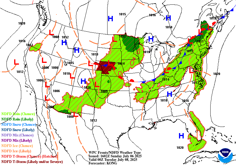
Excessive Rainfall Discussion
NWS Weather Prediction Center College Park MD
416 AM EDT Sun Jul 6 2025
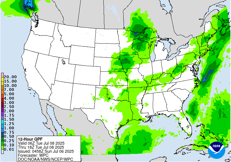
Day 3
Valid 12Z Tue Jul 08 2025 - 12Z Wed Jul 09 2025
...THERE IS A MARGINAL RISK OF EXCESSIVE RAINFALL FROM THE MIDWEST
AND THE NORTHEAST TO THE SOUTHERN HIGH PLAINS...
...Northeast through the Ohio Valley...
A cold front will continue to slide slowly southeast across the
Northeast and the Mid Atlantic. Deepening moisture ahead of the
boundary (increasing above 2 inches in many locations) will raise
the potential for at least locally heavy amounts and isolated
flooding to occur.
...Midwest to the Southern High Plains/Rockies...
An upper level shortwave and associated axis of deeper moisture may
produce storms with locally heavy amounts from the mid Mississippi
Valley/Great Lakes region back through the mid Mississippi and
lower Missouri valleys into the southern Plains.
Meanwhile, low level upslope flow may produce another round of
showers and storms developing along the southern Rockies into the
High Plains.
Pereira
Day 3 threat area:
www.wpc.ncep.noaa.gov/qpf/99epoints.txt
Extended Forecast Discussion
NWS Weather Prediction Center College Park MD
234 AM EDT Sun Jul 6 2025
Showers and thunderstorms are expected to be focused in proximity
to progressive cold fronts, stalled boundaries and round the upper
high in the Southern Rockies. The wavy front into the eastern U.S.
may be a focus for heavier rain and thunderstorms. This includes
areas from the Corn Belt into the Midwest and Ohio Valley,
Appalachians, Mid-Atlantic, and Northeast. There are Marginal Risks
in place (level 1 of 4) for the Central Plains/Midwest for Day 4,
for the parts of the Dakota/Upper Mississippi Valley on Day 5 and
for portions of the Mid-Atlantic/coastal Carolinas for Day 4/5 for
an axis of heavier rainfall possible south of a frontal boundary.
Many locations will have daily maximums climbing well into the
100s at lower elevations across the Southwest, which will greatly
limit rain except for perhaps far southeastern Arizona into New
Mexico early in the week. Experimental HeatRisk values may rise to
Major or Extreme levels (3 out of 4 or 4 out of 4) from the
California deserts into southern Nevada, Utah, and Arizona. Extreme
Heat Watches have been raised for parts of Arizona through at least
Thursday.
Campbell


