Excessive Rainfall Discussion
NWS Weather Prediction Center College Park MD
830 PM EDT Thu Jun 11 2026
Day 1
Valid 01Z Fri Jun 12 2026 - 12Z Fri Jun 12 2026
...THERE IS A SLIGHT RISK OF EXCESSIVE RAINFALL FOR PORTIONS OF THE
MIDWEST...
01Z Update...
Main changes were limited to removing areas where convective has
exited in the Upper Midwest/Great Lakes and in parts of New York of
Pennsylvania. Heavy rainfall was still being produced by
convection making its way across the southern Great Lakes into
parts of the Mid-Mississippi Valley where deep moisture remained in
place ahead of an advancing cold front and a jet streak aloft was
providing good upper level support.
In the eastern US from parts of southern New York into the Mid-
Atlantic region...locally heavy rainfall could still result in
isolated instances for flooding. However...the threat is being
mitigated by progressive forward speed of the storms and by the
loss of daytime heating.
Bann
16Z update...
Several locations picked up 1 to 4 inches of rain overnight for
the Midwest/Upper Midwest with the organized convection; prolonging
the multi-day wet pattern for much of Iowa and ongoing areal
flooding. Training and backbuilding of thunderstorms are expected
to persist during the afternoon and into the evening hours for
parts of Iowa and Illinois which will keep an elevated threat for
scattered flash flooding while another round of convection lifts
northeast into Wisconsin and Michigan with hourly rainfall rates.
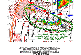
The Slight Risk area was expanded northward along the northern
boundary in Wisconsin and lower Michigan. Refer to WPC MPD 384 for
additional details.
Campbell
Early this morning, a frontal wave developed over the central
Plains ahead of a strong upper level trough that will lift into the
Midwest today. This wave of low pressure is forecast to surge
northeast into the Midwest and be accompanied by an area of
enhanced convection in the vicinity of the low. A strengthening low
level jet on the leading edge of this disturbance will bring a
surge of moisture (PWAT values > 2 inches) and instability (MUCAPE
> 3000 J/kg) into the Midwest and create a sheared environment that
will allow for organized convection with highly efficient rainfall
rates up to 2-4 inches per hour. A Slight Risk of excessive
rainfall is in effect for portions of the Midwest where the hi-res
CAMs are showing the highest rainfall totals. There was some
consideration of upgrading to a Moderate Risk for portions of Iowa,
Wisconsin, and Illinois given recent heavy rains and soil
saturation, but the highest rainfall totals today are forecast to
be displaced to the north of where the heaviest rain fell on
Wednesday, which should keep the risk of flash flooding more in
line with a high-end Slight. On the backside of the frontal wave,
the cold front will surge southeast across the central and southern
Plains this afternoon with showers and storms expected to form
along the front. Given the highly moist and unstable environment on
the warm side of the boundary, these storms will be capable of
producing high rainfall rates, but the progressive nature of the
front should help limit the risk of flash flooding. A Marginal Risk
area extends back into the southern Plains where locally heavy
rainfall may lead to isolated instances of flash flooding.
.Ohio Valley to Mid-Atlantic...
An upper level shortwave trough is expected to move southeast
across the Ohio Valley and Mid-Atlantic today, which will provide
upper level support for the development of scattered showers and
storms this afternoon. Warm, moist air will be in place across
these regions, with PWAT values generally ranging from 1.75-2
inches, which will support rainfall rates of 1-2 inches. Elevated
instability (>2000 J/kg) should allow for some deeper convective
cells that will be capable of producing locally heavy rainfall.
Isolated instances of flash flooding will be possible, especially
if heavy rain occurs in urban environments, so there is a Marginal
Risk of excessive rainfall extending from the Ohio Valley to the
Mid-Atlantic. Northwesterly upslope flow will also result in
enhanced precipitation totals along the central Appalachians that
could create isolated flooding concerns in this region as well,
which is included in the Marginal Risk area.
.Southwest Florida...
Southeasterly flow has increased PWAT values above 2 inches across
Central and South Florida, which will allow for very heavy
rainfall rates of 2-4 inches per hour in convection along the sea
breeze boundaries this afternoon. Hi-res CAMs show the Atlantic and
Gulf sea breezes colliding over Southwest Florida, which could
result in flash flooding concerns for urban areas. Therefore, there
is a Marginal Risk of excessive rainfall for urban areas along the
west coast of the Florida Peninsula from Tampa south.
Dolan
Day 1 threat area:
www.wpc.ncep.noaa.gov/qpf/94epoints.txt
Excessive Rainfall Discussion
NWS Weather Prediction Center College Park MD
408 AM EDT Fri Jun 12 2026
Day 1
Valid 12Z Fri Jun 12 2026 - 12Z Sat Jun 13 2026
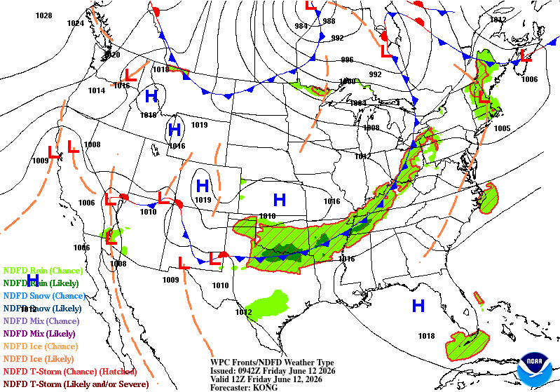
...THERE IS A MARGINAL RISK OF EXCESSIVE RAINFALL FROM THE SOUTHERN
ROCKIES THROUGH THE MID-SOUTH, MID-ATLANTIC, AND NORTHEAST AS WELL
AS FOR CENTRAL AND SOUTHWEST FLORIDA...
...South-Central States through Northeast...
An upper trough over Michigan early this morning will shift east
across the Northeast through tonight. Prefrontal activity ahead of
the associated cold front persists over Lake Erie and the lower
Ohio Valley with stronger activity over the Oklahoma/Arkansas
border early this morning. Deep moist convection develops diurnally
today ahead of the cold front east of the Mid-South and a warm
front lifting over the southern Plains. An extensive Marginal Risk
remains from the southern Rockies/Sacramento and Davis Mtns across
Texas/Oklahoma, the Mid-South/Tennessee Valley and over New
England. Some activity is still progged over the Central
Appalachians, so the Marginal Risk was maintained there, though it
is a notably low risk compared to northern New England and the
Tennessee Valley where PW anomalies are over 2 sigma (more like a
peak of 1.5 sigma in the Mid-Atlantic). Most of this activity will
be fairly progressive hence no Slight Risks at this time.
Some trimming of the north side to the Marginal Risk was made,
though timing tonight with surging Gulf moisture limits that
reduction, particularly based on the 06Z HRRR with central
Missouri activity late tonight.
...Central and Southwest Florida...
Anomalous moisture will reside over southwest and central portions
of the Florida Peninsula today, though it should be a little less
in terms of PW compared to Thursday. Convection along the sea
breezes should produce very heavy rainfall that could lead to
flooding concerns for urban areas in Central and Southwest Florida.
A Marginal Risk remains in effect with Tampa Bay removed due to CAM
consensus to the east/south of there.
Jackson
Day 1 threat area:
www.wpc.ncep.noaa.gov/qpf/94epoints.txt
Excessive Rainfall Discussion
NWS Weather Prediction Center College Park MD
408 AM EDT Fri Jun 12 2026
Day 2
Valid 12Z Sat Jun 13 2026 - 12Z Sun Jun 14 2026
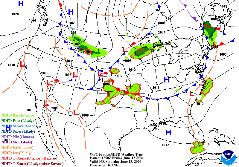
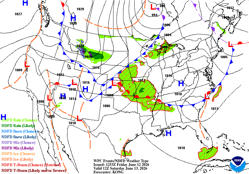
...THERE IS A SLIGHT RISK OF EXCESSIVE RAINFALL FOR PORTIONS OF THE
CENTRAL PLAINS THROUGH THE MIDDLE MISSISSIPPI VALLEY INTO THE
LOWER OHIO VALLEY...
An upper trough swings down the northern Plains Saturday, pushing a
cold front across the central Plains and Midwest through Saturday
night. Meanwhile, a warm front tracks from Oklahoma through
Illinois ahead of the cold front, creating focus for strong
convergence in a very warm, moist, and unstable air mass. Resultant
heavy thunderstorms look to organize and repeat from the central
Kansas/Oklahoma border through central/southern Illinois and
western Kentucky where the Slight Risk was expanded a bit.
Particular focus for heavy rain remains near the Kansas/Missouri
border where a higher than normal Slight Risk is noted. Scattered
instances of flash flooding can be expected and a targeted Moderate
Risk is possible.
More isolated heavy thunderstorms are also expected over the
eastern New Mexico and west Texas terrain and nearby plains where
the Marginal Risk remains.
The Marginal Risk was removed from most of Michigan based on the
00Z high-res solutions available with little PW anomaly noted.
Jackson
Day 2 threat area:
www.wpc.ncep.noaa.gov/qpf/98epoints.txt
Excessive Rainfall Discussion
NWS Weather Prediction Center College Park MD
408 AM EDT Fri Jun 12 2026
Day 3
Valid 12Z Sun Jun 14 2026 - 12Z Mon Jun 15 2026
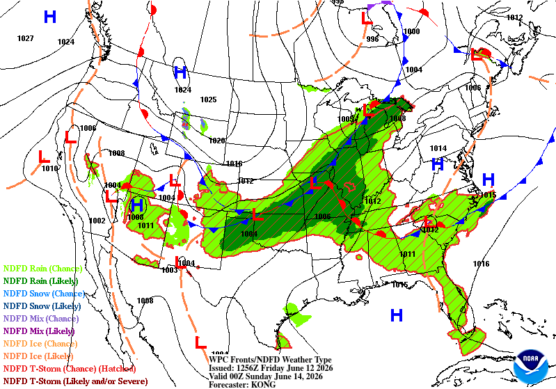
...THERE IS A SLIGHT RISK OF EXCESSIVE RAINFALL FOR PORTIONS OF
TEXAS AND THE LOWER MISSISSIPPI VALLEY...
...Southern Rockies, Texas to Southeast...
A cold front pushes down the Southern Plains into Texas on Sunday.
This shunts the heavy rain focus south of Saturday and provides a
strong focus for convective development in a rich Gulf-sourced
moisture environment. PW anomalies are 2 to 3 sigma above normal
across Texas (south of the Panhandle) by that afternoon with 2
sigma anomalies expanding east to Alabama by late Sunday night.
Expansion of the Slight Risk to both North Texas and the Houston
metro areas are warranted given the environment as well as the 00Z
consensus of the UKMET and EC-AIFS for the Houston area, and the
RRFS and RDPS for North Texas. Furthermore, a decent signal for
lasting thunderstorm development is over West Texas in the Permian
Basin into the Concho Valley, so a Slight Risk was raised there as
well.
Additional terrain driven diurnal activity is expected over the
Southern Rockies/Sacramento and Davis Mtns. This activity should
spread southeast through the evening, so the Marginal Risk was
expanded over the southern High Plains.
A surge of moisture up the southern Appalachians Sunday morning
brings enough of a heavy rain threat for a Marginal Risk expansion
up to the westernmost section of Virgina.
...Hampton Roads and Delmarva...
Southwesterly low level flow from the Carolinas bring 2" PW to the
Mid- Atlantic coast Sunday afternoon ahead of a cold frontal
passage that night. Evening thunderstorms should be heavy and slow
enough to warrant a Marginal Risk.
Jackson
Day 3 threat area:
www.wpc.ncep.noaa.gov/qpf/99epoints.txt
Excessive Rainfall Discussion
NWS Weather Prediction Center College Park MD
408 AM EDT Fri Jun 12 2026
Day 4 and Day 5
Valid 12Z Mon Jun 15 2026 - 12Z Wed Jun 17 2026
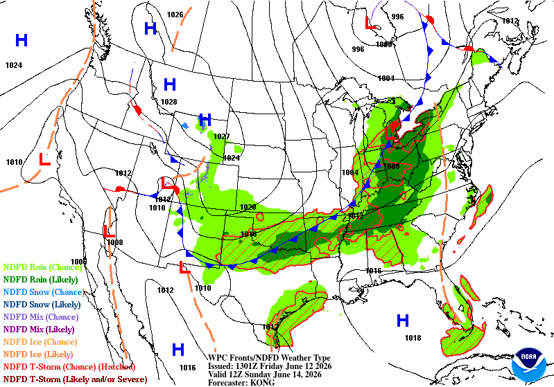
...A SLIGHT RISK OF EXCESSIVE RAINFALL EXISTS FOR PORTIONS OF THE
SOUTHERN PLAINS, LOWER MISSISSIPPI VALLEY, AND THE SOUTHEAST...
Overall, not much change from the previous forecast, with the
overnight guidance continuing to present a good signal for highly-
efficient training storms along a slow-moving front settling into
the region.
Models continue to show a cold front settling slowly south though
the southern Plains, lower Mississippi Valley, and the Southeast as
shortwave energy gradually amplifies a broad upper trough centered
along the Mississippi Valley on Monday. A deepening pool of
moisture along the front, fed by southerly low level inflow from
the western Gulf, will fuel the potential for highly-efficient
showers and storms. Guidance continues to show PWs increasing to
2.25 inches (2.5 to 3 std dev above normal) along and ahead the
front from south South Texas to southern Alabama on Monday.
Interacting with this moisture is expected to be an area of
enhanced ascent provided by right-entrance region upper jet forcing
positioned along the base of the amplifying trough. In addition to
the deep moisture and large-scale ascent, repeating storms are
expected to raise the potential for heavy amounts and flash
flooding concerns. A Slight Risk was maintained from southeastern
Texas to central and southern Alabama on Day 4.
By Tuesday, the upper trough axis begins to shift to the east,
pushing the front, deeper moisture, and the better chance for heavy
rain farther south and east along the Gulf Coast. For Day 5, a
Slight Risk was drawn from southeatern Lousiana to southwestern
Georgia.
While Slight Risks were drawn for both periods, given the potential
for several inches of rain in some locations, an upgrade to a
Moderate Risk may be required in future updates if the signal
persists as the event draws nearer.
Pereira
Excessive Rainfall Discussion
NWS Weather Prediction Center College Park MD
408 AM EDT Fri Jun 12 2026
Day 4 and Day 5
Valid 12Z Mon Jun 15 2026 - 12Z Wed Jun 17 2026
...A SLIGHT RISK OF EXCESSIVE RAINFALL EXISTS FOR PORTIONS OF THE
SOUTHERN PLAINS, LOWER MISSISSIPPI VALLEY, AND THE SOUTHEAST...
Overall, not much change from the previous forecast, with the
overnight guidance continuing to present a good signal for highly-
efficient training storms along a slow-moving front settling into
the region.
Models continue to show a cold front settling slowly south though
the southern Plains, lower Mississippi Valley, and the Southeast as
shortwave energy gradually amplifies a broad upper trough centered
along the Mississippi Valley on Monday. A deepening pool of
moisture along the front, fed by southerly low level inflow from
the western Gulf, will fuel the potential for highly-efficient
showers and storms. Guidance continues to show PWs increasing to
2.25 inches (2.5 to 3 std dev above normal) along and ahead the
front from south South Texas to southern Alabama on Monday.
Interacting with this moisture is expected to be an area of
enhanced ascent provided by right-entrance region upper jet forcing
positioned along the base of the amplifying trough. In addition to
the deep moisture and large-scale ascent, repeating storms are
expected to raise the potential for heavy amounts and flash
flooding concerns. A Slight Risk was maintained from southeastern
Texas to central and southern Alabama on Day 4.
By Tuesday, the upper trough axis begins to shift to the east,
pushing the front, deeper moisture, and the better chance for heavy
rain farther south and east along the Gulf Coast. For Day 5, a
Slight Risk was drawn from southeatern Lousiana to southwestern
Georgia.
While Slight Risks were drawn for both periods, given the potential
for several inches of rain in some locations, an upgrade to a
Moderate Risk may be required in future updates if the signal
persists as the event draws nearer.
Pereira


