Excessive Rainfall Discussion
NWS Weather Prediction Center College Park MD
731 PM EDT Mon Jul 7 2025
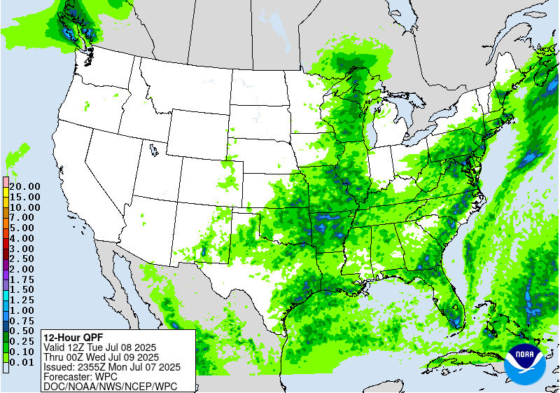
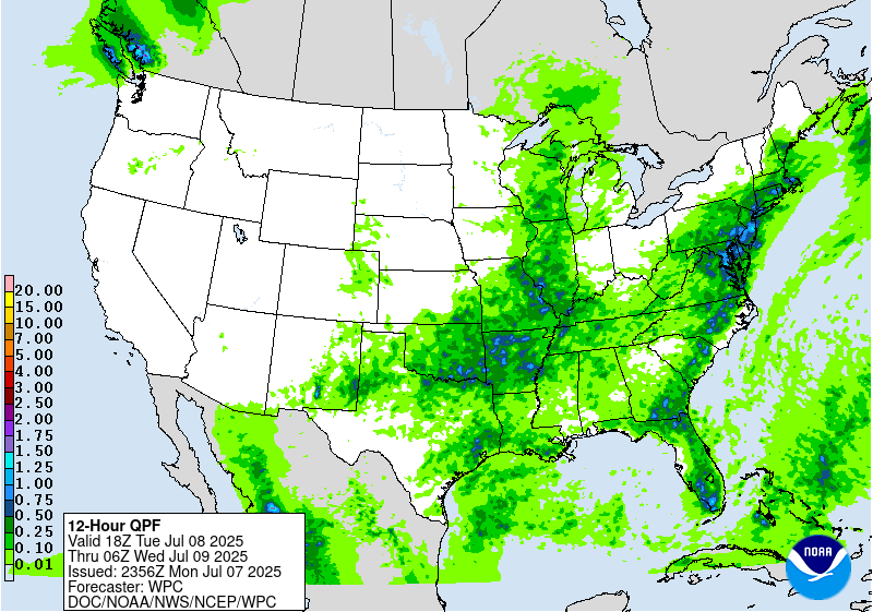
Day 1
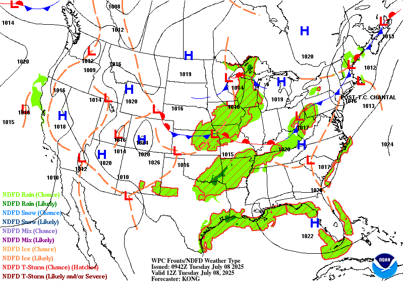
Valid 01Z Tue Jul 08 2025 - 12Z Tue Jul 08 2025
...THERE IS A SLIGHT RISK OF EXCESSIVE RAINFALL IN AND NEAR
PORTIONS OF OHIO, WEST VIRGINIA, & SOUTHWEST PENNSYLVANIA...
OH/WV/PA/MD...
Convection is trying to align across portions of the Upper Ohio
Valley at the present time. Shifted the Slight Risk previously in
this area somewhat to account for current conditions. See
Mesoscale Precipitation Discussion #615 for more details on the
threat there.
Elsewhere & Otherwise...
Activity across the Ohio Valley, Lower Mississippi Valley, and
Northeast is expected to fade overnight into the early morning
hours. Effective bulk shear supports organization across the
northern half of the Mississippi Valley, northern and central
Plains, and Northeast, but systems in these regions will be mobile,
limiting excessive rainfall/flash flood potential. Post-Tropical
Cyclone Chantal may cause a brief skirmish of heavy rainfall near
Nantucket, Martha's Vineyard, and Cape Cod during the early morning
hours on Tuesday, but the system will be moving quickly. The most
persistent convection should be with a front moving across MN & WI.
Where convection manages hold on and train/merge in any of these
areas, hourly rain amounts to 2" with local amounts to 4" will be
possible, as sufficient moisture and instability exists to allow
for this possibility.
Roth
Day 1 threat area:
www.wpc.ncep.noaa.gov/qpf/94epoints.txt
Excessive Rainfall Discussion
NWS Weather Prediction Center College Park MD
731 PM EDT Mon Jul 7 2025
Day 2
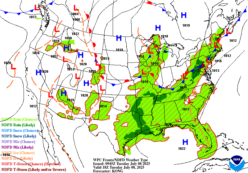
Valid 12Z Tue Jul 08 2025 - 12Z Wed Jul 09 2025
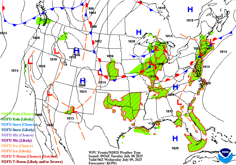
...THERE IS A SLIGHT RISK OF EXCESSIVE RAINFALL FOR THE EASTERN
MID-ATLANTIC STATES AND SOUTHERN NEW ENGLAND, AS WELL AS PARTS OF
THE SOUTHERN PLAINS...
...Mid-Atlantic and Northeast...
Post-tropical cyclone Chantal will be exiting east of Cape Cod to
start the period as it continues to get caught up in increasing
southwesterlies downstream of a trough approaching from the Great
Lakes. This trough will continue to translate eastward through the
day, but will be slow to advect due to downstream Bermuda-type
ridging. Between these two features, SW flow will remain prevalent
over the area, with 850-500mb winds being nearly unidirectional
from the W/SW at 15-20 kts. This will result in a continued
extremely moist environment with PWs likely eclipsing 2" from
eastern VA through southern New England Tuesday afternoon,
coincident with a plume of SBCAPE exceeding 2000 J/kg.
Into these impressive thermodynamics, a shortwave embedded within
the mean flow will traverse northeast ahead of a cold front and
along a surface trough, providing additional ascent atop the
already impressive convergence on these boundaries. This suggests
showers and thunderstorms will become widespread, which is
additionally supported by high-res CAM simulated reflectivity.
Storms that develop will move very slowly, and Corfidi vectors
collapsed to just around 5 kts will support backbuilding and
training echoes along the surface trough and front. With warm cloud
depths potentially eclipsing 14,000 ft, this will support efficient
warm-rain processes and rain rates above 2"/hr at times. Where
training occurs, this could result in total rainfall in excess of
3", with instances of flash flooding possible across much of the
I-95 corridor from Richmond, VA to Portland, ME, and a slight risk
has been added for this area.
...Southern Plains through the Ohio Valley...
A wavering front will press eastward from Oklahoma through Ohio
during Tuesday, providing forcing for ascent through low-level
convergence. This frontal convergence will work in tandem with
subtle height falls as the driving trough pushes south and east,
and modest PVA as spokes of vorticity rotate eastward through the
flow. While in general this will result in scattered thunderstorms
developing along the front with rainfall rates of 1+"/hr, there may
be a localized maxima of heavy rain potential from eastern OK into
northern AR.
In this portion of the Southern Plains and into the Ozarks, an
impressive shortwave is progged to push southward Tuesday evening/night
and suppress the ridge to the west. This will drive locally
enhanced ascent. At the same time, lingering boundaries from Monday
night's convection and scattered storms earlier on Tuesday will
provide additional focus, and the CAMs, while differing spatially
and temporally, suggest locally more organized convection Tuesday
night. As this shortwave drops south and interacts with surface
boundaries, it will impinge into increasingly robust thermodynamics
as the 20 kt LLJ pushes PWs to around 2 inches coincident with
MUCAPE surging to 2000 J/kg. The HREF hourly rain rate
probabilities for 2"/hr peak around 20% during this time,
suggesting intense rainfall that could overwhelm soils and produce
runoff, especially where backbuilding/training occurs due to
Corfidi vectors aligning against the mean wind. Additionally some
enhanced shear during this time could organize convection into an
MCS, leading to even more impressive rain rates. Although
confidence is modest in the exact timing and placement, both the
HREF and REFS have increased probabilities for 3" (60%) and 5"
(30%) of rainfall, leading to the upgraded SLGT risk area.
...Upper Midwest...
A wave of low pressure and accompanying surface trough will move
progressively eastward from Minnesota into Michigan the first half
of Tuesday. While this will be generally fast moving, it will
impinge into a favorable environment to support heavy rain rates
which will likely eclipse 1"/hr, especially where it overlaps a
ribbon of MUCAPE reaching 1000-2000 J/kg. The fast motion will
limit total rainfall, but in some places that receive multiple
rounds of heavy rain, event totals could reach 2-3". This falling
atop sensitive soils (FFG as low as 1-1.5"/3hrs) could produce
instances of flash flooding.
......Southern New Mexico...
Another daily round of showers and thunderstorms is expected to
develop in the high terrain and then drop southeast into the High
Plains and southern portions of New Mexico. Although storms are
expected to be generally progressive as they come off the terrain
(0-6km mean winds from the north around 15 kts), they will move
into an axis of more favorable thermodynamics characterized by PWs
of above 1" and MUCAPE approaching 1000 J/kg. This could support
briefly heavy rain rates above 1"/hr, supporting an isolated risk
for flash flood impacts across urban areas or sensitive terrain and
burn scars.
Weiss
Day 2 threat area:
www.wpc.ncep.noaa.gov/qpf/98epoints.txt
Excessive Rainfall Discussion
NWS Weather Prediction Center College Park MD
731 PM EDT Mon Jul 7 2025
Day 3
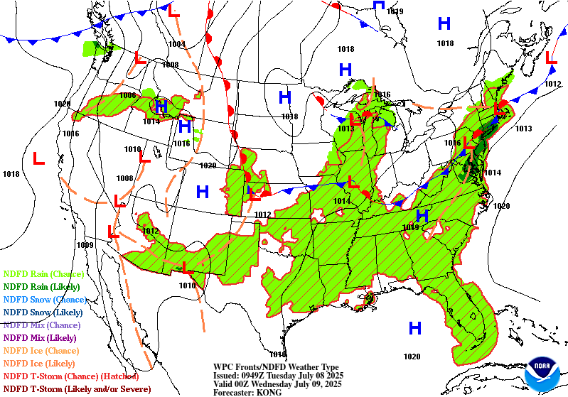
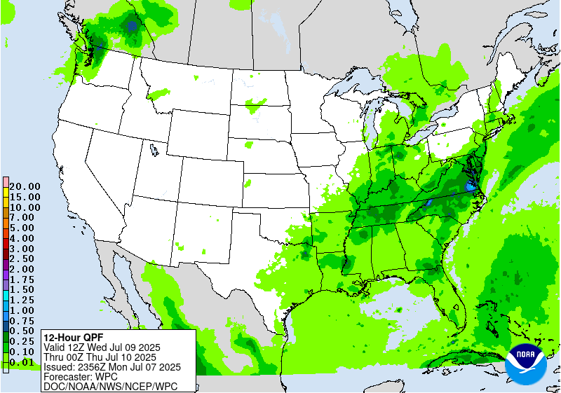
Valid 12Z Wed Jul 09 2025 - 12Z Thu Jul 10 2025
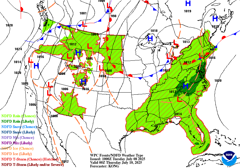
...THERE IS A SLIGHT RISK OF EXCESSIVE RAINFALL FOR THE EASTERN
MID-ATLANTIC STATES...
...Mid-Atlantic...
Quasi-stationary front from Tuesday will linger in a general east-
to-west fashion on Wednesday across the Mid-Atlantic States. Along
this boundary, a shortwave will press east within the approaching
longwave trough, leading to weak low pressure development moving
east along this front. The accompanying ascent will act favorably
into continued robust thermodynamics with PWs around 2 inches
(above the 90th percentile according to NAEFS ensemble tables) and
1000+ J/kg SBCAPE during the afternoon. Increasing 0-6km bulk shear
and aligned 0-6km mean winds to the front suggests storms will
repeatedly develop to the SW and then train ENE across the Mid-
Atlantic states. Not only will this result in heavy rainfall which
may exceed 3 inches in some areas, but it will occur across primed
soils from heavy rainfall on D1 and D2, enhancing the flash flood
risk, and a SLGT risk has been added from central NJ through
northern NC where both GEFS and ECENS 24-hr rainfall probabilities
peak.
...Ozarks through the Southern Ohio Valley...
Stalled frontal boundary will gradually begin to lift northeast on
Wednesday, but persistent ascent along this front as weak
shortwaves cross it will maintain a convective risk through the
day. These storms will fire in response to thermodynamics
characterized by PWs around 2 inches collocated with SBCAPE during
peak heating that will approach 2000 J/kg. While convection is
likely to be scattered, any storm which trains along the boundary
with intense 1-2"/hr rain rates may result in rapid runoff capable
of producing instances of flash flooding.
Weiss
Day 3 threat area:
www.wpc.ncep.noaa.gov/qpf/99epoints.txt


