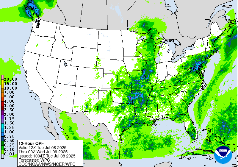
Excessive Rainfall Discussion
NWS Weather Prediction Center College Park MD
520 AM EDT Tue Jul 8 2025
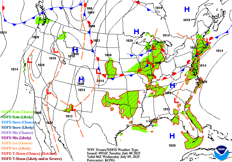
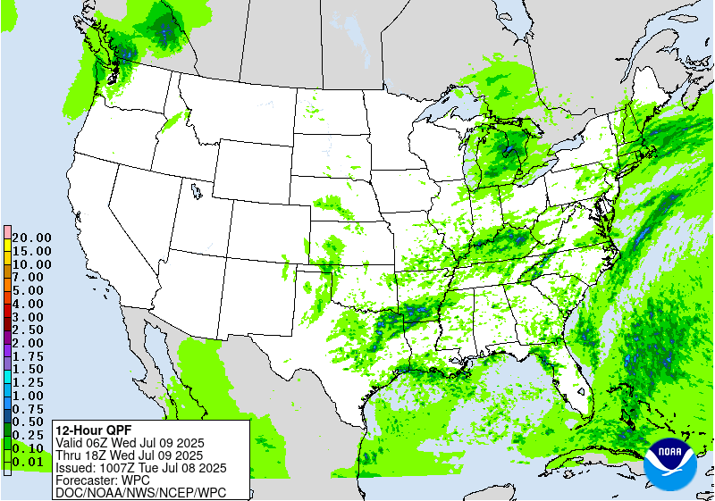
Day 1
Valid 12Z Tue Jul 08 2025 - 12Z Wed Jul 09 2025
...THERE IS A SLIGHT RISK OF EXCESSIVE RAINFALL FOR MUCH OF THE
EASTERN MID-ATLANTIC STATES AND SOUTHERN NEW ENGLAND, AS WELL AS
FOR PARTS OF THE ARKANSAS AND RED RIVER VALLEY AND ADJACENT OZARKS
AND OUACHITA MOUNTAINS...
...Mid-Atlantic and Northeast...
The remnants of post-tropical cyclone Chantal are in the process of
transitioning into an open trough while exiting east of Cape Cod
to start the period, as it continues to get caught up in increasing
southwesterlies downstream of a trough approaching from the Great
Lakes. This trough will continue to translate eastward through the
day, but will be slow to advect due to downstream Bermuda-type
ridging. Between these two features, southwest flow will remain
prevalent over the area, with 850-500mb winds being nearly
unidirectional from the W/SW at 15-20 kts. This will result in a
continued extremely moist environment with PWs likely eclipsing 2"
from eastern VA through southern New England Tuesday afternoon,
coincident with a plume of SBCAPE exceeding 2000 J/kg (per 00z HREF
mean fields).
Into these impressive thermodynamics, a subtle shortwave embedded
within the mean flow will traverse northeast ahead of a cold front
and along a surface trough, providing additional ascent atop the
already impressive convergence on these boundaries. The 00z hi-res
CAM consensus suggests showers and thunderstorms will become
numerous to widespread along and near the front during the mid to
late afternoon, and storm motions are expected to initially be
quite slow (0-1 km mean flow near 10 kts) with the potential for
localized backbuilding and training along the surface trough and
front (as Corfidi vectors collapse to around 5 kts with the
development of deep convection and resulting outflow boundaries).
With warm cloud depths potentially eclipsing 14,000 ft, this will
support efficient warm-rain processes and rain rates above 2"/hr
at times (and resulting localized hourly totals of 1-2"). Where
training occurs, this could result in total rainfall in excess of
3" (per 00z HREF 40-km neighborhood 3" exceedance probabilities
ranging from 10-40% across the SLGT risk area). Scattered
instances of flash flooding are possible across much of the I-95
corridor from Richmond, VA to Boston, MA.
...Southern Plains through the Ohio Valley...
A wavering front will press eastward from Oklahoma through Ohio
today, providing forcing for ascent through low-level convergence.
This frontal convergence will work in tandem with subtle height
falls as the driving trough pushes south and east, and modest PVA
as spokes of vorticity rotate eastward through the flow. While in
general this will result in scattered thunderstorms developing
along the front with rainfall rates of 1+"/hr, hi-res models have
come into better agreement in indicating a maxima of organizational
potential in the vicinity of the Ozarks and Ouachita Mountains (and
surrounding Arkansas and Red River Valleys). An inherited SLGT risk
in this region was maintained (and adjusted a bit based on the new
guidance).
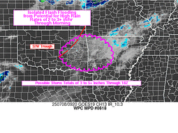
In this portion of the Southern Plains and into the Lower MS Valley,
a shortwave (and a mature/waning MCS) is digging southward this
morning, which may drive locally enhanced ascent and subsequent
initiation and organization of convection as early as this morning
through late afternoon/evening. PWs are already 1.8-2.0" in this
region, and a 20 kt LLJ is providing modest moisture transport with
500-1500 J/kg of SBCAPE already in place (forecast to increase to
as high as 2000-3000 J/kg with daytime heating, per 00z HREF mean
and ens max). While antecedent conditions are relatively dry (below
average rainfall over the past 7 days) with 3-hr Flash Flood
Guidance (FFG) ranging from 3-4", soil moisture is still indicated
to be generally well above normal (per NASA SPoRT 0-40cm and
0-100cm anomalies near or above 90th percentile) with streamflows
in the region near normal to above normal (per USGS data). The SLGT
risk generally encompasses where probs for localized 5" exceedance
are highest (per 40-km neighborhood probs from the HREF and
experimental REFS ranging from 20-30%).
Farther north near the base of the trough (into MO/IL), an MCV has
the potential to locally organize convection with better overall
dynamics (DPVA and shear from right-entrance region of jet streak)
compared to farther south (despite overall tropospheric moisture
likely to remain a bit lower with PWs less than 2.0" (but still at
or above 90th percentile). CAMs are not as aggressive with this
area, but will need to be monitored closely today given the MCV
and added daytime instability (HREF indicating SBCAPE rising to
1500-2500 J/kg).
...Upper Midwest...
A wave of low pressure and accompanying surface trough will move
progressively eastward from Minnesota into Michigan the first half
of today. While this will be generally fast moving, it will
impinge into a favorable environment to support heavy rain rates
which will likely eclipse 1"/hr, especially where it overlaps a
ribbon of MUCAPE reaching 1000-2000 J/kg. The fast motion will
limit total rainfall, but in some places that receive multiple
rounds of heavy rain, event totals could reach 2-3". This falling
atop sensitive soils (FFG as low as 1-1.5"/3hrs) could produce
localized instances of flash flooding.
......Southeastern New Mexico...
Another daily round of showers and thunderstorms is expected to
develop in the high terrain and then drop southeast into the High
Plains and southeastern portions of New Mexico. Although storms
are expected to be generally progressive as they come off the
terrain (0-6km mean winds from the north around 15 kts), they will
move into an axis of more favorable thermodynamics characterized by
PWs of above 1" and MUCAPE approaching 1000 J/kg. This could
support briefly heavy rain rates above 1"/hr, supporting an
isolated risk for flash flood impacts across urban areas or
sensitive terrain and burn scars.
Churchill/Weiss
Day 1 threat area:
www.wpc.ncep.noaa.gov/qpf/94epoints.txt
Excessive Rainfall Discussion
NWS Weather Prediction Center College Park MD
520 AM EDT Tue Jul 8 2025
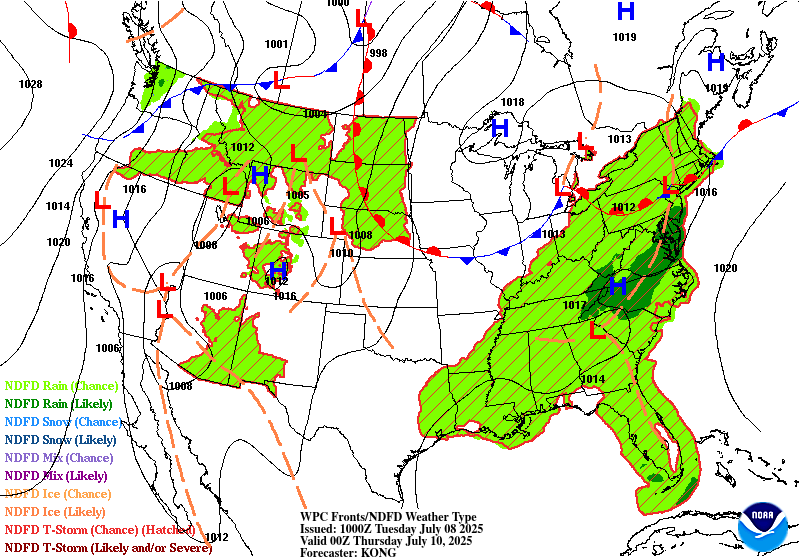
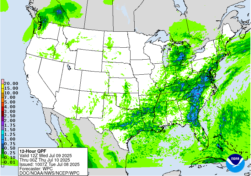
Day 2
Valid 12Z Wed Jul 09 2025 - 12Z Thu Jul 10 2025
...THERE IS A SLIGHT RISK OF EXCESSIVE RAINFALL FOR THE EASTERN
MID-ATLANTIC STATES...
...Mid-Atlantic...
Quasi-stationary front from Tuesday will linger in a general east-
to-west fashion on Wednesday across the Mid-Atlantic States. Along
this boundary, a much more potent shortwave (likely enhanced in the
latest guidance from the aforementioned MCV currently in the
Plains) will press east within the approaching longwave trough,
leading to weak low pressure development moving east along this
front. The accompanying ascent will act favorably into continued
robust thermodynamics with PWs around 2 inches (above the 90th
percentile according to NAEFS ensemble tables) and 1000-3000 J/kg
SBCAPE during the afternoon. Increasing 0-6km bulk shear and
aligned 0-6km mean winds to the front suggests storms will
repeatedly develop to the SW and then train ENE across the Mid-
Atlantic states. Not only will this result in heavy rainfall which
may exceed 3 inches in some areas, but it will occur across primed
soils from heavy rainfall on prior days, enhancing the flash flood
risk. An inherited SLGT risk was maintained and expanded based on
the new guidance, and high-end (25%+) SLGT probabilities are
indicated from central NC through much of VA and into southern MD.
Upon the full evaluation of the new 12z CAM suite later today, a
targeted upgrade to MOD risk may be necessary for portions of the
SLGT risk (particularly given the more vulnerable antecedent
conditions).
...Central Texas through the Southern Ohio Valley...
Stalled frontal boundary will gradually begin to lift northeast on
Wednesday over the OH Valley, but persistent ascent along this
front as weak shortwaves cross it will maintain a convective risk
through the day. Some DPVA and subsequent forcing for ascent from
storms in the Plains may be deflected southward into the warm,
moist air mass of the Southern Plains (possibly as far south as
more vulnerable areas of central TX). Storms will fire in response
to thermodynamics characterized by PWs around 2 inches collocated
with SBCAPE during peak heating that will approach 2000 J/kg. While
convection is likely to be scattered, any storm which trains along
the boundary with intense 1-2"/hr rain rates may result in rapid
runoff capable of producing instances of flash flooding (with
training/repeating of efficient rates less likely into the Plains
and Lower MS Valley, but will come down to mesoscale details that
are difficult to discern in the 24-48 hour timeframe).
Churchill/Weiss
Day 2 threat area:
www.wpc.ncep.noaa.gov/qpf/98epoints.txt
Excessive Rainfall Discussion
NWS Weather Prediction Center College Park MD
520 AM EDT Tue Jul 8 2025
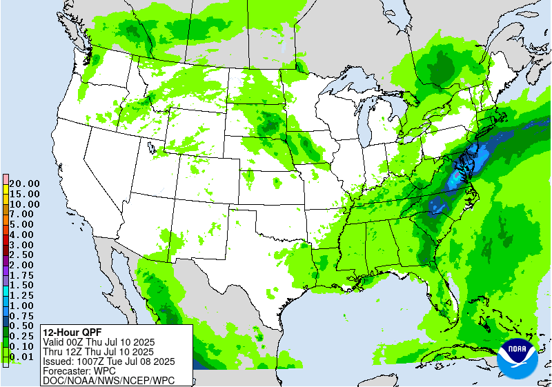
Day 3
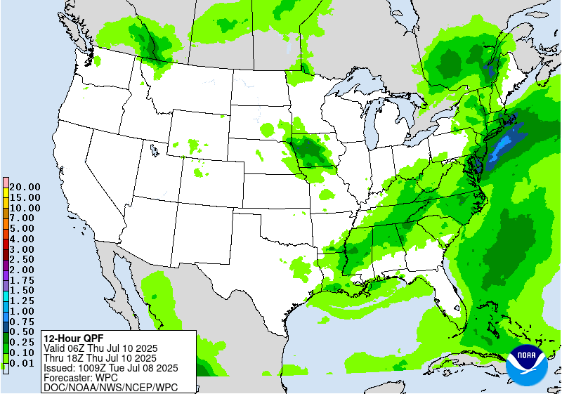
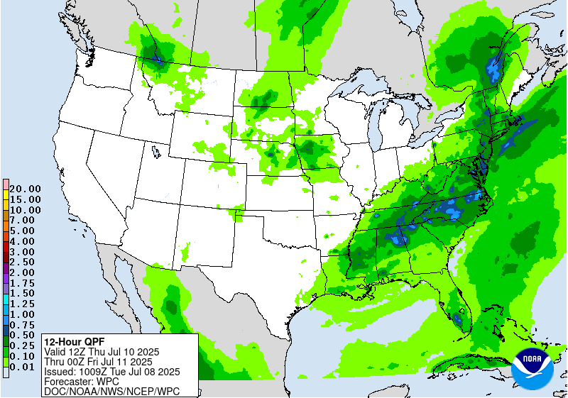
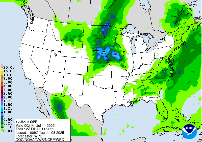
Valid 12Z Thu Jul 10 2025 - 12Z Fri Jul 11 2025
...THERE IS A SLIGHT RISK OF EXCESSIVE RAINFALL FOR PORTIONS OF THE
CENTRAL MID-ATLANTIC STATES, AS WELL AS FOR PORTIONS OF THE CENTRAL
PLAINS AND UPPER MIDWEST...
...Tennessee Valley into the Mid-Atlantic and New England...
A warm and anomalously moist air mass looks to remain in place
across much of the Southeast and Eastern U.S. into Thursday
continuing a broad flash flood threat into yet another day.
Although upper-level forcing looks less impressive overall relative
to Wednesday, still expect another round of primarily diurnally
driven convection focused along the terrain and associated leeward
trough of the Appalachians, perhaps becoming best organized a bit
farther south than prior days as the combination of best forcing
and moisture/instability looks concentrated across the southern
Mid-Atlantic into portions of the Southeast. Maintained an
inherited SLGT risk area for more vulnerable portions of central NC
and surrounding far south-central VA, but this area will likely be
modified over subsequent forecast cycles with dependencies on both
trends in the guidance and how the forecast ultimately pans out for
days 1 and 2 (as antecedent conditions will be a big factor). The
latest trends in the guidance suggest the threat will be more muted
from much of VA northward (with subtle height rises aloft from
sub- tropical ridging tries to offset the more favorable parameter
space for heavy rainfall).
...Northern and Central Plains into the Upper Midwest...
By Thursday the persistent ridge aloft over the Southwest U.S.
begins to break down, as an upper-low off the northern CA coast
opens up into a shortwave trough on Wednesday and ejects eastward
ahead of a digging longwave trough over western Canada. These two
features look to interact over the Northern and Central Plains, but
there are still substantial differences between models in how these
features evolve and interact. Maintained an inherited SLGT risk
area in the vicinity of where the best QPF signal overlaps (west-
central IA into adjacent portions of NE/SD/MN), but this area is
likely to shift over the coming days as models find a better
consensus of where organized convection is most likely to occur.
Regardless of where exactly this occurs, PWs of 1.5"+ are expected
(near or above 90th percentile for the region) with ample
instability and dynamics for organized convection and subsequent
high rainfall rates.
Churchill
Day 3 threat area:
www.wpc.ncep.noaa.gov/qpf/99epoints.txt
Extended Forecast Discussion
NWS Weather Prediction Center College Park MD
225 AM EDT Tue Jul 8 2025
Scattered convection anticipated to fire ahead of, and along
progressive
cold fronts, stalled boundaries and round the upper high in the
Southern Rockies. The exact location of anticipated higher QPF
amounts remain a bit uncertain given persistent model differences,
nevertheless, there is potential for isolated instances of
excessive rainfall and localized flash flooding-- including areas
from the Corn Belt into the Midwest and Ohio Valley, Appalachians,
and Mid-Atlantic.
For Day 4, there is broad Marginal Risk area for the Upper
Mississippi Valley/Midwest, a broad Marginal Risk stretching from
interior portions of the Deep south to the Mid- Atlantic coast, and
a Marginal Risk covering portions of eastern Colorado, Kansas,
Oklahoma and Texas Panhandle. For Day 5, there is a Marginal Risk
for eastern New Mexico and parts of the Oklahoma/Texas Panhandles
and from the Central/Southern Plains to southern portions of the
Northeast/Maryland.
Many locations will have daily maximums climbing well into the
100s at lower elevations across the Southwest and mainly dry
conditions, except for perhaps far southeastern Arizona into New
Mexico where some monsoonal moisture may be present. Experimental
HeatRisk values may rise to Major or Extreme levels (3 out of 4 or
4 out of 4) from the California deserts into southern Nevada, Utah,
and Arizona. Extreme Heat Watches have been raised for parts of
Arizona and Nevada through at least Thursday and several Extreme
Heat Warnings are in effect from southern California to eastern
Arizona.
Campbell/Hamrick


