Excessive Rainfall Discussion
NWS Weather Prediction Center College Park MD
357 PM EDT Mon Jul 7 2025
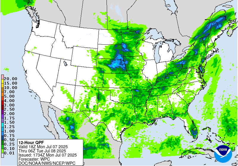
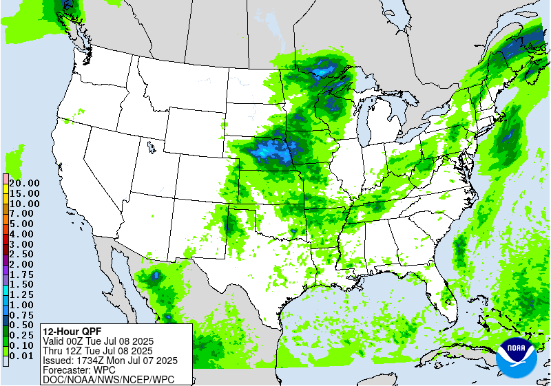
Day 1
Valid 16Z Mon Jul 07 2025 - 12Z Tue Jul 08 2025
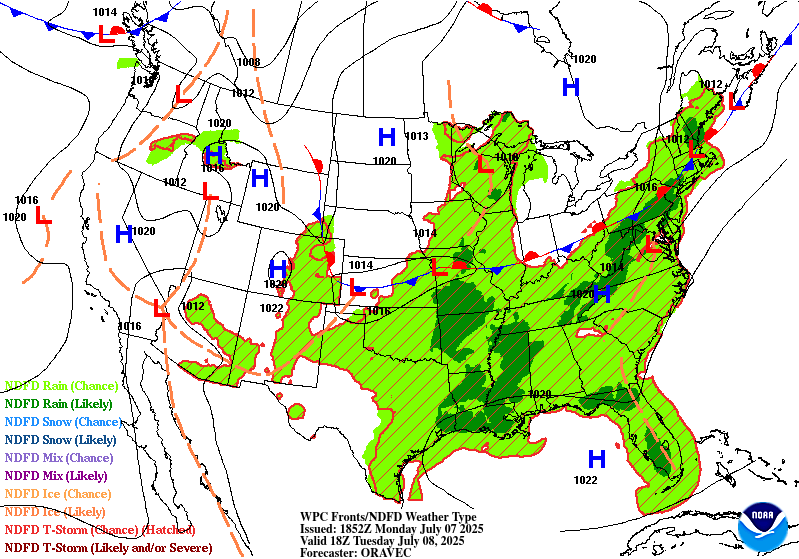
...THERE IS A MODERATE RISK OF EXCESSIVE RAINFALL ACROSS PORTIONS
OF THE HILL COUNTRY OF TEXAS...
...South Central Texas...
After coordination with WFOs San Antonio and San Angelo (Texas),
this special update was created to add a targeted MDT risk for
portions of the Texas Hill Country. Although morning CAMs (pre-12Z
runs) are struggling to resolve the current activity, there is
enough signal, despite timing and placement differences, in the
guidance that concern is elevated for a MDT risk.
A 700mb trough aligned SW to NE will string out across central
Texas through today and remain nearly in place through the evening.
Into this trough, impressive convergence will focus as return flow
emerges out of the Gulf while NW flow concurrently progresses from
the Southern Rockies. Not only will this force ascent, but
examination of CIRA ALPW percentiles reveals that elevated PW
in the low levels (sfc-850mb above the 95th percentile) shifting
NW while PWs in the 700-500mb layer also above the 95th percentile
drop SE. This will force intense moisture confluence into this
trough axis, and the result is very weak 0-6km mean winds of just 5
kts with anti-parallel Corfidi vectors of 10-15 kts. This suggests
that as convection blossoms during the next few hours storms
should move slowly and generally drift W/SW across the Hill
Country. This results in both HREF and REFS probabilities that
reach 60% and 30%, respectively (06Z runs) for 5" of rainfall
through the evening, despite uncertainty in the individual CAMs.
Rainfall already this morning has been expanding with radar-
estimated rainfall rates above 3"/hr, and as instability climbs
this aftn, expect these rain rates to continue as PWs remain above
2 inches. These slow moving storms with these intense rain rates
will additionally move atop extremely vulnerable soils due to 72-hr
rainfall that has been 5-15", causing catastrophic flash flooding
over the weekend and resulting in saturated 0-10cm RSM from NASA
SPoRT and FFG below 2"/3hrs. Any storms that move across this
extremely vulnerable region will rapidly cause flash flooding, some
of which could be significant if cells repeat or stall over the
already hard-hit regions.
...Mid-Atlantic...
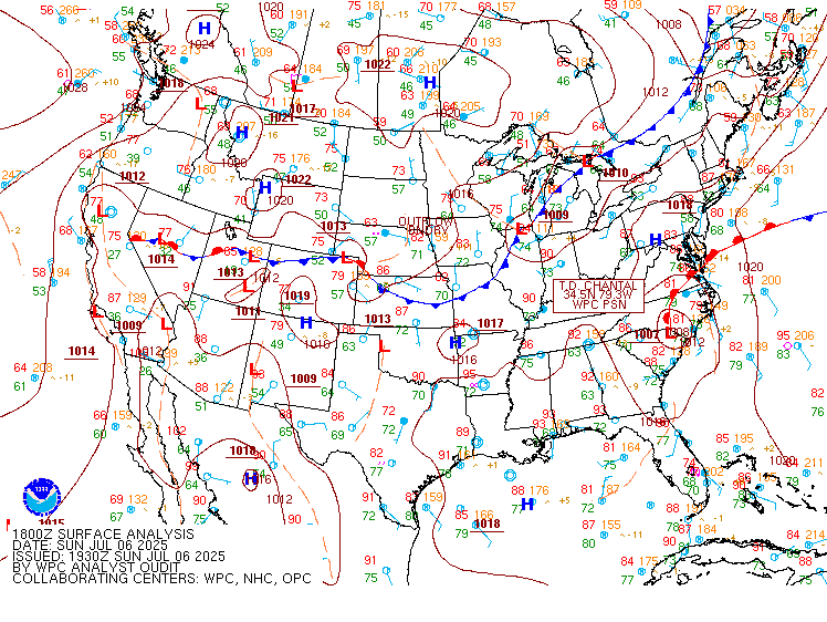
Post Tropical Cyclone Chantal, currently centered over southeast
Virginia will gradually accelerate northeastward this afternoon as
it gets picked up by an approaching longwave trough from the west.
Despite the slow acceleration, significant rainfall is still likely
along and north of the track which could result in flash flooding
through tonight.
As Chantal lifts northeast, the accompanying tropical environment
will advect with it. PWs measured via 12Z U/A soundings were near
daily records at both IAD and OKX, with deep saturation noted
through and above 500mb. This will support extremely efficient rain
rates in the vicinity of Chantal today, with 2+"/hr rates probable
(>50%) along and east of the track of this weakening depression. As
instability climbs this afternoon, convective coverage near Chantal
will expand as reflected by the available CAMs, and there may be
two areas of maximum rainfall today. The first will be along the
track of Chantal where the efficient rain rates driven by warm rain
collision processes will train through weak Corfidi vectors and
850mb inflow that may exceed the otherwise weak mean 0-6km winds.
Additionally, there is likely to be an axis of heavy rain extending
northeast from Chantal where onshore S/SE flow impinges into a
surface trough driving strong mass convergence and moisture
confluence. Storms along this boundary will likely regenerate and
train to the northeast, providing additional focus for an axis of
heavy rainfall.
With rain rates expected to peak above 2"/hr, there is likely to be
a corridor of rainfall today exceeding 3" (60%+ chance from both
HREF and REFS) with locally above 5" possible as reflected by
20-30% probabilities and 20-hr PMMs. The greatest risk for the
heaviest rainfall appears to be focused from the DelMarVa northeast
through NJ and southern Upstate NY. The slight risk was adjusted
cosmetically across this area, and locally some higher-end slight
risk type impacts are possible, especially for eastern MD/DE this
aftn, where training along the surface trough will be followed by
the center of Chantal, enhancing the rainfall and flash flood
risk.
...Northeast back into the Ozarks...
Broad 500mb trough extending from New England back into the Mid-
South will push a cold front steadily southeast today before
stalling tonight. This front is progged to reach as far as eastern
Maine before D2, angling SW through the eastern Ohio Valley and
Mid-Mississippi Valley. Along this front, a weak shortwave will
lift northeast along the low-level baroclinic gradient, with at
least modest upper diffluence from the distant tail of an upper jet
streak also providing ascent.
The result of this setup will be broad but locally impressive deep
layer lift from Arkansas through Maine, leading to scattered to
numerous thunderstorms developing during the afternoon/evening.
These thunderstorms will blossom within a corridor of robust
thermodynamics characterized by PWs of 1.75 to 2 inches, or as much
as +2.5 sigma according to GEFS standardized anomalies, overlapping
MUCAPE of 1000-2000 J/kg. This will support rain rates that have a
high chance (40-70%) of exceeding 1"/hr, with locally higher than
2"/hr also possible.
There remains some concern about the coverage of convection today
as the CAMs are generally modest and inconsistent. However, the
overlap of impressive deep layer lift into the strong PW/CAPE
should support at least scattered, if not numerous thunderstorms
today. With rain rates likely reaching 1-2"/hr and training
expected along the front, this could result in instances of flash
flooding anywhere along the boundary. There appears to be a locally
higher risk from eastern Ohio into Upstate New York where training
may be more impressive and bulk shear reaches 25 kts to support
more organization than along other portions of the front. This is
also where the HREF and REFS 3"/24hr and 5"/24 hr probabilities
peak, so the inherited SLGT risk was just adjusted cosmetically
across this area.
There is also the potential for some higher rainfall over the
Ozarks where the CAMs suggest the potential for some more organized
convection tonight on the tail end of the front as it stalls over
northern AR. This could be collocated with a weak shortwave moving
through the flow and the increasing 850mb LLJ which, while
remaining of modest intensity 15-20 kts, could lead to some
impressive convergence to enhance and temporally extend rainfall.
At this time, confidence is not high enough for an upgrade, but
this area will need to be monitored for a possible SLGT risk later
today/tonight.
...Northern Plains and Upper Midwest to the Central Plains...
A mid-level trough axis will push across the Northern Plains this
evening, reaching the Upper Midwest by the end of D1. This will
drive a surface cold front south and a wave of low
pressure/surface trough east at the same time. Additional ascent
will be provided by a modest jet streak pivoting across the
northern Great Lakes, but with well aligned RRQ diffluence atop the
eastward translating trough axis. This ascent will impinge into a
moistening column where 850mb inflow from the S/SW reaches 15-20
kts, driving PWs to above 1.5", or around +1 sigma above the
climatological mean.
Convection that arises from this evolution will have the potential
to produce rainfall rates above 1"/hr, with organization into
clusters likely as 0-6km bulk shear rises to 30-40 kts. 0-6km mean
winds of 15-25 kts aligned with rapid Corfidi vectors which are
generally perpendicular to the boundary suggest training will be
minimal and the fast motion should limit the overall flash flood
risk. However, locally enhanced training along any outflows or
cluster boundaries could cause isolated heavier rainfall exceeding
3 inches in a few areas, with a locally higher potential for this
across parts of Nebraska. However, at this time confidence is not
high enough for any upgrades as these higher probabilities in
general lay atop drier soils with higher infiltration capacity.
Still, these intense rain rates could cause at least isolated
impacts anywhere within the MRGL risk area today and tonight.
...Southwest and Southern Rockies/High Plains...
Isolated to scattered showers and thunderstorms will develop around
the periphery of a mid-level ridge today, blossoming across CO and
NM before shifting southeast through the day. Although coverage is
not expected to be widespread, any showers and thunderstorms that
develop could produce briefly heavy rain rates above 0.5-1"/hr,
with motions initially slow during development, especially across
higher terrain features. Eventually, storms should move more
progressively S/SE off the terrain, limiting the overall flash
flood risk. However, should any slow moving storm (during
initiation) or faster cell with intense rain rates move atop
sensitive terrain or vulnerable burn scars, isolated instances of
flash flooding could result.
Weiss
Day 1 threat area:
www.wpc.ncep.noaa.gov/qpf/94epoints.txt
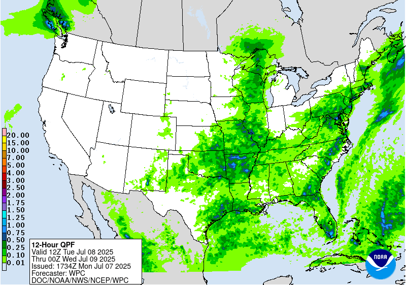
Excessive Rainfall Discussion
NWS Weather Prediction Center College Park MD
357 PM EDT Mon Jul 7 2025
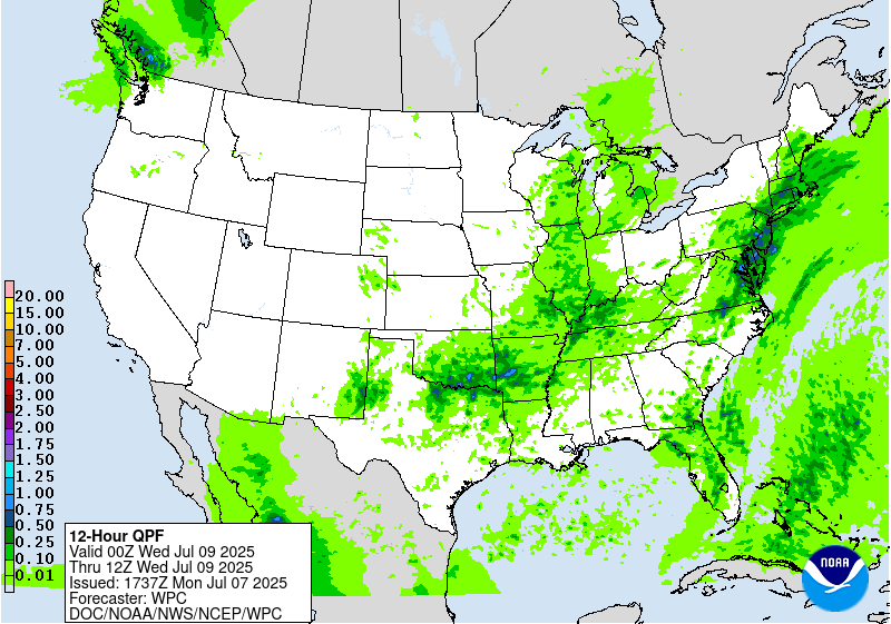
Day 2
Valid 12Z Tue Jul 08 2025 - 12Z Wed Jul 09 2025
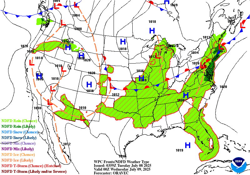
...THERE IS A SLIGHT RISK OF EXCESSIVE RAINFALL FOR THE EASTERN
MID-ATLANTIC STATES AND SOUTHERN NEW ENGLAND, AS WELL AS PARTS OF
THE SOUTHERN PLAINS...
...Mid-Atlantic and Northeast...
Post-tropical cyclone Chantal will be exiting east of Cape Cod to
start the period as it continues to get caught up in increasing
southwesterlies downstream of a trough approaching from the Great
Lakes. This trough will continue to translate eastward through the
day, but will be slow to advect due to downstream Bermuda-type
ridging. Between these two features, SW flow will remain prevalent
over the area, with 850-500mb winds being nearly unidirectional
from the W/SW at 15-20 kts. This will result in a continued
extremely moist environment with PWs likely eclipsing 2" from
eastern VA through southern New England Tuesday afternoon,
coincident with a plume of SBCAPE exceeding 2000 J/kg.
Into these impressive thermodynamics, a shortwave embedded within
the mean flow will traverse northeast ahead of a cold front and
along a surface trough, providing additional ascent atop the
already impressive convergence on these boundaries. This suggests
showers and thunderstorms will become widespread, which is
additionally supported by high-res CAM simulated reflectivity.
Storms that develop will move very slowly, and Corfidi vectors
collapsed to just around 5 kts will support backbuilding and
training echoes along the surface trough and front. With warm cloud
depths potentially eclipsing 14,000 ft, this will support efficient
warm-rain processes and rain rates above 2"/hr at times. Where
training occurs, this could result in total rainfall in excess of
3", with instances of flash flooding possible across much of the
I-95 corridor from Richmond, VA to Portland, ME, and a slight risk
has been added for this area.
...Southern Plains through the Ohio Valley...
A wavering front will press eastward from Oklahoma through Ohio
during Tuesday, providing forcing for ascent through low-level
convergence. This frontal convergence will work in tandem with
subtle height falls as the driving trough pushes south and east,
and modest PVA as spokes of vorticity rotate eastward through the
flow. While in general this will result in scattered thunderstorms
developing along the front with rainfall rates of 1+"/hr, there may
be a localized maxima of heavy rain potential from eastern OK into
northern AR.
In this portion of the Southern Plains and into the Ozarks, an
impressive shortwave is progged to push southward Tuesday evening/night
and suppress the ridge to the west. This will drive locally
enhanced ascent. At the same time, lingering boundaries from Monday
night's convection and scattered storms earlier on Tuesday will
provide additional focus, and the CAMs, while differing spatially
and temporally, suggest locally more organized convection Tuesday
night. As this shortwave drops south and interacts with surface
boundaries, it will impinge into increasingly robust thermodynamics
as the 20 kt LLJ pushes PWs to around 2 inches coincident with
MUCAPE surging to 2000 J/kg. The HREF hourly rain rate
probabilities for 2"/hr peak around 20% during this time,
suggesting intense rainfall that could overwhelm soils and produce
runoff, especially where backbuilding/training occurs due to
Corfidi vectors aligning against the mean wind. Additionally some
enhanced shear during this time could organize convection into an
MCS, leading to even more impressive rain rates. Although
confidence is modest in the exact timing and placement, both the
HREF and REFS have increased probabilities for 3" (60%) and 5"
(30%) of rainfall, leading to the upgraded SLGT risk area.
...Upper Midwest...
A wave of low pressure and accompanying surface trough will move
progressively eastward from Minnesota into Michigan the first half
of Tuesday. While this will be generally fast moving, it will
impinge into a favorable environment to support heavy rain rates
which will likely eclipse 1"/hr, especially where it overlaps a
ribbon of MUCAPE reaching 1000-2000 J/kg. The fast motion will
limit total rainfall, but in some places that receive multiple
rounds of heavy rain, event totals could reach 2-3". This falling
atop sensitive soils (FFG as low as 1-1.5"/3hrs) could produce
instances of flash flooding.
......Southern New Mexico...
Another daily round of showers and thunderstorms is expected to
develop in the high terrain and then drop southeast into the High
Plains and southern portions of New Mexico. Although storms are
expected to be generally progressive as they come off the terrain
(0-6km mean winds from the north around 15 kts), they will move
into an axis of more favorable thermodynamics characterized by PWs
of above 1" and MUCAPE approaching 1000 J/kg. This could support
briefly heavy rain rates above 1"/hr, supporting an isolated risk
for flash flood impacts across urban areas or sensitive terrain and
burn scars.
Weiss
Day 2 threat area:
www.wpc.ncep.noaa.gov/qpf/98epoints.txt


