Excessive Rainfall Discussion
NWS Weather Prediction Center College Park MD
1135 AM EDT Tue Jul 8 2025
Day 1
Valid 16Z Tue Jul 08 2025 - 12Z Wed Jul 09 2025
...THERE IS A SLIGHT RISK OF EXCESSIVE RAINFALL FOR MUCH OF THE
EASTERN MID-ATLANTIC STATES AND SOUTHERN NEW ENGLAND, AS WELL AS
FOR PARTS OF THE ARKANSAS AND EASTERN OKLAHOMA...
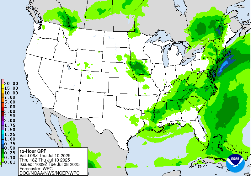
...Mid-Atlantic and Northeast...
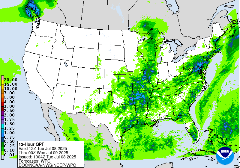
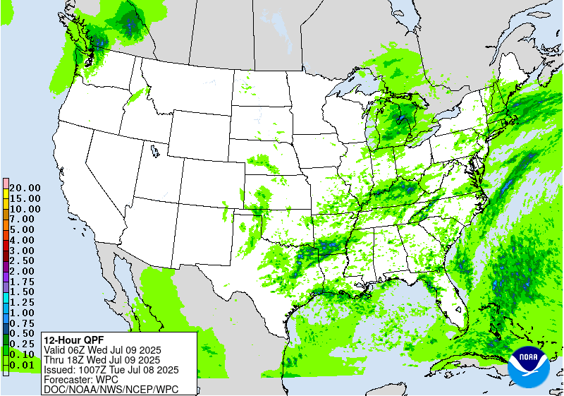
16Z Update: The overall synoptic and mesoscale scheme are still
relevant from previous forecast, although one note to point out is
the increasing potential for more locally enhanced flash flood
concerns focused across portions of Southeast VA. 12z CAMs are much
more bullish on the area between I-95 to the mouth of the Potomac
in VA for the highest precip output in the period. A lot of the
setup is driven by the training prospects in the vicinity of
Richmond through Williamsburg up to the areas running adjacent to
the Rappahannock River. 12z HREF neighborhood probs are running
between 40-60% for >3", but between 60-80% for >2" leading to a
strengthening signal compared to previous forecast output as noted
in the previous discussion below. This aligns with the increased
low-level convergence pattern as the mean layer wind becomes
generally unidirectional after 00z across Central and Southeast VA
with the approach of a shortwave expected to eject out of
Southwest VA. With coordination from the local Wakefield, VA WFO,
have expanded the SLGT risk into all of Southeast VA to account for
the threat.
Further north into the Megalopolis of the Mid Atlantic and
Northeast, the best threat for heavy rainfall will likely be
situated over Southern New England down into NYC where a secondary
focus will occur as a shortwave analyzed over Western PA lifts to
the east-northeast and centers over the above zone by later this
evening. Environment remains favorable for locally stronger
convective cores to produce rainfall rates in excess of 1"/hr,
especially with the assessment of 12z KOKX PWATs coming in ~2", a
reading encroaching the 30-day moving max, and eclipsing the daily
max for the 8th. The high urbanization factor always constitutes
close monitoring for locally impactful flash flooding, so the
threat remains well within the threshold for a SLGT risk leading to
general continuity for the forecast.
Kleebauer
..Previous Discussion..
The remnants of post-tropical cyclone Chantal are in the process of
transitioning into an open trough while exiting east of Cape Cod
to start the period, as it continues to get caught up in increasing
southwesterlies downstream of a trough approaching from the Great
Lakes. This trough will continue to translate eastward through the
day, but will be slow to advect due to downstream Bermuda-type
ridging. Between these two features, southwest flow will remain
prevalent over the area, with 850-500mb winds being nearly
unidirectional from the W/SW at 15-20 kts. This will result in a
continued extremely moist environment with PWs likely eclipsing 2"
from eastern VA through southern New England Tuesday afternoon,
coincident with a plume of SBCAPE exceeding 2000 J/kg (per 00z HREF
mean fields).
Into these impressive thermodynamics, a subtle shortwave embedded
within the mean flow will traverse northeast ahead of a cold front
and along a surface trough, providing additional ascent atop the
already impressive convergence on these boundaries. The 00z hi-res
CAM consensus suggests showers and thunderstorms will become
numerous to widespread along and near the front during the mid to
late afternoon, and storm motions are expected to initially be
quite slow (0-1 km mean flow near 10 kts) with the potential for
localized backbuilding and training along the surface trough and
front (as Corfidi vectors collapse to around 5 kts with the
development of deep convection and resulting outflow boundaries).
With warm cloud depths potentially eclipsing 14,000 ft, this will
support efficient warm-rain processes and rain rates above 2"/hr
at times (and resulting localized hourly totals of 1-2"). Where
training occurs, this could result in total rainfall in excess of
3" (per 00z HREF 40-km neighborhood 3" exceedance probabilities
ranging from 10-40% across the SLGT risk area). Scattered
instances of flash flooding are possible across much of the I-95
corridor from Richmond, VA to Boston, MA.
Churchill
...Southern Plains through the Ohio Valley...
16Z Update: A targeted area across Eastern OK into Western AR now
exists as a higher-end SLGT with some locally significant impacts
plausible over the aforementioned area. Current WV satellite and UA
analysis depicts a prevalent mid-level shortwave located within the
confines of Northeast OK and Southeast KS dipping southeast over
the last several hrs. Enhanced sfc-500mb convergence pattern over
Eastern OK to the AR/OK line is already materializing with a
solidified low-level inflow pattern advecting unstable air into the
vicinity of the mid-level circulation. Latest RAP surface analysis
pins a target of 1000-2000 J/kg of SBCAPE located over the axis of
greatest convergence with PWATs noted to be ~2" as 12z KLZK
sounding just to the east depicted a PWAT observation of 1.99",
above the 90th percentile daily output. The combination of a
pronounced area of buoyancy and focused surface convergence on the
southern flank of the shortwave will create an opportunity for
locally enhanced hourly rates between 2-3+"/hr through the next 3-6
hrs before the threat wanes with the progression of the shortwave
migrating eastward. For more information on this threat, please see
MPD #0619 for the latest.
More convection will fire this evening across Southern MO with the
strongest cells likely to induce some 2-3"/hr rates for a short
time, enough to warrant some attention for flash flood prospects
across the Ozarks due to the local topography. The SLGT risk was
expanded to include those areas where 12z CAMs have highlighted the
potential.
No additional changes were made across the Midwest and Mid-
Mississippi Valley, but will monitor the progression and expected
output from the MCV as it migrates into IL this afternoon and
evening. Some spots may see 2-4" of rainfall which could very well
induce flash flooding, especially in any urbanized areas where run
off prospects are highest, generally in-of and between St. Louis to
Springfield, IL.
Kleebauer
..Previous Discussion..
Farther north near the base of the trough (into MO/IL), an MCV has
the potential to locally organize convection with better overall
dynamics (DPVA and shear from right-entrance region of jet streak)
compared to farther south (despite overall tropospheric moisture
likely to remain a bit lower with PWs less than 2.0" (but still at
or above 90th percentile). CAMs are not as aggressive with this
area, but will need to be monitored closely today given the MCV
and added daytime instability (HREF indicating SBCAPE rising to
1500-2500 J/kg).
Churchill
...Upper Midwest...
16Z Update: No changes to the previous forecast as the general
synoptic and mesoscale pattern remains on track with little run to
run deviation.
Kleebauer
..Previous Discussion..
A wave of low pressure and accompanying surface trough will move
progressively eastward from Minnesota into Michigan the first half
of today. While this will be generally fast moving, it will
impinge into a favorable environment to support heavy rain rates
which will likely eclipse 1"/hr, especially where it overlaps a
ribbon of MUCAPE reaching 1000-2000 J/kg. The fast motion will
limit total rainfall, but in some places that receive multiple
rounds of heavy rain, event totals could reach 2-3". This falling
atop sensitive soils (FFG as low as 1-1.5"/3hrs) could produce
localized instances of flash flooding.
Churchill
......Southeastern New Mexico...
16Z Update: The pattern remains favorable for another diurnally
driven convective pattern in-of the terrain of NM, especially in
the confines of the Sacramento Mtns. up to the Sandia's to the east
of ABQ. No changes were necessary from the previous forecast MRGL
risk issuance.
Kleebauer
..Previous Discussion..
Another daily round of showers and thunderstorms is
expected to develop in the high terrain and then drop southeast
into the High Plains and southeastern portions of New Mexico.
Although storms are expected to be generally progressive as they
come off the terrain (0-6km mean winds from the north around 15
kts), they will move into an axis of more favorable thermodynamics
characterized by PWs of above 1" and MUCAPE approaching 1000 J/kg.
This could support briefly heavy rain rates above 1"/hr, supporting
an isolated risk for flash flood impacts across urban areas or
sensitive terrain and burn scars.
Churchill/Weiss
Day 1 threat area:
www.wpc.ncep.noaa.gov/qpf/94epoints.txt
Excessive Rainfall Discussion
NWS Weather Prediction Center College Park MD
1135 AM EDT Tue Jul 8 2025
Day 2
Valid 12Z Wed Jul 09 2025 - 12Z Thu Jul 10 2025
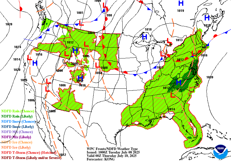
...THERE IS A SLIGHT RISK OF EXCESSIVE RAINFALL FOR THE EASTERN
MID-ATLANTIC STATES...
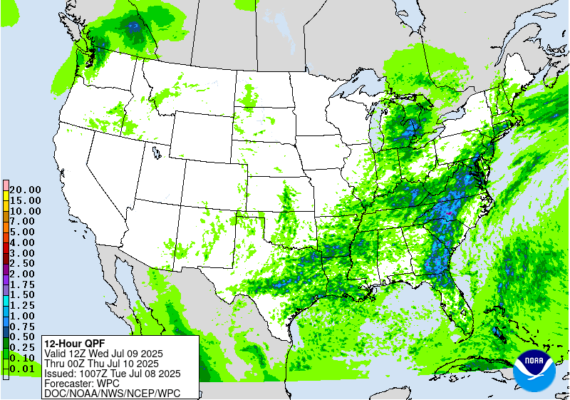
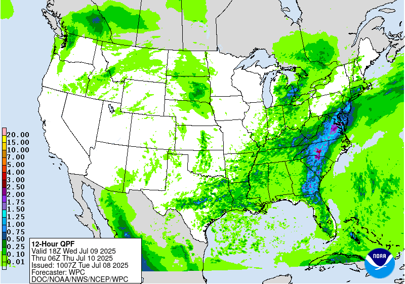
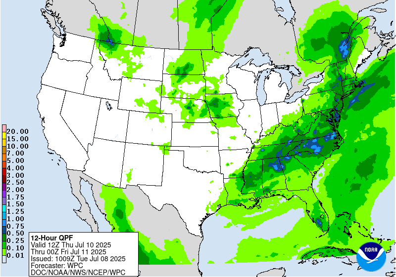
...Mid-Atlantic...
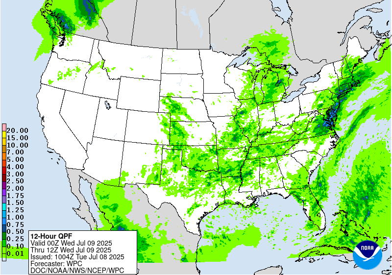
Quasi-stationary front from Tuesday will linger in a general east-
to-west fashion on Wednesday across the Mid-Atlantic States. Along
this boundary, a much more potent shortwave (likely enhanced in the
latest guidance from the aforementioned MCV currently in the
Plains) will press east within the approaching longwave trough,
leading to weak low pressure development moving east along this
front. The accompanying ascent will act favorably into continued
robust thermodynamics with PWs around 2 inches (above the 90th
percentile according to NAEFS ensemble tables) and 1000-3000 J/kg
SBCAPE during the afternoon. Increasing 0-6km bulk shear and
aligned 0-6km mean winds to the front suggests storms will
repeatedly develop to the SW and then train ENE across the Mid-
Atlantic states. Not only will this result in heavy rainfall which
may exceed 3 inches in some areas, but it will occur across primed
soils from heavy rainfall on prior days, enhancing the flash flood
risk. An inherited SLGT risk was maintained and expanded based on
the new guidance, and high-end (25%+) SLGT probabilities are
indicated from central NC through much of VA and into southern MD.
Upon the full evaluation of the new 12z CAM suite later today, a
targeted upgrade to MOD risk may be necessary for portions of the
SLGT risk (particularly given the more vulnerable antecedent
conditions).
...Central Texas through the Southern Ohio Valley...
Stalled frontal boundary will gradually begin to lift northeast on
Wednesday over the OH Valley, but persistent ascent along this
front as weak shortwaves cross it will maintain a convective risk
through the day. Some DPVA and subsequent forcing for ascent from
storms in the Plains may be deflected southward into the warm,
moist air mass of the Southern Plains (possibly as far south as
more vulnerable areas of central TX). Storms will fire in response
to thermodynamics characterized by PWs around 2 inches collocated
with SBCAPE during peak heating that will approach 2000 J/kg. While
convection is likely to be scattered, any storm which trains along
the boundary with intense 1-2"/hr rain rates may result in rapid
runoff capable of producing instances of flash flooding (with
training/repeating of efficient rates less likely into the Plains
and Lower MS Valley, but will come down to mesoscale details that
are difficult to discern in the 24-48 hour timeframe).
Churchill/Weiss
Day 2 threat area:
www.wpc.ncep.noaa.gov/qpf/98epoints.txt
Excessive Rainfall Discussion
NWS Weather Prediction Center College Park MD
1135 AM EDT Tue Jul 8 2025
Day 3
Valid 12Z Thu Jul 10 2025 - 12Z Fri Jul 11 2025
...THERE IS A SLIGHT RISK OF EXCESSIVE RAINFALL FOR PORTIONS OF THE
CENTRAL MID-ATLANTIC STATES, AS WELL AS FOR PORTIONS OF THE CENTRAL
PLAINS AND UPPER MIDWEST...
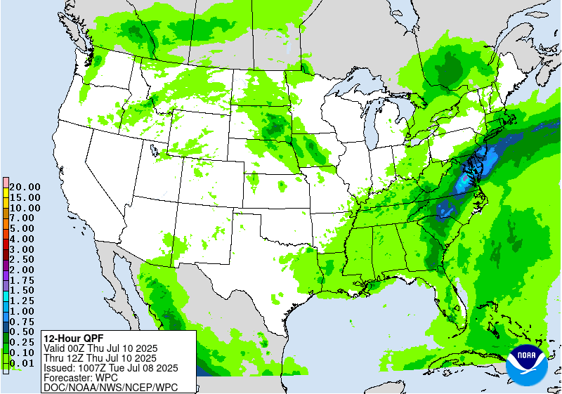
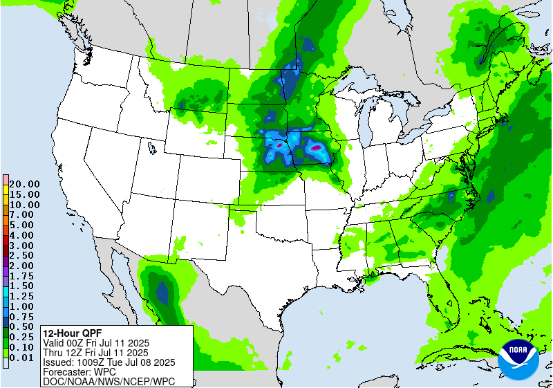
...Tennessee Valley into the Mid-Atlantic and New England...
A warm and anomalously moist air mass looks to remain in place
across much of the Southeast and Eastern U.S. into Thursday
continuing a broad flash flood threat into yet another day.
Although upper-level forcing looks less impressive overall relative
to Wednesday, still expect another round of primarily diurnally
driven convection focused along the terrain and associated leeward
trough of the Appalachians, perhaps becoming best organized a bit
farther south than prior days as the combination of best forcing
and moisture/instability looks concentrated across the southern
Mid-Atlantic into portions of the Southeast. Maintained an
inherited SLGT risk area for more vulnerable portions of central NC
and surrounding far south-central VA, but this area will likely be
modified over subsequent forecast cycles with dependencies on both
trends in the guidance and how the forecast ultimately pans out for
days 1 and 2 (as antecedent conditions will be a big factor). The
latest trends in the guidance suggest the threat will be more muted
from much of VA northward (with subtle height rises aloft from
sub- tropical ridging tries to offset the more favorable parameter
space for heavy rainfall).
...Northern and Central Plains into the Upper Midwest...
By Thursday the persistent ridge aloft over the Southwest U.S.
begins to break down, as an upper-low off the northern CA coast
opens up into a shortwave trough on Wednesday and ejects eastward
ahead of a digging longwave trough over western Canada. These two
features look to interact over the Northern and Central Plains, but
there are still substantial differences between models in how these
features evolve and interact. Maintained an inherited SLGT risk
area in the vicinity of where the best QPF signal overlaps (west-
central IA into adjacent portions of NE/SD/MN), but this area is
likely to shift over the coming days as models find a better
consensus of where organized convection is most likely to occur.
Regardless of where exactly this occurs, PWs of 1.5"+ are expected
(near or above 90th percentile for the region) with ample
instability and dynamics for organized convection and subsequent
high rainfall rates.
Churchill
Day 3 threat area:
www.wpc.ncep.noaa.gov/qpf/99epoints.txt


