Excessive Rainfall Discussion
NWS Weather Prediction Center College Park MD
856 PM EDT Tue Jul 8 2025
Day 1
Valid 01Z Wed Jul 09 2025 - 12Z Wed Jul 09 2025
...THERE IS A SLIGHT RISK OF EXCESSIVE RAINFALL FOR A PORTION OF
THE MID ATLANTIC STATES AND FOR PARTS OF THE SOUTHERN PLAINS AND
SOUTHERN MISSISSIPPI VALLEY OVERNIGHT...
...01Z Excessive Rainfall Discussion Update...
Given progressive nature of a front making its way across the
northeast quarter of the country...was able to remove the Slight
Risk area from most of the region away from the the coastal
portions of the Mid Atlantic. Maintained a Marginal Risk extending
over parts of southern Virginia and adjacent portions along the
border in North Carolina where enough instability lingered ahead
of the front and where guidance maintained signals for convection
overnight.
Maintained the Slight Risk area over portions of
Oklahoma...Texas...Arkansas...Louisiana where convection was
persisting in a region of CAPE on the order of 1500 to 2500 J per
kg was roughly collocated within a band of precipitable water
values from 2 to 2.25 inches. With 1.5 to 2.5 inch per hour
rainfall rates from slow moving cells...isolated rainfall totals in
excess of 3 inches in less than 3 hours are possible. These rates
begin to challenge the 3 to 4 inch per 3 hour flash flood guidance
values.
Felt it was a little too soon to remove the Marginal from
southeast New Mexico where the RAP was maintaining 1000 to 1500 J
per kg into the late evening.
Bann
Previous Excessive Rainfall Discussion...
...Mid-Atlantic and Northeast...
16Z Update: The overall synoptic and mesoscale scheme are still
relevant from previous forecast, although one note to point out is
the increasing potential for more locally enhanced flash flood
concerns focused across portions of Southeast VA. 12z CAMs are much
more bullish on the area between I-95 to the mouth of the Potomac
in VA for the highest precip output in the period. A lot of the
setup is driven by the training prospects in the vicinity of
Richmond through Williamsburg up to the areas running adjacent to
the Rappahannock River. 12z HREF neighborhood probs are running
between 40-60% for >3", but between 60-80% for >2" leading to a
strengthening signal compared to previous forecast output as noted
in the previous discussion below. This aligns with the increased
low-level convergence pattern as the mean layer wind becomes
generally unidirectional after 00z across Central and Southeast VA
with the approach of a shortwave expected to eject out of
Southwest VA. With coordination from the local Wakefield, VA WFO,
have expanded the SLGT risk into all of Southeast VA to account for
the threat.
Further north into the Megalopolis of the Mid Atlantic and
Northeast, the best threat for heavy rainfall will likely be
situated over Southern New England down into NYC where a secondary
focus will occur as a shortwave analyzed over Western PA lifts to
the east-northeast and centers over the above zone by later this
evening. Environment remains favorable for locally stronger
convective cores to produce rainfall rates in excess of 1"/hr,
especially with the assessment of 12z KOKX PWATs coming in ~2", a
reading encroaching the 30-day moving max, and eclipsing the daily
max for the 8th. The high urbanization factor always constitutes
close monitoring for locally impactful flash flooding, so the
threat remains well within the threshold for a SLGT risk leading to
general continuity for the forecast.
Kleebauer
..Previous Discussion..
The remnants of post-tropical cyclone Chantal are in the process of
transitioning into an open trough while exiting east of Cape Cod
to start the period, as it continues to get caught up in increasing
southwesterlies downstream of a trough approaching from the Great
Lakes. This trough will continue to translate eastward through the
day, but will be slow to advect due to downstream Bermuda-type
ridging. Between these two features, southwest flow will remain
prevalent over the area, with 850-500mb winds being nearly
unidirectional from the W/SW at 15-20 kts. This will result in a
continued extremely moist environment with PWs likely eclipsing 2"
from eastern VA through southern New England Tuesday afternoon,
coincident with a plume of SBCAPE exceeding 2000 J/kg (per 00z HREF
mean fields).
Into these impressive thermodynamics, a subtle shortwave embedded
within the mean flow will traverse northeast ahead of a cold front
and along a surface trough, providing additional ascent atop the
already impressive convergence on these boundaries. The 00z hi-res
CAM consensus suggests showers and thunderstorms will become
numerous to widespread along and near the front during the mid to
late afternoon, and storm motions are expected to initially be
quite slow (0-1 km mean flow near 10 kts) with the potential for
localized backbuilding and training along the surface trough and
front (as Corfidi vectors collapse to around 5 kts with the
development of deep convection and resulting outflow boundaries).
With warm cloud depths potentially eclipsing 14,000 ft, this will
support efficient warm-rain processes and rain rates above 2"/hr
at times (and resulting localized hourly totals of 1-2"). Where
training occurs, this could result in total rainfall in excess of
3" (per 00z HREF 40-km neighborhood 3" exceedance probabilities
ranging from 10-40% across the SLGT risk area). Scattered
instances of flash flooding are possible across much of the I-95
corridor from Richmond, VA to Boston, MA.
Churchill
...Southern Plains through the Ohio Valley...
16Z Update: A targeted area across Eastern OK into Western AR now
exists as a higher-end SLGT with some locally significant impacts
plausible over the aforementioned area. Current WV satellite and UA
analysis depicts a prevalent mid-level shortwave located within the
confines of Northeast OK and Southeast KS dipping southeast over
the last several hrs. Enhanced sfc-500mb convergence pattern over
Eastern OK to the AR/OK line is already materializing with a
solidified low-level inflow pattern advecting unstable air into the
vicinity of the mid-level circulation. Latest RAP surface analysis
pins a target of 1000-2000 J/kg of SBCAPE located over the axis of
greatest convergence with PWATs noted to be ~2" as 12z KLZK
sounding just to the east depicted a PWAT observation of 1.99",
above the 90th percentile daily output. The combination of a
pronounced area of buoyancy and focused surface convergence on the
southern flank of the shortwave will create an opportunity for
locally enhanced hourly rates between 2-3+"/hr through the next 3-6
hrs before the threat wanes with the progression of the shortwave
migrating eastward. For more information on this threat, please see
MPD #0619 for the latest.
More convection will fire this evening across Southern MO with the
strongest cells likely to induce some 2-3"/hr rates for a short
time, enough to warrant some attention for flash flood prospects
across the Ozarks due to the local topography. The SLGT risk was
expanded to include those areas where 12z CAMs have highlighted the
potential.
No additional changes were made across the Midwest and Mid-
Mississippi Valley, but will monitor the progression and expected
output from the MCV as it migrates into IL this afternoon and
evening. Some spots may see 2-4" of rainfall which could very well
induce flash flooding, especially in any urbanized areas where run
off prospects are highest, generally in-of and between St. Louis to
Springfield, IL.
Kleebauer
..Previous Discussion..
Farther north near the base of the trough (into MO/IL), an MCV has
the potential to locally organize convection with better overall
dynamics (DPVA and shear from right-entrance region of jet streak)
compared to farther south (despite overall tropospheric moisture
likely to remain a bit lower with PWs less than 2.0" (but still at
or above 90th percentile). CAMs are not as aggressive with this
area, but will need to be monitored closely today given the MCV
and added daytime instability (HREF indicating SBCAPE rising to
1500-2500 J/kg).
Churchill
...Upper Midwest...
16Z Update: No changes to the previous forecast as the general
synoptic and mesoscale pattern remains on track with little run to
run deviation.
Kleebauer
..Previous Discussion..
A wave of low pressure and accompanying surface trough will move
progressively eastward from Minnesota into Michigan the first half
of today. While this will be generally fast moving, it will
impinge into a favorable environment to support heavy rain rates
which will likely eclipse 1"/hr, especially where it overlaps a
ribbon of MUCAPE reaching 1000-2000 J/kg. The fast motion will
limit total rainfall, but in some places that receive multiple
rounds of heavy rain, event totals could reach 2-3". This falling
atop sensitive soils (FFG as low as 1-1.5"/3hrs) could produce
localized instances of flash flooding.
Churchill
......Southeastern New Mexico...
16Z Update: The pattern remains favorable for another diurnally
driven convective pattern in-of the terrain of NM, especially in
the confines of the Sacramento Mtns. up to the Sandia's to the east
of ABQ. No changes were necessary from the previous forecast MRGL
risk issuance.
Kleebauer
..Previous Discussion..
Another daily round of showers and thunderstorms is
expected to develop in the high terrain and then drop southeast
into the High Plains and southeastern portions of New Mexico.
Although storms are expected to be generally progressive as they
come off the terrain (0-6km mean winds from the north around 15
kts), they will move into an axis of more favorable thermodynamics
characterized by PWs of above 1" and MUCAPE approaching 1000 J/kg.
This could support briefly heavy rain rates above 1"/hr, supporting
an isolated risk for flash flood impacts across urban areas or
sensitive terrain and burn scars.
Churchill/Weiss
Day 1 threat area:
www.wpc.ncep.noaa.gov/qpf/94epoints.txt
Excessive Rainfall Discussion
NWS Weather Prediction Center College Park MD
530 AM EDT Wed Jul 9 2025
Day 1
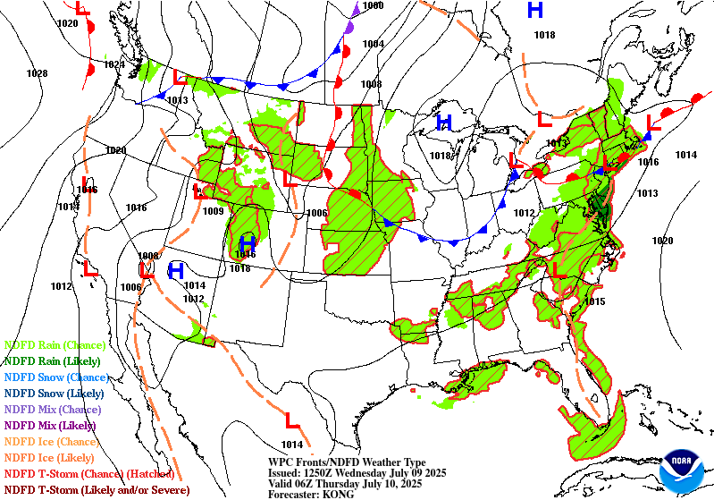
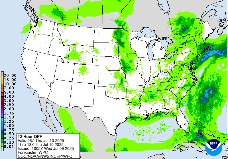
Valid 12Z Wed Jul 09 2025 - 12Z Thu Jul 10 2025
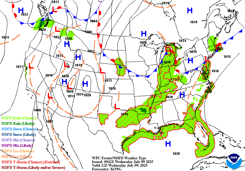
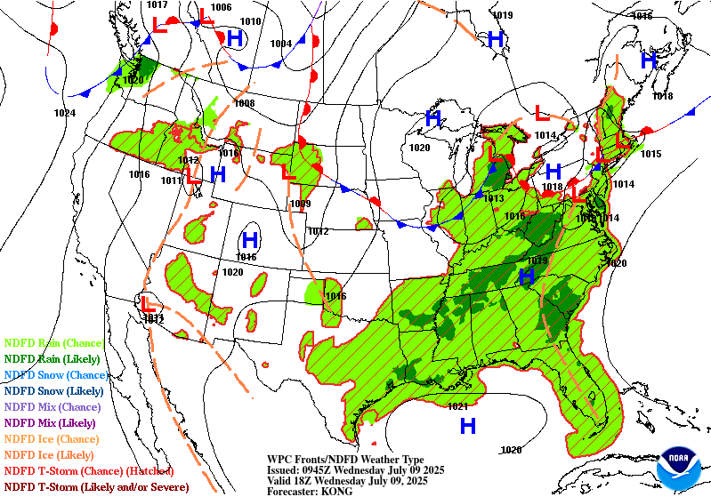
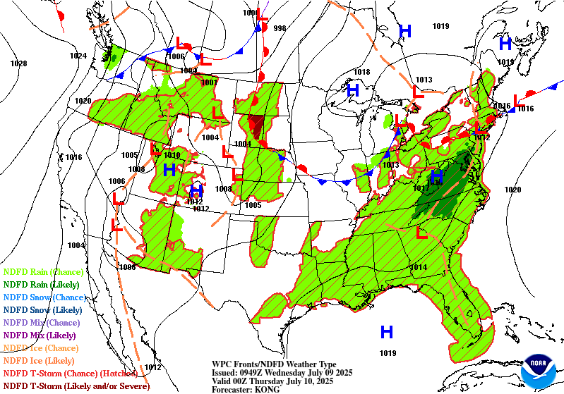
...THERE IS A MODERATE RISK OF EXCESSIVE RAINFALL FOR PORTIONS OF
THE MID ATLANTIC...
...Mid-Atlantic and Southeast...
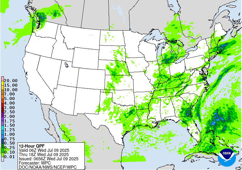
An anomalously moist and conditionally unstable air mass remains
entrenched across much of the eastern third of the CONUS, as a
pronounced mid-level trough extending from the Great Lakes to the
Mid-South gradually translates eastward. Height falls and DPVA from
this trough (along with increasing 0-6km bulk shear and enhanced
upper divergence from the favorable placement of a right-entrance
region of ~100 kt jet streak over New England) will coincide with
peak daytime heating and steep low-level lapse rates, eventually
resulting in widespread convective activity this afternoon across
much of the Mid-Atlantic (focused within the terrain and along the
leeward trough of the Appalachians) and into the Southeast (where a
TUTT cell is also playing a role, as some convection is already
ongoing early this morning in portions of southern GA and northern
FL). While much of the Southeast has been rather dry over the past
3-7 days, some portions of the Mid-Atlantic remain quite saturated
from prior days rainfall (and particularly from heavy rainfall in
association with Tropical Storm Chantal, which resulted in an area
of 4-10" of rainfall across central NC into south-central VA). A
Moderate risk was introduced with this forecast cycle for a
targeted portion VA (where flash flood warnings are even still in
effect at the time of writing from continuing convection
overnight), and this area represents the best overlap of
anticipated convective organization coinciding with vulnerable
antecedent conditions (as storms may be less organized farther
south where the bulk of rainfall occurred with Chantal, and
residence time may be too short farther north where stronger
dynamics will support the forward propagation of convection).
While the new Moderate risk area represents where more numerous
flash flood impacts are most likely to occur (with 00z HREF
neighborhood probabilities for FFG exceedance as high as 40-50%),
the Slight risk area has also been expanded fairly significantly to
encompass a large area from the Southeast (eastern GA into central
SC) into nearly all of the Mid-Atlantic (including the bulk of the
southern and central Appalachians) as PWs of 2.0"+ (near or above
the 90th percentile for much of the region) will allow for highly
efficient rainfall rates (with wet-bulb zero heights of 13-14k feet
allow warm rain processes to dominate) with localized totals of
1-3"/hr. Where these types of rates train/repeat, localized totals
of 2-5" are likely to occur (with the highest coverage of these
totals expected in and around the Moderate risk area). The threat
looks to be concentrated with peak daytime heating, mainly from
21-03z this afternoon and evening.
...Central Texas through the Southern Ohio Valley...
As the aforementioned mid-level trough crosses the OH Valley this
morning, a convective risk will be maintained for much of the day
from the Mid-South through the TN/OH Valley with elevated moisture
and increasing low-level lapse rates and instability from daytime
heating. Farther southwest into the Ark-La-Tex and central TX,
vorticity streamers from the trough are being shunted southwestward
(gradually rounding the persistent upper ridge over the Southwest)
and may help to locally organize convective activity. Elevated PWs
(generally between the 75th and 90th percentile) along with strong
daytime heating will result in generally scattered convection with
still efficient rainfall rates (up to 1-3"/hr) but limited coverage
and residence time resulting in isolated/localized totals of 2-4".
The Marginal risk was maintained and adjusted based on the new
guidance in this region.
...Central Plains into Mid-Mississippi Valley...
A shortwave rotating along the northern periphery of a ridge
centered over the Southwest U.S. will eject out of the northern
extent of the Front Range later today, leading to more focused
ascent and convective initiation portions of KS/NE into IA/MO by
later this afternoon/evening. While overall tropospheric moisture
and resulting rainfall rates are less impressive in this area,
there is some potential for upscale growth and convective
organization given increasing 0-6km bulk shear and steepening mid-
level lapse rates. While there is still considerable uncertainty
and hi-res model spread with the evolution and placement of higher
totals, HREF neighborhood probs suggest low-end chances (10-15%)
for localized 3" exceedance. This may bring a threat of isolated
flash flooding (which could go well into the overnight hours), and
the inherited Marginal risk area was adjusted accordingly based on
the new guidance.
Churchill
Day 1 threat area:
www.wpc.ncep.noaa.gov/qpf/94epoints.txt
Excessive Rainfall Discussion
NWS Weather Prediction Center College Park MD
530 AM EDT Wed Jul 9 2025
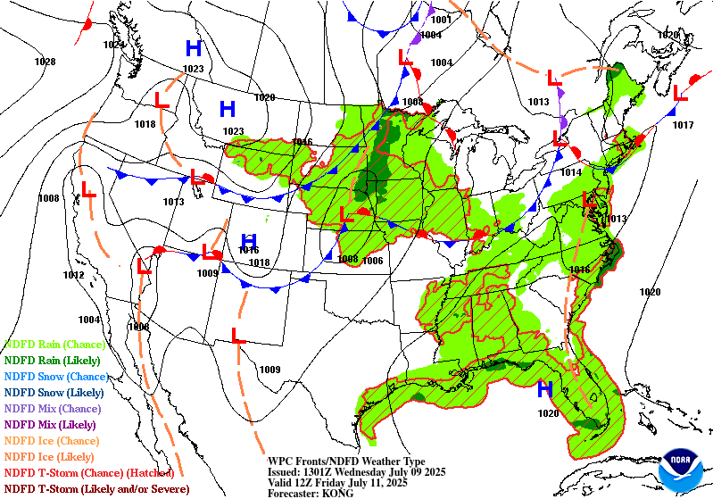
Day 2
Valid 12Z Thu Jul 10 2025 - 12Z Fri Jul 11 2025
...THERE IS A SLIGHT RISK OF EXCESSIVE RAINFALL FOR PORTIONS OF THE
MID ATLANTIC...
...Tennessee Valley into the Mid-Atlantic and New England...
A warm and anomalously moist air mass looks to remain in place
across much of the Southeast and Eastern U.S. into Thursday
continuing a broad flash flood threat into yet another day.
Although upper-level forcing looks much less impressive overall
relative to Wednesday, still expect another round of primarily
diurnally driven convection focused along the terrain and
associated leeward trough of the Appalachians. Maintained an
inherited Slight risk area for more vulnerable portions of NC and
VA (from the Piedmont into the Coastal Plain) where the consensus
ensemble guidance signal remains highest for convective
organization (as vorticity streamers from the mid-level trough on
Wednesday may trail behind in the southern Appalachians long enough
to favorably support convective organization with peak daytime
heating on Thursday).
...Northern and Central Plains into the Upper Midwest...
By Thursday the persistent ridge aloft over the Southwest U.S.
begins to break down, as an upper-low off the northern CA coast
opens up into a shortwave trough on Wednesday and ejects eastward
ahead of a digging longwave trough over western Canada. These two
features look to interact over the Northern and Central Plains, but
there are still substantial differences between models in how
these features evolve and interact. PWs of 1.5"+ are expected
(near the 90th percentile for the region) with ample instability
and dynamics for organized convection and subsequent high rainfall
rates (as this shortwave trough looks much more potent relative to
the expected shortwave on Day 1). Maintained an inherited Slight
risk area that was adjusted based on the new consensus guidance.
Churchill
Day 2 threat area:
www.wpc.ncep.noaa.gov/qpf/98epoints.txt
Excessive Rainfall Discussion
NWS Weather Prediction Center College Park MD
530 AM EDT Wed Jul 9 2025
Day 3
Valid 12Z Fri Jul 11 2025 - 12Z Sat Jul 12 2025
...THERE IS A MARGINAL RISK OF EXCESSIVE RAINFALL FOR PORTIONS OF
THE MID-ATLANTIC INTO THE SOUTHEAST, THE MID-MISSISSIPPI VALLEY
INTO THE MIDWEST, AND MUCH OF THE ROCKIES INTO THE CENTRAL AND
SOUTHERN HIGH PLAINS...
...Mid-Atlantic and Southeast...
As mid-level troughing becomes more established in the Northern
Plains into Day 3, ridging builds in response downstream and may
finally begin to suppress convection more significantly across the
northern Mid-Atlantic into the Northeast. While there are no clear
signs of significant convective organization at this juncture into
the Southeast and southern Mid-Atlantic, convective initiation with
scattered convection and locally high rainfall rates appears likely
(where ridging will be insufficient to fully suppress convection).
...Mid-Mississippi Valley into the Midwest...
More substantial convective organization is possible downstream of
shortwave troughs progressing/interacting in the Northern Plains
(placing the best risk more firmly into the Mid-MS Valley and Upper
Midwest). While the global ensemble guidance is coming into better
agreement with the QPF maxima, confidence is too low to introduce
a Slight risk with this cycle (with consensus guidance suggesting
1-3" totals, though so solutions suggest localized totals of up to
3-6" with inconsistent placement of the axis). Will continue to
evaluate with future cycles for the potential for an upgrade to
Slight risk.
...Rockies into the Central and Southern High Plains...
As the Southwest ridge continues to break down for a second day,
the global guidance signal for more substantial convective
initiation within the terrain of the Rockies increases into Friday
(and particularly so farther north into the northern/central
Rockies of WY/CO). Localized 1-2" totals (as indicated by both
downscaled deterministic GFS/ECMWF solutions and ensemble 1"
exceedance probabilities) in the sensitive terrain may lead to
localized flash flooding concerns, and more substantial convective
organization in association with shortwaves/vorticity maxima
rounding the ridge and coming off the terrain may allow for more
organized convection into the evening/overnight in the Central and
Southern High Plains.
Churchill
Day 3 threat area:
www.wpc.ncep.noaa.gov/qpf/99epoints.txt
Extended Forecast Discussion
NWS Weather Prediction Center College Park MD
228 AM EDT Wed Jul 9 2025
Scattered convection anticipated to fire ahead of, and along
progressive
cold fronts, stalled boundaries and round the upper high in the
Southern Rockies. The exact location of anticipated higher QPF
amounts remain a bit uncertain given persistent model differences,
nevertheless, there is potential for isolated instances of
excessive rainfall and localized flash flooding.
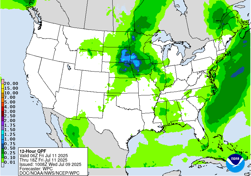
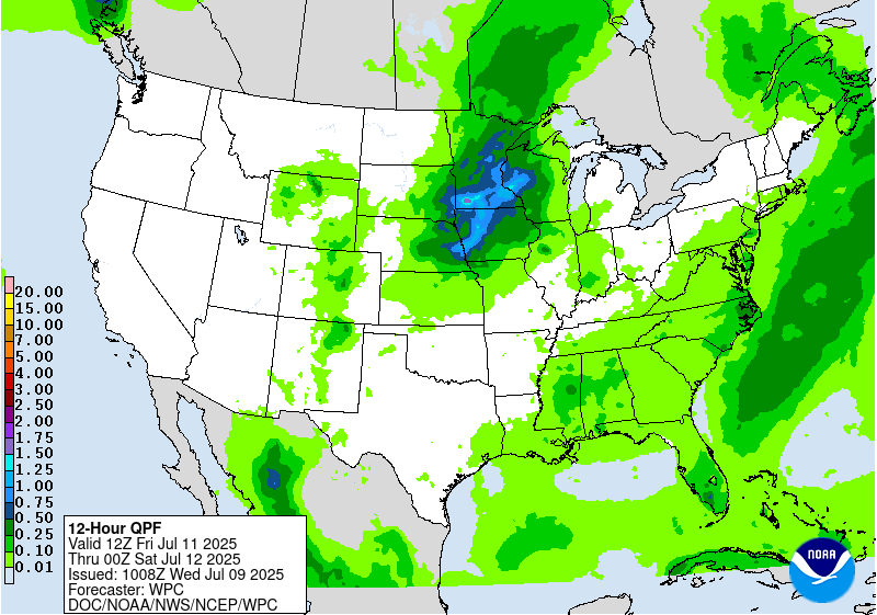
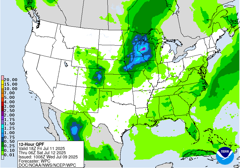
For Day 4, there is a Slight Risk for excessive rain for portions
of Kansas and Oklahoma where a MCS will likely setup and an
enveloping broad Marginal Risk enveloping from the Southern Plains
east to Pennsylvania and north to the Minnesota arrowhead. Another
Day 4 Marginal Risk area is in effect for eastern New Mexico into
the Texas Panhandle. The potential for heavy rainfall near the
front boundary over the central U.S. will persist therefore a
Marginal Risk was raised for Day 5 for portions of the Southern
Plains, Midwest into the Ohio Valley. Convection along the eastern
coast of Florida may lead to isolated flash flooding/ponding in
urban areas so a small Marginal Risk area was raised for Day 5 as
well. Although there is fair amount of spread in QPF placement, a
couple model solutions are hinting at a concentration of QPF near
parts of eastern New Mexico/West Texas and for southern parts of
the Hill Country. Confidence is low at this time but worth noting
that this area will continue to be monitored given the extreme
sensitivity with ongoing flooding.
Numerous locations will have daily reading above 100, with several
nearing the 110s in the lower elevations. Conditions will mainly be
dry across the West/Southwest, except for perhaps far southeastern
Arizona into New Mexico where some monsoonal moisture may be
present.
Campbell
Extended Forecast Discussion
NWS Weather Prediction Center College Park MD
228 AM EDT Wed Jul 9 2025
Scattered convection anticipated to fire ahead of, and along
progressive
cold fronts, stalled boundaries and round the upper high in the
Southern Rockies. The exact location of anticipated higher QPF
amounts remain a bit uncertain given persistent model differences,
nevertheless, there is potential for isolated instances of
excessive rainfall and localized flash flooding.
For Day 4, there is a Slight Risk for excessive rain for portions
of Kansas and Oklahoma where a MCS will likely setup and an
enveloping broad Marginal Risk enveloping from the Southern Plains
east to Pennsylvania and north to the Minnesota arrowhead. Another
Day 4 Marginal Risk area is in effect for eastern New Mexico into
the Texas Panhandle. The potential for heavy rainfall near the
front boundary over the central U.S. will persist therefore a
Marginal Risk was raised for Day 5 for portions of the Southern
Plains, Midwest into the Ohio Valley. Convection along the eastern
coast of Florida may lead to isolated flash flooding/ponding in
urban areas so a small Marginal Risk area was raised for Day 5 as
well. Although there is fair amount of spread in QPF placement, a
couple model solutions are hinting at a concentration of QPF near
parts of eastern New Mexico/West Texas and for southern parts of
the Hill Country. Confidence is low at this time but worth noting
that this area will continue to be monitored given the extreme
sensitivity with ongoing flooding.
Numerous locations will have daily reading above 100, with several
nearing the 110s in the lower elevations. Conditions will mainly be
dry across the West/Southwest, except for perhaps far southeastern
Arizona into New Mexico where some monsoonal moisture may be
present.
Campbell


