January 01*
January 02*
January 03*
January 04*
January 16*
January 17*
January 18*
January 19*
January 20*
January 23*
January 24*
January 25*
January 26*
January 30*
January 31*
February 01*
February 02*
February 13*
February 14*
February 15*
February 16*
February 20*
February 21*
February 22*
February 23*
February 24*
February 25*
February 26*
February 27
February 28
March 01
March 03
March 04
March 10
March 11*
March 12*
March 13*
March 14*
March 15*
March 21
March 27*
March 28*
March 29*
March 30*
March 31*
April 01*
April 03
April 04
October 24*
October 25*
October 26*
October 27*
December 02
December 25
December 26
January 01*
January 02*
January 03*
January 04*
January 05
January 06*
January 07*
January 08
January 14*
January 15*
January 16*
January 17*
January 18*
January 20*
January 21*
January 22*
January 28*
January 29*
January 30*
January 31
February 01*
February 02*
February 03*
February 04*
February 16*
February 17*
February 18*
March 08*
March 09*
March 10*
March 11*
March 12*
April 11*
April 12*
April 13*
April 14*
April 22*
April 23*
April 24*
November 07*
November 08*
November 09*
November 10*
November 11*
December 09*
December 10*
December 11*
December 12*
December 13*
December 14*
December 15*
December 16*
December 17*
December 20*
December 21*
December 22*
December 23*
December 24*
December 25*
December 26*
December 31*
January 01*
January 09*
January 10*
January 11*
January 14
January 25*
January 26*
January 27*
January 28*
January 29*
January 30*
January 31*
February 01*
February 02*
February 06
February 07
February 12*
February 13*
February 14*
February 15*
February 16*
February 17*
February 18*
March 13*
March 14*
March 15*
October 11*
October 12*
October 13*
December 09*
December 10*
December 11*
December 12*
December 13*
December 14*
December 15*
December 23*
December 24*
December 25*
December 26*
December 27*
December 30*
December 31*
January 01
January 07
January 11
January 12
January 13
January 14
January 18
January 19
February 04
February 05
February 06
February 07
February 08
February 09
February 10
February 11
February 12
February 27
March 14
March 15
April 12*
April 13*
May 09
October 23*
October 24*
October 25*
October 26*
October 27*
October 28*
November 07*
November 08*
November 09*
November 14
December 16*
December 17*
December 23*
December 24*
December 25*
December 28*
December 29*
December 30*
December 31*
January 01
January 12*
January 13*
January 14*
January 17*
January 18*
January 19*
January 20*
January 21
January 23
January 28*
January 29*
January 30*
February 04
February 05
February 06*
February 07*
February 08*
February 10
February 12
February 13
February 14
February 15
February 17
February 20
February 21
February 22*
February 23*
February 24*
February 25*
February 26
February 27
March 03
March 04
March 09*
March 13*
March 14*
April 10*
April 11*
April 12*
September 29
September 30
October 09*
October 10*
October 11*
November 11
November 12
November 26*
November 27*
November 28*
November 30*
December 01*
December 02*
December 03*
December 16
December 18
December 28*
December 29*
December 30*
December 31
January 04
January 05
January 12
January 13
January 17
January 18
January 21
January 22
January 23
February 08
March 02
March 03
March 06
March 08
March 09
March 14
March 22
March 25
March 31
April 04
April 14
April 15
April 16
November 15
November 16
November 24*
November 25*
November 26*
December 01
December 02
December 08*
December 09*
December 10*
December 26*
December 27*
December 28*
January 03
January 06
January 22
January 29
January 30
February 04
February 05
February 06
February 08
February 09
February 13
February 14
February 16
March 01
March 02
March 03
March 04
March 07
March 13
April 01
April 04
April 17
May 12
November 03
November 11
November 12
November 15
November 27
December 11
Menu is populated with significant winter weather events as they occur.
*Indicates WPC has written an event review for this date.
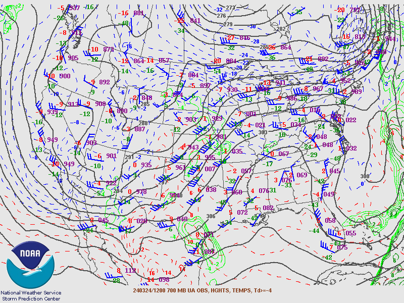
| March 24 2024 |


