| December 29 2020 |
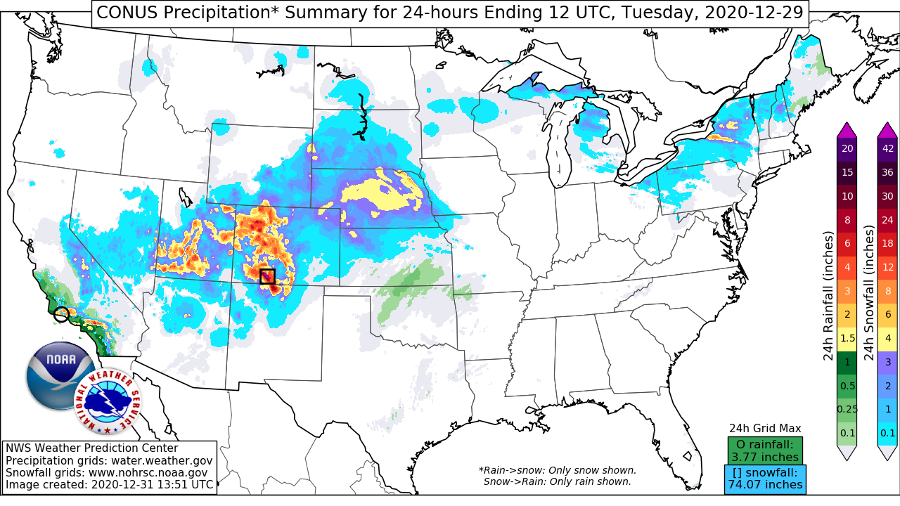
Southern California to Midwest Winter Storm: (12/28 - 12/29)
By: Frank Pereira, WPC Meteorologist
Meteorological Overview:
From Monday, 28 December to Tuesday, 29 December 2020, a fast-moving winter storm impacted a significant portion of the western and central United States. In addition to heavy snow that blanketed the mountains from Southern California to the central Rockies, the storm was also notable for a band of heavy snow that developed over the Midwest - establishing new daily snowfall records for some cities.
Heavy snow began early 28 December in the mountains of Southern California and continued through the day as a closed upper low developed offshore and moved across California. Strong westerly winds south of the low center directed ample moisture onshore, supporting the development of heavy precipitation across Southern California. As heavy rain fell along the coastal areas, snow levels dropped to around 3500 feet, with heavy snow accumulations reported in the coastal mountain ranges east of Los Angeles. Meanwhile, as the upper system began to move east across California into Nevada, southwesterly flow intensified across the southwestern United States, drawing deeper moisture into areas that included Utah, Colorado, and northern New Mexico. This increasing moisture, along with the large-scale ascent afforded by the left-exit region dynamics of an intensifying upper jet, helped to support the development of heavy snow from the mountains of southern and central Utah to western Colorado and northern New Mexico. Orographically enhanced snowfall accumulations were noted across the region, including the San Juan Mountains in southwestern Colorado and far northern New Mexico - a mountain range known for its heavy snowfall accumulations during southwesterly wind events.
As the upper low continued to move east across the Great Basin, deepening moisture and increasing ascent east of the mountains supported the development of precipitation over the central High Plains during the afternoon hours of 28 December. Beginning during the evening and continuing into early 29 December, a coupled upper jet along with increasing mid-level frontogenesis helped to support an expanding area of precipitation, including pockets of moderate to heavy snow spreading north from eastern Colorado and Kansas into Nebraska. The upper low began to weaken during this time - ejecting out to the northeast as it interacted with an upper trough dropping south through central Canada toward the northern Great Plains. This helped to spread precipitation farther to the north and east across the Dakotas into Minnesota during the mid to late morning hours. However, the upper pattern remained highly amplified over the western United States, with the leading edge of a deep upper trough shifting east across the Rocking into the Great Plains - setting the stage for redeveloping precipitation farther to the south. By early afternoon, radar and surface observations indicated a band of organized moderate to heavy precipitation developing from southeastern Nebraska into southern Iowa. Mesoanalysis fields showed this band developed near an area of 50-70 knot 850mb southerly winds, drawing moisture into a region of strong 850 hPa frontogenesis. This along with favorable upper jet forcing helped maintain this band as it moved slowly northeast through the late afternoon hours - reaching northern Illinois and southern Wisconsin by early evening. During the overnight hours, the band began to weaken as it reached farther east into Lower Michigan.
Impacts:
On Monday, heavy snowfall was reported along the coastal mountain ranges of Southern California, with some high elevation areas receiving over a foot of snow. Numerous traffic incidents occurred in the mountains east of Los Angeles, with motorists reporting being stuck for hours on Interstate-15 near the Cajon Pass. The storm continued to impact areas farther east on Monday, with multiple accidents reported across southern Utah, including along Interstate-15. Heavy snowfall spread across the central Rockies late Monday into Tuesday, with portions of the San Juan Mountains receiving well over two feet of snow. A vehicle incident involving an Amazon truck on Interstate-70 at Vail Pass, Colorado damaged the highway, resulting in the highway’s closure a day later to recover the truck and to make the necessary road repairs. As snow spread east of the mountains and into the central Great Plains Tuesday morning, Interstate-80 in western Nebraska was closed for several hours in both directions following several accidents. By mid-morning, Omaha police reported several accidents due to hazardous road conditions. By 10 a.m., the Des Moines Police Department had begun responding to what would total more than 230 traffic-related incidents due to the weather throughout the day.
That day, the Iowa State Patrol reported responding to nearly 100 weather-related vehicle crashes across the state. Many locations from southeastern Nebraska to southern Wisconsin reported snow amounts of 6 inches or more, with up to a foot reported near Cedar Rapids, Iowa. Both Omaha, which reported 6.8 inches of snow, and Des Moines, which recorded 9.6 inches, set daily snowfall records for 29 December. South of the heavier snow, a wintry mix consisting of snow, sleet, and freezing rain fell across Kansas, northern Missouri, far southern Iowa, and central Illinois. There were widespread reports of accumulating ice across the region, with some locations reporting ice accumulations of 0.25 inch or more.


