


| January 13 2024 |
Central Rockies to Great Lakes Winter Storm: (1/11/24 - 1/14/24)
By: Peter Mullinax, WPC Meteorologist
Meteorological Overview:
During the day of January 10, a 998mb area of low pressure over southeast Washington was being escorted south and east towards the central Rockies by a potent 500mb trough over the Pacific Northwest. As the 500mb trough amplified on approach, the divergent left-exit region of a 125kt 250mb jet streak supplied ample upward vertical motion in the upper levels of the atmosphere while modest Pacific moisture also streamed through the Northwest and into the Rockies. This resulted in heavy mountain snow over the Cascades south into the northern Rockies late on January 9. By January 10, heavy snowfall spread south to the Sierra Nevada, across the Great Basin, over the Tetons and Wasatch, and eventually into the Colorado and southern Wyoming Rockies. By the morning of January 11, the mean 250-500mb trough had strengthened over the Intermountain West, fostering increased upper level ascent over the central Great Plains and led to the birth of an 850mb low over northeast Colorado. As southerly 850mb winds and 850-700mb warm air advection increased throughout the day and an Arctic front dove south through the Midwest, a strengthening frontal wave allowed for the 850mb low to deepen, culminating in a surface low of 995mb northwest of Oklahoma City by 00Z January 12. To the north of the front, snow enveloped central to eastern Nebraska Thursday evening and then into southern Iowa and northern Illinois Thursday night.
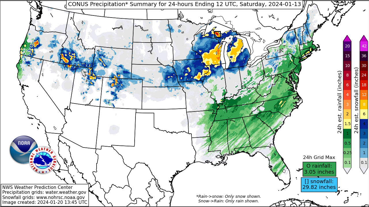
By the morning of January 12, heavy snow fell from the Missouri River to the western Great Lakes. The 12Z surface analysis showed a 993mb low over southern Missouri with a stationary front oriented SE to NW from eastern Kansas to northern Wisconsin. It is on the western flank of this front that was effectively the “rain-snow” line at the start of this event. However, as a pair of 500mb troughs were taking on negative tilts and the divergent left-exit region of a 150kt 250mb jet streak positioned itself over the Great Lakes, the surface low would deepen from 995mb at 00Z January 12 to 981mb over the Chicago metropolitan area 24 hours later (00Z January 13). By 00Z January 13, heavy snow was occurring beneath the deformation axis located on the northwest flank of the 850mb low, which was positioned from the nose of Iowa to south-central Wisconsin. As the primary low began to occlude by 03Z January 13, heavy snow fell beneath the TROWAL over central Wisconsin and to the north of the occluded front over northern Michigan. Snowfall totals were limited along the coastline of southern Wisconsin and northern Illinois due to milder lake water temperatures of Lake Michigan allowing for a later changeover to snow.
By the early morning hours of January 13, the deformation axis was shifting from Michigan’s Upper Peninsula into Ontario as a 981mb low tracked over Lake Huron. However, the onslaught of heavy snow continued in the Upper Peninsula and western shores of Michigan as cold air advection over Lakes Superior and Michigan sparked numerous heavy lake effect snow showers. By 18Z, as the 981mb low tracked towards southern Quebec, the same cold air advection aloft would trigger lake effect snow bands downwind of Lakes Erie and Ontario later that day and into Saturday night. Sufficiently cold temperatures and persistent cyclonic flow over the Great Lakes would keep lake effect snow bands lingering into the day on Sunday, January 15 with very heavy snowfall rates occurring north of Buffalo, NY and over the Adirondacks of far northern New York.
Impacts:
The heaviest snowfall totals occurred in Michigan and New York where prolonged lake effect snow bands led to amounts topping 30 inches in some areas. According to WPC’s last Storm Summary for the event, Derby, NY (located southwest of Buffalo) reported an impressive 41 inches with some of Buffalo’s southern suburbs reporting over 30 inches. In Michigan, the towns of Herman and Champion (located west of Marquette in the Michigan U.P.) measured over 30 inches. In the Midwest, areas that were ideally placed beneath the storm’s deformation zone saw well over a foot of snow. In fact, a handful of locations in central and eastern Iowa, northern Illinois, and south-central Wisconsin reported as much as 20 inches. In terms of records, according to NWS Quad Cities WFO, Moline, IL reported its fourth-highest event snowfall on record (records date back to 1884). January 12, 2024 was also the second snowiest single day (15.4 inches) in Moline, IL’s recorded history with only January 3, 1971 holding the single snowiest day record (16.4 inches).
In terms of impacts, the snow and bitter cold that followed would significantly affect presidential candidates campaigning ahead of the Iowa Caucuses on Monday, January 15. Events were canceled or had to be done virtually due to travel being so poor and some businesses having to close. As far west as the Sierra Nevada, the heavy snow and gusty winds fostered hazardous conditions for avalanches. This unfortunately occurred on January 10 when an avalanche was responsible for three injuries and one fatality at the Palisades Tahoe resort. In Kansas, portions of Interstate 70 had to be closed due to whiteout conditions, black ice, and numerous crashes. The storm produced an exceptional swath of high winds as well, causing as many as 375,000 power outages from the Great Lakes to as far east as the Mid-Atlantic on January 13. The strong surge of southerly wind out ahead of the storm even caused coastal flooding along the shores of New England on January 13 as well. Lastly, the heavy lake effect snow bands that buried the southern Buffalo suburbs caused the National Football League, in partnerships with state and local officials in New York, to postpone the wildcard playoff game featuring the Pittsburgh Steelers and Buffalo Bills to the following Monday night in an effort to keep those attending and playing the game safe.