


| December 11 2021 |
Rockies to Upper Midwest Snowstorm: (12/9 - 12/11)
By: Josh Weiss, WPC Meteorologist
Meteorological Overview:
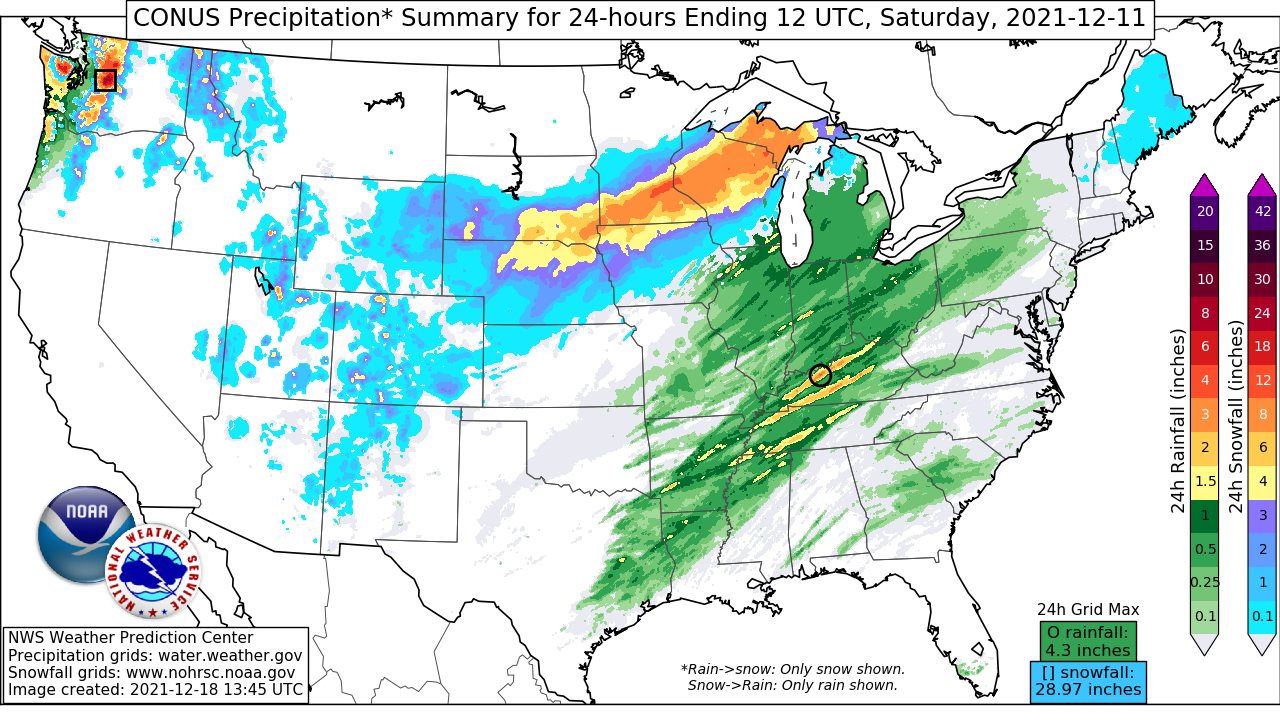
An impressive storm system produced heavy snow from the Great Basin and Four Corners, through the Central Plains, and into the Upper Midwest and Great Lakes between December 9 and December 12, 2021. This system was notable in that it brought the first measurable snowfall to Denver, CO (KDIA) and Salt Lake City, UT (KSLC) of the winter, ending their near-record streaks without snow. It also produced a swath of more than 6 inches of snow from the Black Hills of SD northeast through the Upper Peninsula of MI, including over 20 inches near the Twin Cities, MN.
The storm began as a shortwave moving onshore the Pacific Northwest December 9th and merged with secondary shortwave energy ejecting out of Alberta, Canada into a full latitude trough across the Intermountain West by December 10. As this trough sharpened, downstream upper level jet streaks strengthened, producing a coupled jet structure as the leading zonally oriented jet streak stretched into the Great Lakes while a poleward surging jet streak arced into the Central Plains. The overlap of the right-rear quadrant (RRQ) of the leading jet streak with the left-front quadrant (LFQ) of the trailing jet produced intense upper diffluence collocated with the rapid height falls ahead of the strengthening mid-level trough. As these features moved eastward, a surface low developed in the lee of the CO Rockies early on Friday (December 10). During December 10 and into December 11, the mid-level trough tilted negatively, and the overlap of rapid height falls, mid-level divergence, and upper diffluence led to a rapidly deepening surface low, with sea level pressure (SLP) falling to as low as 974mb over Ontario, Canada by 21 UTC on December 11.
As the surface low deepened, moisture increased rapidly across the Central Plains and Upper Midwest. Moist advection was driven by both Pacific jet energy aloft and through low-level warm air advection (WAA) surging out of the Gulf of Mexico, noted by integrated vapor transport (IVT) reaching the 99 percentile into the Upper Midwest. The accompanying theta-e ridge lifted northward and westward as a TROugh of Warm Air Aloft (TROWAL) expanded around the developing low pressure.
The overlap of deep synoptic ascent and impressive moisture produced an expanding area of precipitation across the Central Plains and into the Upper Midwest. While moisture was plentiful across the Rockies and other terrain of the Four Corners, the most robust moisture plume was east of the terrain thanks to southerly flow originating from the Gulf of Mexico. As the low moved northeast, mesoscale ascent became intense through mid-level frontogenesis and surging instability, producing convective bands of snowfall that included lightning, thunder, and snowfall rates that reached 2 inches per hour. This was most prevalent across MN and WI, and led to the non-terrain storm maximum snowfall of 21 inches to be measured just east of St. Paul, MN.
By Saturday evening, December 11, the low became vertically stacked and occluded to a new center north of New England. Immediately in the wake of this system, cold air advection (CAA) moving across the still warm waters of Lake Superior and Lake Michigan led to some lake effect snow (LES) enhancement across the Upper Peninsula of Michigan and NW portions of the Lower Peninsula. However, this LES was short-lived as mid-level shortwave ridging blossomed across the Plains and into the Upper Midwest, bringing an end to the snowfall associated with this system by the morning of December 12.
Impacts:
Heavy snowfall spread from the Great Basin on December 9 through the Upper Peninsula of Michigan on December 11. Snowfall of more than 20 inches occurred in the higher terrain of the CO Rockies, and locally exceeded 30 inches in the Sierra Madre of WY. Denver, CO received its first measurable snowfall of the season, observing 0.3 inches, while Salt Lake City, UT also received its first measurable snowfall of the winter, finishing the day with 1.4 inches.
Further to the northeast, the heaviest snow band began in the Black Hills of SD, where 20 inches was measured in Hot Springs. From there, the heavy snow spread across the SD/NE border and then pivoted northeast along the IA/MN border, into WI, and then into the U.P. of MI. Snowfall reached 11 inches in Nebraska, 21 inches in Minnesota, 18 inches in Wisconsin, and 14 inches in Michigan. Many locations received more than 6 inches of snow.
This heavy snow led to significant travel disruptions across the area, the worst of which was in MN/WI due to snowfall rates that reached 2 inches per hour. MSP airport briefly shut down during the height of the storm, and Interstate 35 was closed for a time on Friday near Fairbault, MN due to a 7-car accident, one of 286 crashes reported by the MN Department of Transportation (DOT). The Utah DOT reported more than 200 accidents during the storm.