


| March 30 2023 |
West Coast to Upper Midwest Winter Storm: (3/27/23 - 4/1/23)
By: Peter Mullinax, WPC Meteorologist
Meteorological Overview:
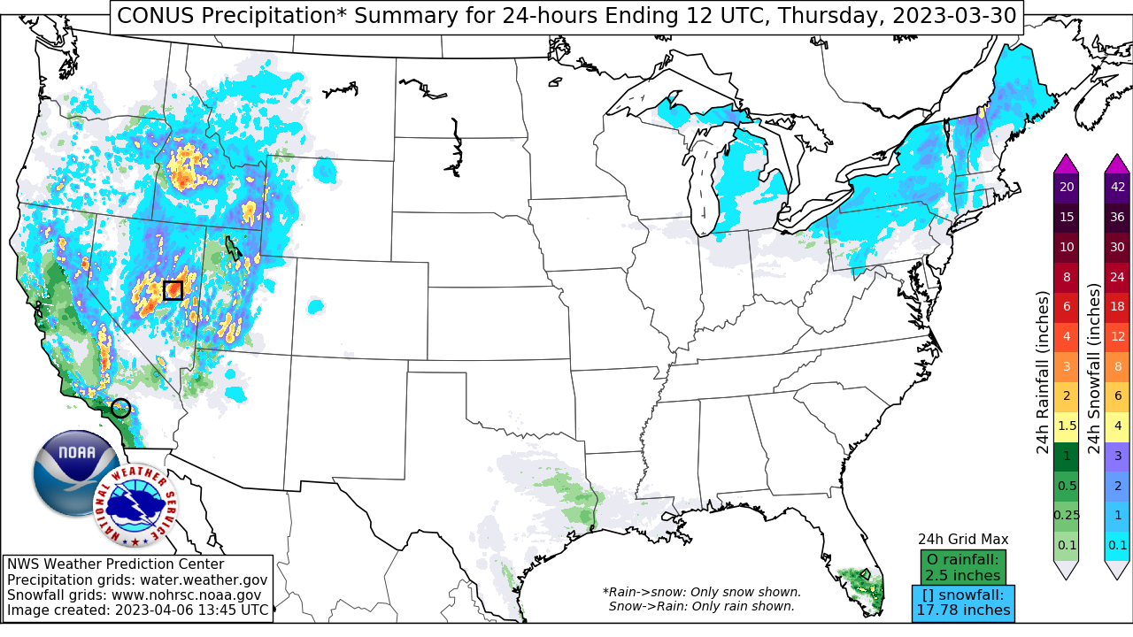
On March 27, an upper low in the northeast Pacific began strengthening as it approached the Pacific Northwest. By 18Z March 27, the upper low had spawned a 1000mb surface low off the Pacific Northwest coast that was steadily deepening into the evening hours. As the upper low approached later that night, the minimum barometric pressure plummeted to 980mb later that night and ushered in a slug of Pacific moisture. Periods of coastal rain from northern California to western Oregon ensued with rounds of moderate-to-heavy snow from the Shasta and Trinity Mountains of northern California on north into the Oregon Cascades.The left exit region of a 250mb jet was providing excellent vertical ascent aloft into the morning of March 28 and, with a robust atmospheric river delivering copious amounts of moisture aloft and falling snow levels, heavy mountain snow took shape in the northern and central Sierra Nevada. Snowfall was measured in feet in the mountains of northern California, particularly in the Sierra Nevada where 2-4 feet of snow prompted numerous road closures and only added to the Sierra Nevada’s near record snowpack.
On March 29, as the occluded low pressure system pressed into California, a new area of low pressure formed along a strengthening frontal axis over Nevada. The wave of low pressure formed beneath the aforementioned left exit region from the 250mb jet while the slug of Pacific moisture worked its way north and east into the northern Rockies and the Great Basin. Farther south, the anomalously low heights and colder than normal temperatures led to heavy snowfall in the southern Sierra Nevada and the Transverse Ranges. The upper trough that was responsible for the onslaught of heavy mountain snow in the Sierra Nevada and Great Basin made its way into the Southwest by March 30. The storm system was traversing the Rockies the morning of March 30 at the same time as an Arctic high pressure was entrenched over the northern Plains and Upper Midwest. Farther south, as pressure falls continues in the High Plains, a strengthening low level jet in over Texas stretched northward and delivered additional moisture for the newly formed storm system in the central High Plains to utilize. By the evening of March 30, a well organized area of low pressure in northwest Kansas was tracking northeast while a deepening 700mb low emerged from over central Wyoming. Snow was falling heavily in portions of the Intermountain West throughout the day in the Wasatch and both the northern and central Rockies, but the emergence of the 700mb low led to moisture wrapping around the mid-level circulation and causing heavy snow to envelop the Black Hills and Badlands the night of March 30. By March 31, a warm conveyor belt of moisture associated with the strong low level jet had revolved around the northern and western flank of the storm system positioned over eastern Nebraska, resulting in a deformation axis of heavy snow setting up over central South Dakota.
The winter storm only continued to deepen throughout the morning and afternoon of March 31 thanks in large part to jet coupling at 250mb fostering exceptional upper level divergence over the Midwest and Central Plains. The 500mb vorticity maximum closed off into a robust upper low and by 00Z April 1, the 850mb low was located over southeast Minnesota. The strong low level jet out in front of the winter storm and dome of Canadian high pressure to the north led to an ideal setup for intense 850mb frontogenesis over southern Minnesota and central Wisconsin. It was just north of this 850mb front where hourly snowfall rates as high as 2”/hr occurred the evening of March 31 and continued into the early morning of April 1. The winter storm sped up on April 1 with the bulk of the snowfall occurring over Michigan’s Upper Peninsula where there was the added element of Lake Superior enhanced snow bands. Snow began to dissipate the afternoon of April 1 as the storm raced into southern Ontario.
When all was said and done, heavy snow blanketed much of the western U.S. and into the Upper Midwest. WPC’s final storm summary saw snowfall amounts ranging between 10-16” in central and northeast South Dakota, 6-12” in south-central Minnesota, 12-19” in north-central Wisconsin, and 12-22” in Upper Michigan. These snow amounts only continued to boost an already exceptionally snowy winter season from California to Upper Michigan. Minneapolis-St. Paul International Airport measured 8.5” for the storm, bringing their seasonal snowfall to 89.7” as of the end of this winter storm. This made the 2022-23 season the third snowiest on record for the Twin Cities. Wind gusts ranged between 40-55 mph in South Dakota according to the Aberdeen, SD WFO during the day and into the evening hours on March 31. They also reported ice accumulations over a quarter inch in their northeastern most counties of South Dakota.
Impacts:
The winter storm initially led to road closures in some passes of California’s Sierra Nevada March 27 and into March 28. Some specific examples included sections of I-80 in the Sierra Nevada which were closed due to multiple vehicles spinning out, and a box truck overturning northeast of Sacramento where heavy snowfall rates led to significantly reduced visibility. This winter storm prompted the governor of California to expand a state of emergency to 43 counties according to the L.A. Times due to not only the heavy snow, but due to this storm system further exacerbating the threat for avalanches, landslides, flooding, and debris flows. The combination of strong wind gusts topping 60 mph and heavy snow weighing down tree limbs and power lines resulted in more than 22,000 customers in California losing power.
In the Midwest, heavy snow and whipping wind gusts that caused whiteout conditions prompted the issuance of blizzard warnings from central South Dakota on east to the Twin Cities metro area into central Wisconsin on March 31 and into early April 1. The increased snow load and strong winds led to as many as 280,000 customers losing power in Minnesota and Wisconsin combined, along with numerous road closures and hundreds of vehicle accidents. South Dakota DOT closed portions of I-29 and I-90, while the state government closed its offices in dozens of counties. Many school districts and some universities also canceled classes across South Dakota, giving students a 3-day weekend with March 31 falling on a Friday.