


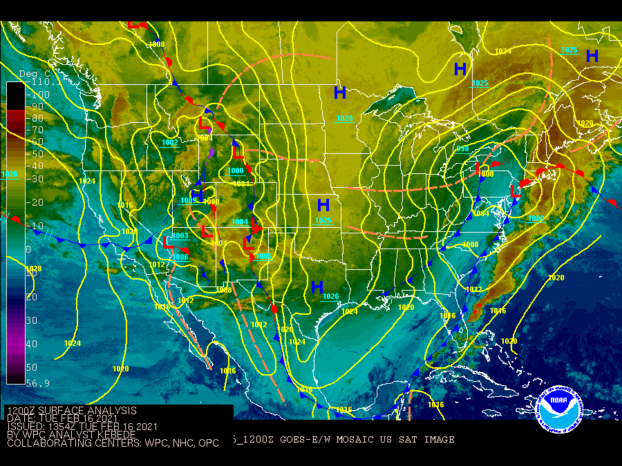
| February 16 2021 |
Southern Plains to Great Lakes Winter Storm: (2/14 - 2/16)
By: Bryan Jackson, WPC Meteorologist
Meteorological Overview:
A sprawling major winter storm spread east across the southern Great Plains on February 14 before turning northeast and crossing the Mid-South, Midwest on the 15th and lifting over New England into the Canadian Maritimes on the 16th. Heavy snow, sleet, and freezing rain impacted broad swaths of the southern, central, and northeast portions of the country causing great disruption to commerce and daily life. However, it was the combination of this wintry precipitation and the exceptionally cold air that followed this storm, which spilled down the length of the Great Plains and into the Gulf of Mexico which made this perhaps the most impactful winter storm in a generation.
The coldest period of the North American 2020/2021 winter began for the northern Great Plains on February 5 in association with an initial lobe of a cold vortex that set up over Manitoba/western Ontario and maintained particularly cold air over central North America into February 20. Through the first week of this cold period, a zonal northern jet stream across the north-central CONUS generally contained the coldest air north from the northern Great Plains, though subfreezing air did spill south down the Great Plains reaching Texas February 8. Beginning on February 12, a pair of amplifying shortwave troughs from the north Pacific set off the greatest southern progression of the particularly cold air.
Early on February 12 a shortwave trough dug southeast from northern California, reaching northern Mexico early February 13 where it briefly closed and slowed to a drift south of the Big Bend of Texas. Low level flow from the Gulf drew elevated moisture west over Texas toward this low. A much stronger reinforcing trough in a rapidly strengthening northwesterly jet shifted southeast from the Pacific Northwest on February 13, expanding into a large trough (with a low centered at 700mb over the Utah/Colorado border) with its southern axis crossing south of New Mexico on the 14th. The now 150+ knot jet digging down the entirety of the western CONUS on the 14th tilted the downstream jet more southwesterly which dislodged the parent low (the cold vortex) east over Ontario, allowing the second and now dominate trough to have its axis down the entirety of the Great Plains by the 15th. Aided by a broad downstream ridge helping the cold vortex shift east to the north of the Great Lakes, the western trough took on a negative tilt late on the 14th, allowing further development, most notably with low level cyclogenesis in the lee of the Sierra Madre Oriental by 00 UTC on the 15th. This sprawling low pressure system lifted northeast from south Texas to the Mid-South states on the 15th which expanded the southerly inflow to span the Gulf of Mexico and draw copious moisture into the developing system. Overnight from the 15th into the 16th the low tracked northeast from the Midwest, across the eastern Great Lakes to northern New England.
Impacts:
In advance of this western low, winter storm warnings were issued, which by late on February 14 extended from southern New Mexico, included the entirety of Texas, Oklahoma, and Arkansas to the Great Lakes and northern New England, covering ~618,000 square miles which is the largest such area of the country over the past 15 years, eclipsing the winter storm warning coverage from February 1, 2011 by ~463,000 square miles.
Bands of snow spread from eastern New Mexico across western and northern Texas through Oklahoma on the 14th ahead of the western low (which had been moistened by the leading low/trough) with heavy snow developing on the southern end of the precipitation shield along a low level boundary across west Texas from Midland/Odessa through San Angelo and Abilene that afternoon. Generally 5 to 10 inches were reported along this southern swath. The 9.8 inches reported at Abilene set a new record for highest total snowfall of all time (period of record back to 1885), topping the 9.3 inches recorded on April 5, 1996. The 10.1 inches reported in San Angelo was the largest calendar day snowfall on record (period of record back to 1907), though the 4th largest when considering two-day snowfalls.
The main northeasterly low developed over south Texas the night of the 14th and caused a new swath of heavy snow to develop over northern Mexico which pushed into Texas near Del Rio around 00 UTC on the 15th and then expanded and intensified as the system rapidly pushed northeast across the Mid-South and the Midwest through the evening of the 15th before turning east across the eastern Great Lakes and northern New England into the 16th.
Generally 4 to 6 inches fell in about six hours in a swath from Eagle Pass to San Antonio which is remarkable for this area of interior southern Texas. In fact the 2.4 inches recorded in Del Rio was the 10th highest calendar day snowfall (period of record back to 1915) and this snow along with record heavy snow on February 18 (11.2 inches in Del Rio is the new highest snowfall of all time) made for the snowiest month and season on record for Del Rio and likely across the immediate area. Del Rio had not observed more than an inch of snow in a single day since 1993.
A broadening swath of heavy snow with an area of continuous 6 or more inches fell on the 15th from San Antonio to the eastern Dallas metro area and northeast across the ArkLaTex, the northern Mississippi River Delta, through the central Midwest with more areas over 6 inches along the eastern Great Lakes and northern Maine through the morning of the 16th. Measurable snow on the ground was estimated to cover 73.2% of the CONUS on February 16 which is the highest daily coverage in the NOHRSC snow cover database which began in 2003. The 7.7 inches of snow that fell in Little Rock on the 15th was their 13th highest calendar day snowfall on record which is notable, but was followed up two days later with 11.8” making for the snowiest three day period on record by more than six inches.
The 6 to 12 inches of snow that fell from southeast Missouri and southern Illinois up through southern Michigan (with locally high amounts from Great Lakes enhancement which will be discussed next) is notable (the 10.1 inches that fell at Ft. Wayne on February 15 is the 9th highest calendar day snowfall for records dating back to 1897), but the breadth of heavy snow is quite remarkable. In fact, the 24 hour period from 12 UTC February 15 to 12 UTC February 16 is estimated to have the 8th largest percentage of the CONUS (4.4%) covered by 6 or more inches of snow in 24 hours since NOHRSC daily snow amount estimates began in 2008. The day with the highest such snowfall coverage was February 2, 2011 with 6.1% of the CONUS. Near shore residents from far northwest Indiana, Chicago, and up to Racine, Wisconsin were likely reminded of the Groundhog Day Blizzard of 2011 from this event because local enhancements from northeasterly winds off Lake Michigan produced a narrow strip of 15 to 18 inches of snow within about 10 miles of the lake (most of which fell the night of the 15th). There had already been over a foot of snow on the ground since heavy snow in late January and this brought snow depth in the city of Chicago to over two feet. Areas farther west from the lake received less than 8 inches including O’Hare airport with 7.5 inches. As a comparison, the broad heavy snow coverage on February 2, 2011 was centered on Chicago with O’Hare receiving 20.2”, their third highest calendar day snowfall with records dating back to 1884. Similar enhancements were noted in the northeasterly flow off Lake Huron with around 15 inches reported near Port Huron, Michigan on the 16th.
The broad influx of Gulf moisture over the antecedent cold surface air (from the persistent cold vortex) caused broad areas of sleet and freezing rain east of the snow swath. A mix of sleet and freezing rain was reported on the morning of 15th from the lower Rio Grande Valley across the Houston metro with local reports of one to two tenths inch of freezing rain south from San Antonio to Kingsville. A broad area of mostly sleet occurred north from Houston with a swath of 1 to 3 inches of sleet reported across central portions of Louisiana, Mississippi, Tennessee, and Kentucky with local maxima of 4 to 4.5 inches of sleet reported in west-central Mississippi and far northeast Louisiana. A swath of freezing rain occurred east of the sleet and along the entirety of the low track with quarter inch ice reports from interior eastern Louisiana across southeast Mississippi, northwestern Alabama, east-central portions of Tennessee and Kentucky, then along the upper Ohio River across Pennsylvania, Upstate New York and central New England. Freezing rain accumulations of a 0.5 to 0.75 inches were reported from northeast Pennsylvania through southern New York including the Albany metro.
At least 3088 daily low temperature records (record low minimum or maximum) were tied or broken from February 12 to 17 at stations in the CONUS with at least 75 year long periods of record. A total of 76 all-time cold temperature records (again low minimum or maximum) were tied or broken at stations with at least 75 year long periods of record on February 15 or 16 from Nebraska to Texas. This cold outbreak is thought to be the most extreme for the southern Great Plains since February 12, 1899. There were far fewer stations reporting in 1899 when Oklahoma City hit -17F and Dallas hit -8F, but both locations set or tied second coldest temperatures on February 16, 2021 (-14F OKC, -2F Dallas). South-central and southeast Texas saw their coldest temperatures on February 15 or 16 since a particularly cold outbreak in December 1989 including Austin, San Antonio, Corpus Christi, Houston, College Station, Beaumont, and Lufkin. The length of cold was also extreme with Oklahoma City setting their longest stretch of temperatures below 20 degrees (6 days) while the 10 such days in Wichita are second only to 11 days in February 1899. Dallas recorded 139 consecutive hours below freezing from February 13 to 19.
The heavy snow and ice followed by near record cold led to extensive strain on the electrical grid of the southern Great Plains and forced many power plants offline and resulted in rolling power outages across the central and southern Great Plains to the western Gulf Coast. Texas was particularly impacted with cascading effects beginning with the heavy snow over west Texas on February 14 that resulted in over 100,000 customers without power by that evening and the south Texas snow and ice raising the number without power early on February 15 to over 1 million customers. The subsequent cold (with much of Texas below 10F the morning of the 15th) caused over 4 million customers to be without power from later February 15 into February 17. This caused cascading effects including widespread municipal water failures and the lack of power is the main driver of the estimated economic impact exceeding $10 billion. At least 58 people over eight states (including 32 in Texas) are reported to have died as a result of this winter storm and its prolonged after effects. This storm and cold outbreak disrupted COVID-19 vaccine deployment and administration with over 200,000 vaccine appointments cancelled in north Texas alone the week of February 15.