


| March 15 2021 |
Central Rockies & High Plains March Snowstorm: (3/13 - 3/15)
By: Peter Mullinax, WPC Meteorologist
Meteorological Overview:
The primary weather feature responsible for this historic mid-March major winter storm was a potent upper level low over the Southwest U.S. On Friday, March 12, the upper low produced periods of heavy mountain snow in the higher elevations of northern Arizona and southern Utah, culminating with over a foot falling in Utah’s Pine Valley mountains. By Saturday, March 13 the upper low began to transition from exhibiting a positively tilted trough axis to a more neutral tilt. This fostered a more favorable environment for upper level diffluence over the central Rockies and central High Plains. Farther east, a dome of high pressure over the Midwest supplied just enough cold air to support snow in these regions as precipitation broke out Saturday afternoon. In addition to the snow, severe weather also erupted out ahead of the approaching cold front in the Texas Panhandle. Reports of tornadoes, large hail, damaging winds, and localized flooding came in across the area, as well as portions of western Oklahoma.
Saturday night saw a roaring low level jet usher in copious amounts of Gulf of Mexico moisture into the Southern Plains that became oriented toward the front range of the Rockies. Upsloping flow perpendicular to the mountain range in Colorado and Wyoming led to stronger vertical motion within the atmospheric column, which in turn produced dynamic cooling aloft and intensifying snowfall rates. In addition, deepening surface pressure with help from strong upper level divergence aloft and topographically-induced lee cyclogenesis east of the Rockies caused a tightening of the pressure gradient, resulting in a strong and expansive wind field. By the morning of Sunday, March 14, blizzard conditions were common in southeast Wyoming and western Nebraska while periods of heavy snow continued to fall across the Denver-Boulder metro areas.
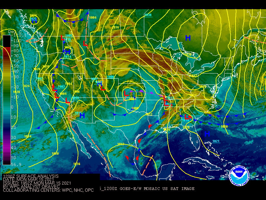
Sunday morning’s surface analysis depicted an intensifying surface low in eastern Colorado with room for additional strengthening as the upper level low was not yet vertically stacked according to SPC upper air maps at 12Z. This massive cut off upper low became nearly stationary throughout the day, continuing to direct a plume of Gulf of Mexico moisture at the Rockies and central High Plains. Heavy snow continued to pile up into the evening hours on Sunday as far north as southern South Dakota and northern Nebraska. By late Sunday night, the occluded storm system began to weaken and a Pacific storm system diving into the Northwest began to help push the winter storm east into the Mississippi Valley by Monday. This effectively ended the major winter storm for the central Rockies and High Plains. Strong high pressure over the Great Lakes kept temperatures below freezing in the Midwest and helped to produce a swath of 4 to 8 inches of snow from southern South Dakota and Minnesota to northern Iowa.
Impacts:
Treacherous travel conditions were observed as far west as Arizona on Sunday morning with several crashes and lane closures due to icy roads. Whiteout conditions and pictures of towering snow drifts were frequently reported by local TV stations through various social media channels. In fact, on the evening of March 14, the NWS Cheyenne office mentioned that some snow drifts were an astonishing 5-10 feet tall. Wind gusts in excess of 50 mph and snowfall rates of 2 to 3 inches per hour made for stifling blizzard conditions.
There were numerous snowfall records that were broken as a result of this storm. Denver International Airport reported 27.1 inches of snow for the duration of this storm, making it the fourth-biggest snowstorm in Denver dating back to 1881. Farther north, Cheyenne, WY airport measured 30.8 inches of snow, 22.7 inches of which fell on March 14 and thus made it the city’s single snowiest day on record. The March snowstorm became the 4th snowiest on record in Scottsbluff, Nebraska where a 3-day total of 18.0 inches was reported. The last time Scottsbluff picked up more than 18 inches of snow in 3 days was in April 1927. The highest reported snowfall total came near Windy Peak, located along the Laramie Range, with an incredible 52.5 inches. The highest reported snowfall total in Colorado was near Buckhorn Mountain where 48.5 inches of snow accumulated. Over two feet of snow piled up in parts of western Nebraska, southwest South Dakota, and eastern Utah.
Roads were impassible not only during the event, but the feet of snowdrifts blanketing highways and side roads led to school systems in Colorado to be closed on Monday and teach remotely on Tuesday. Schools were also closed in parts of eastern Wyoming through the first half of the week. The governor of Wyoming announced state facilities and offices in Laramie county, as well as the state legislature, would not meet on Monday. Dangerous travel conditions were felt as far east as the Upper Midwest as hundreds of automobile accidents were reported in Minnesota alone on Monday. Air travel was significantly impacted at Denver International Airport where more than 3,000 flights were canceled in total from the weekend into the first half of the week. In addition, power outages were also common with more than 54,000 homes and businesses without power Sunday afternoon.
Detrimental impacts were felt in the U.S. Postal Service too due to the staggering number of closed or impassable roads. The good news is that COVID-19 vaccines were only delayed by one day and any vaccination appointments that were scheduled for Monday could be rescheduled that Tuesday.