


| January 24 2023 |
Southern Rockies to New England Winter Storm: (1/23- 1/26)
By: Tony Fracasso, WPC Meteorologist
Meteorological Overview:
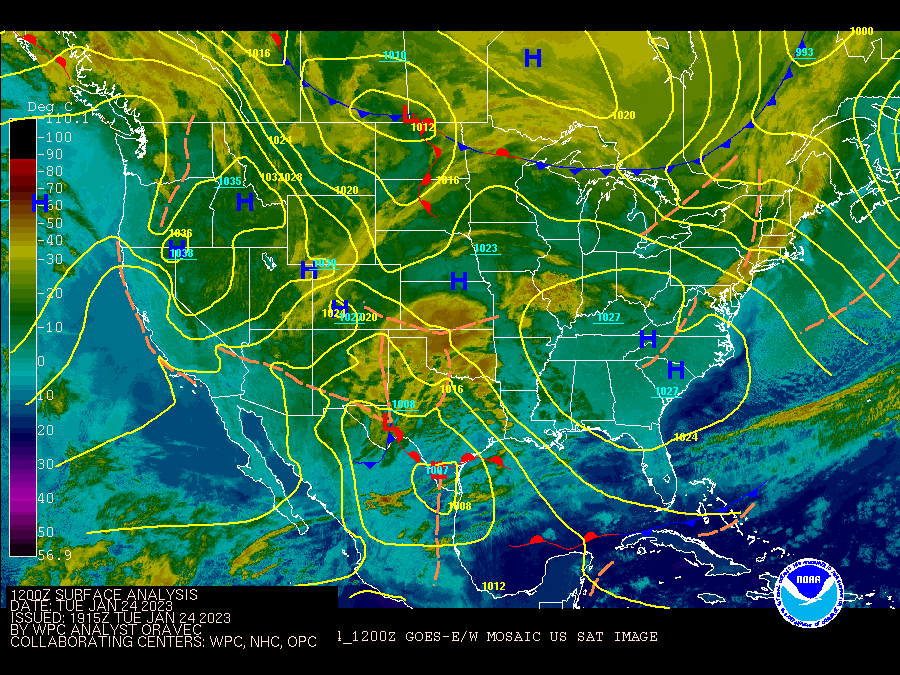
A long-lived winter storm traveled from the Rockies to the Northeast during late January with modest snowfall along its path and a variety of impacts. On Sunday January 22nd, a closed 500mb low dropped southward through the northern Rockies, along with a surface cold front. Generally light snow spread across the central Rockies into the higher terrain of the Four Corners region. By the morning of the 23rd, the mid-level closed low dropped into Arizona and turned eastward across northern Mexico, bringing in colder temperatures and windy conditions. Heavy snow fell over the Mogollon Rim of Arizona and into the mountains of New Mexico. Due to the cold temperatures associated with the storm, snow levels dropped down to some valley floors where a dusting to a few tenths of an inch of snow was observed within about 45 miles from Phoenix and flurries were seen around Tucson. Low pressure continued to organize over New Mexico and move into far west Texas by Monday evening. An expanding area of rain to the south and snow to the north spread eastward across the southern Plains, including the Lubbock area which received 7.2" of heavy wet snow. This was the first widespread snowfall of the season for that region.
On Tuesday the 24th, the surface low moved through the Rio Grande Valley into South Texas and then into Louisiana overnight. Snow overspread Oklahoma to the north of the low track. As the low lifted northeastward into the Mid-South by the morning of the 25th, snow expanded into the Ozarks through southeastern Missouri. Many areas saw several inches of snow, with parts of Missouri and Arkansas receiving over ten inches of snow. Fayetteville, AR recorded 8.5" of snow.
The surface low continued to deepen as it moved into the Ohio Valley on Wednesday morning, and across Ohio during the afternoon. Light to moderate snow fell across parts of the Midwest, including 8.5" at Fort Wayne, IN and 5" in Peoria, IL. The surface low continued on a northeast path into Thursday, where it reached maximum intensity of 993mb near Niagara Falls. Snow overspread much of Lower Michigan where six to ten inches of snow was common in the Detroit and Ann Arbor areas.
By Thursday morning, the triple point area of low pressure near southeastern New York and southern New England began to take over as the main area of low pressure, with milder air overrunning a surface warm front along the coast. A wintry mix developed across much of the interior Northeast where about a tenth to a quarter of an inch of ice was reported from northeastern New York eastward to northern Maine. Snowfall was focused away from the coast, with several inches reported over West Virginia into parts of Pennsylvania, and six to ten inches of snow across northern New York, Vermont, and New Hampshire. As the new surface low reorganized over the Maine coast early Thursday, heavy snow was reported across interior Maine while the low intensified to 981mb near Caribou midday. Many areas of northern Maine received around a foot of snow.
Impacts:
The heavy snow and windy conditions over parts of the Southwest resulted in road closures and stranded drivers along I-17 near Camp Verde between Phoenix and Flagstaff. As the storm moved across the Plains to the Mid-Mississippi Valley, temperatures were near freezing which promoted a heavier and wetter snow. This was common from the Texas Panhandle northeastward to the Great Lakes. Though windy conditions were not as prevalent east of the Rockies, there were still areas that saw gusts of wind over 20 mph which was enough to cause some power outages as the snow stuck to trees quite easily and resulted in many broken branches and some downed trees. On the morning of the 25th, there were nearly 100,000 customers without power across south central and southeast Missouri into northern Arkansas.
Impacts were modest across the Midwest to the Northeast, but did affect the commutes across area cities since this storm occurred during the work week. Some roads were closed at times across Lower Michigan as snowfall rates exceeded 1"/hr. Many accidents were reported across northern Ohio along with some power outages affecting a few thousand people. Some area schools closed due to the snow and poor travel conditions. Across Maine, the additional snow from this storm added to previous snowfall earlier in the week, leading to some roof leaks and collapses. The snow was also responsible for some power outages of several thousand customers across central Maine.