


| February 01 2023 |
Southern Plains to Mid-South Ice Storm: (1/30 - 2/2)
By: Rich Otto, WPC Meteorologist
Meteorological Overview:
A multi-day winter storm affected a large portion of the southern Plains into the Lower Mississippi and Ohio Valleys from January 30 to February 2, 2023. While the storm produced areas of light snow and sleet, the accretion of ice from freezing rain was the most noteworthy aspect of this storm system. Significant impacts occurred across Texas into portions of Arkansas and Tennessee due to ice accretion of 0.25 to over 0.50 inches. The greatest ice accretion occurred across sections of the Texas Hill Country with reports of 0.70 to 0.80 inches of ice.
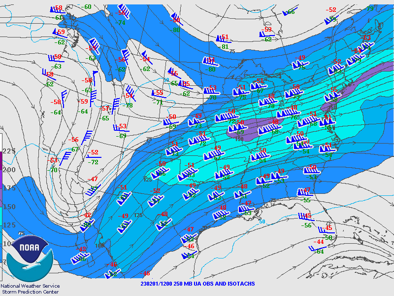
The storm began as an arctic cold front moved southward across Oklahoma and Texas early in the morning on January 29. At 500 mb, an anomalous ridge (positive standardized geopotential height anomaly of 2 to 3) was located in the Gulf of Alaska while to the east; an anomalous closed low (standardized geopotential height anomaly of minus 2) was located over northern Hudson Bay. A number of shortwaves dropped south between the two 500 mb height anomalies which helped to lower mid-level heights across the western continental U.S. from January 27-29. As mid-level heights lowered over the western U.S., an arctic air mass dropped southward through the Great Plains with surface temperatures in the wake of the cold front containing mean departures from average of -20 to -30F, which spread across the western and central U.S. through the last few days of January. By early January 30, a closed 500mb low developed over the central coast of California with a mean southwesterly flow extending from the Baja Peninsula, through the southern Plains, into the middle Mississippi Valley, and to the East Coast. Embedded weak shortwaves within the flow helped contribute to the development of waves of precipitation across the southern U.S. over the next couple of days. A series of jet streaks centered near 250mb ejected northeastward through the central U.S., emanating from lower mid-level heights over northwestern Mexico, with the right entrance region of the jet streaks contributing to the enhancement of precipitation across the middle of the nation.
The first wave of wintry precipitation began around 12Z on January 30, as areas of snow, sleet and freezing rain expanded across northern Texas into Oklahoma as warm air aloft (maximum temperature just over 10oC in the 850-700 mb layer) overran sub-freezing temperatures in place at the surface. An interesting observation of thundersnow at OKC was reported between 14-17Z on January 30, with a surface temperature of only 17F, supported by weak elevated instability above 700 mb as seen in the 12Z sounding from OUN. Heavier values of base reflectivity on area radar coincided with an axis of 850 mb frontogenesis that extended from northern Texas into eastern Oklahoma. Sleet accumulations across northern Texas into eastern Oklahoma ending 12Z on January 31 ranged up to one inch with localized totals up to two inches. Reports of freezing rain with accretion values up to 0.25 inches were observed across the Texas Hill Country as well as Arkansas into far western Tennessee prior to the axis of precipitation translating toward the east-northeast late in the day on January 30.
A second wave of wintry precipitation started shortly after 12Z on January 31, with a shield of precipitation that extended from southwestern to northeastern Texas. Similar to the day before, the precipitation axis aligned near an elongated region of 850 mb frontogenesis that was located from Texas into southern Arkansas and southeastern Missouri. Despite sub-freezing temperatures at the surface, the 12Z sounding from FWD indicated a sizeable elevated layer of above freezing temperatures that measured almost 2000 m deep, with a maximum temperature of 10oC located just above 850 mb, which ensured freezing rain as the dominant precipitation type for the region during the day.
A third and final wave of precipitation began around 06Z on February 1 as the closed 500 mb low over northwestern Mexico moved east-northeastward over northern Mexico while opening up. Downstream winds in the 850-700 mb layer over southern Texas increased in magnitude supporting increased overrunning of the cold air mass in place at the surface, spreading a combination of freezing rain and sleet over the southern Plains into the lower to middle Mississippi Valley. The sounding from FWD on 00Z on February 2 showed a much shallower sub-freezing layer at the surface, extending up roughly 500 m, approximately half of what was observed on soundings from previous days. The shallower sub-freezing layer allowed reports of mostly freezing rain across Texas for the third wave of precipitation. As the 500 mb trough axis moved east through 00Z on February 3, the main shield of precipitation exited out of Texas across the Mississippi River Valley. Surface temperatures warmed above freezing for most locations in Texas during the day on February 2, marking an end to the ice storm, with light rain showers passing over portions of north-central Texas as the mid-level trough crossed the region.
Impacts:
The highest ice accumulations occurred from the Austin metropolitan region into the Hill Country and locations north of San Antonio where several 0.50 to 0.80 inch reports were received. Power outages were widespread across this region of Texas during the height of the storm with over 400,000 customers without power in the Lone Star State alone on the morning of February 2. In total, over 500,000 customers lost power during the storm including Arkansas and northwestern Mississippi, a direct result of downed trees and power lines due to ice buildup from freezing rain.
The winter storm created icy roadways from the southern Plains into the Mississippi River Valley and resulted in hundreds of traffic accidents, including 10 fatalities. Portions of major highways across Texas and Arkansas were closed, including sections of Interstate 40 in eastern Arkansas. Other impacts to transportation included air travel with 2,300 canceled flights reported at one point during the storm. The storm also forced the closure of many schools and businesses across the southern Plains into the Mid-South.