


| January 17 2019 |
Western to Northeastern U.S. Winter Storm (16-20 January, 2019)
By: Frank Pereira, WPC Meteorologist
Meteorological Overview:
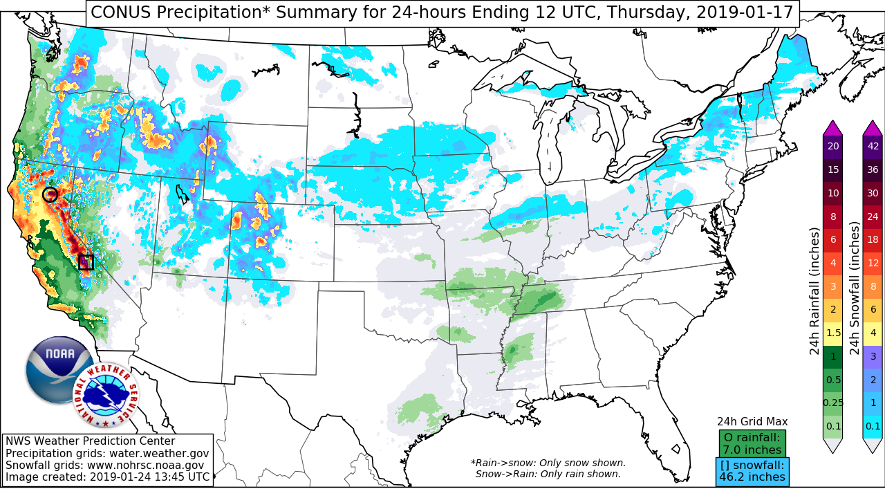
From 16-20 January, a winter storm moved across the U.S. – producing a widespread swath of snow and icy conditions that extended from the Mountain West to the Northeast.
On 16 January, an upper low moved across the eastern Pacific Ocean – approaching the Pacific Northwest coast. Although the low weakened and turned to the north, a strong upper jet digging south of the low carved out a well-defined upper trough that moved east across the western U.S. on 17 January. Winds gusting to hurricane force strength and mountain snow occurred across portions of the Pacific Northwest and California 16 January into early 17 January. Strong divergence along the left-exit region of the upper jet helped produce heavy snow along the Sierra.
As snow continued across the Sierra, heavy snow developed farther east across the northern and central Rockies on 17 January. Favorable upper jet dynamics helped generate heavy snow along the Utah and western Colorado ranges late 17 January into early 18 January. Meanwhile, southeasterly low level winds helped produce heavy snow farther to the north across the western Montana ranges.
As the broad scale upper level trough moved east across the Rockies into the High Plains, a low-to-mid level shortwave began to amplify and move east from eastern Montana and Wyoming into the Dakotas early 18 January. Southeasterly winds ahead of the wave drew warm air and low level moisture into a region of strengthening low level frontogenesis and upper level divergence – supporting a stripe of heavy snow that developed over eastern South Dakota into far southern Minnesota and far northern Iowa during the morning of 18 January. This band shifted east during the day, reaching into southern Wisconsin and northern Illinois during the afternoon and evening hours. The northern extent of this band was limited by a very cold and dry air mass spreading across the northern Plains and upper Midwest. Little to no snow was reported from eastern North Dakota to northern Minnesota, where temperatures fell and remained below 0 (F) on 18 January.
Meanwhile to the south, a well-defined southern stream shortwave developed and moved east of the central and southern Rockies into the High Plains 18 January. A surface low began to develop over the central High Plains, directing moisture behind a strong cold front dropping south through the central Plains and Rockies. This produced light to moderate snow along the Front Range during the morning of 18 January. As low pressure moved east into the Red River region, cold air continued surge south through the Plains. During the afternoon and evening hours, rain changed to light snow from western Kansas to the Texas Panhandle. As the upper level trough continued to amplify, strengthening southwesterly winds transported deeper moisture into a region of strong low level frontogenesis and upper level divergence – producing a band of heavier precipitation that transitioned to snow across eastern Kansas, northern Missouri and southern Iowa.
Surface low pressure tracked east across Arkansas early 19 January, reaching western Tennessee by the afternoon. As cold air continued to surge south, rain changed to snow from eastern Oklahoma through southern Missouri and northern Arkansas into southern Illinois, western Kentucky and western Tennessee. By late 19 January, increasing upper level divergence and strengthening low-to-mid-level frontogenesis produced a swath of moderate to locally heavy snow from northeastern Arkansas to southern Indiana.
The southern stream shortwave began to interact with the northern stream - lifting to the northeast as it tracked across the lower Ohio and Tennessee valleys late 19 January into early 20 January. Surface low pressure gradually intensified as it moved east across Kentucky. Southerly winds ahead of the shortwave directed warm, moist air over an arctic mass in place over the Great Lakes and Northeast. Increasing upper divergence along the right-entrance region of a strengthening jet helped to support a swath of light to moderate snow that developed over northern Ohio and spread east into Pennsylvania and the Northeast late 19 January. Snow continued and became heavy at times overnight from eastern Ohio to western and northern Upstate New York and northern New England. Farther south, as low level temperatures warmed, snow changed to sleet with freezing rain across portions of eastern Pennsylvania, the Catskills, Hudson Valley and southern New England. From New York City to Cape Cod, precipitation began as and remained mostly rain through the event.
By late morning on 20 January, an intensifying surface low was centered over southeastern Pennsylvania. The low continued to strengthen as it moved off of the northern Mid-Atlantic coast and tracked northeast across Long Island and southeastern New England during the afternoon hours. Meanwhile to the north, deep moisture advection interacting with low-to-mid-level frontogenesis and strong upper level divergence continued to produce periods of moderate to heavy snow across northern New York and New England.
By the afternoon hours of 20 January, as the better synoptic-scale forcing shifted farther east, snow came to an end across much of New York. However, strong winds backing to the north across Lake Ontario supported a period of heavy lake effect snow showers - bolstering snowfall accumulations across the Finger Lakes region of New York.
As the surface low tracked from the northern New England coast to Nova Scotia, Canada, snow gradually ended from west to east across northern New England late 20 January.
Impacts:
The heaviest snowfall accumulations produced by the storm were in the Sierra, where more than 4 feet was reported in some locations. In addition to the snow, high wind gusts and vehicle accidents resulted in the closure of Interstate 80 through the Sierra on 17 January. Nearly 100,000 power outages were reported across northern and central California due to the strong winds.
On 18 January, numerous vehicle accidents were reported in eastern Nebraska and northwestern Missouri, where light freezing rain created hazardous travel conditions. In Omaha, a Southwest Airlines plane slid off the runway after landing in icy conditions at Eppley Airfield. This resulted in the closure of the airport and the suspension of all flights. No injuries were reported.
Across portions of southeastern South Dakota, southern Minnesota and eastern Wisconsin, more than a foot of snow fell 18-19 January. Numerous vehicle accidents were reported across the region, including five reported collisions involving snow plows in Minnesota.
On 19 January, snowy conditions and reduced visibility resulted in several vehicle accidents in central and eastern Missouri, including a 15-car pileup on Interstate 55. Icy runway conditions resulted in another airport incident when a United Airlines plane slid off a runway while landing at Chicago’s O’Hare International Airport. No one was injured; however, firefighters had to assist the more than 100 passengers off the plane after it slid into a grassy area.
Heavy ice accretion resulted in downed trees and widespread power outages across portions of Connecticut and Massachusetts on 20 January, with local utility companies reporting nearly 30,000 outages in Connecticut alone.
More than a foot of snow fell from central New York to northern New England. The storm brought 16.9 inches to Caribou, ME - pushing its January snowfall total to the highest on record. The highest snowfall total in the Northeast was reported near Rochester, NY - with 29.2 inches observed.
On 20 January, more than 2,000 flights were cancelled and 10,000 flights delayed. Amtrak also delayed or cancelled rail service across the Midwest and Northeast.