


| December 12 2022 |
Coast-to-Coast Winter Storm: (12/9 - 12/17)
By: Zack Taylor, WPC Meteorologist
Meteorological Overview:
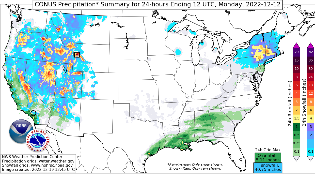
A large and impactful Coast-to-Coast winter storm brought significant accumulations of snow and ice to parts of the contiguous United States during the middle of December 2022. The storm began with an anomalously deep and potent upper trough dropping southward along the West Coast. This feature directed a deep plume of Pacific moisture at California where moisture and height anomalies were well above the 90th percentiles. The combination of the strong moisture transport and lowering snow levels brought intense and heavy snowfall to the terrain areas, particularly the Sierra Nevada which saw prolific snowfall rates exceeding 3”/hr. Over the coming days, the upper level low tracked eastward across the Great Basin and favorable forcing for ascent and falling snow levels due to the cold air mass in place led to widespread snowfall across much of the region’s higher elevations. By the time the storm wrapped up, snowfall was measured in feet across parts of the Sierra Nevada and the highest snowfall total reported in California was 70.0” near Sierra at Tahoe while many higher elevations of NV, UT, and ID had reports exceeding 2 feet.
As the system pushed east out of the Rockies, low pressure developed and deepened over the Plains before tracking northeast toward the Upper Midwest. Moisture wrapping northward around the system combined with the strong lift and cold temperatures in place to produce widespread heavy snowfall from the central Rockies toward the Northern Plains and northern parts of the Upper Midwest. As the leading edge of precipitation moved through the Upper Midwest, a transition zone of mixed precipitation including sleet and freezing rain occurred and brought a thick glaze of ice to parts of the region. The system was also characterized by having high moisture content which brought a wetter, more “cement” like snow. The area of low pressure then stalled over the Upper Midwest, becoming nearly stationary for several days. This led to a second phase of the storm with a prolonged period of moderate to occasional heavy snow wrapping around the system. By the time the system diminished several days later, snowfall accumulations totaled over 2 feet across parts of Nebraska, the Dakotas, and northeastern Minnesota including 24.0” near Chadron, NE, 28.4” in Lisbon, ND, and 24.0” near Duluth, MN. However, localized higher accumulations were found across western South Dakota in the Black Hills where 48.0” was recorded near Deadwood, SD.
Finally, as the system moved toward the East Coast, a secondary area of low pressure developed off the Mid-Atlantic coast before turning northward. Cold high pressure positioned over Quebec helped to funnel cold air down through the interior portions of the Northeast. While areas along the immediate coast were too warm for winter precipitation, heavy snowfall fell from northern Pennsylvania through the interior Northeast and New England while cold air wedged up against the Appalachians led to localized freezing rain and ice accumulations across parts of the central Appalachians. A swath of 6”+ of snow fell from northern Pennsylvania toward Maine with the highest totals between 18-24” reported across portions of the Adirondacks, the Green and White Mountains of Vermont and New Hampshire and upstate Maine. Pinkham Notch, NH reported 31.0”, Stoney Creek, NY received 28.0”, and 26.0” was observed in Landgrove, VT. Ice accumulations between 0.25” and 0.50” were reported across parts of the region, including 0.40” in Frostburg, MD and near 0.50” in Emporium, PA.
Impacts:
As the system moved through the West, it brought significant and intense wind gusts to parts of the region with many locations reporting gusts in excess of 70-80 mph. The highest wind gust reported was 103 mph at the Heavenly Ski Summit in California. In addition to the widespread travel impacts and disruptions brought about by this winter storm, the unusually “wet” or low snow-to-liquid ratio of the snowfall led to extensive impacts to trees and power lines due to the heavy load. Across portions of the Northern Plains and Upper Midwest, extensive tree damage was reported with downed trees and broken tree limbs. This also led to considerable power outages and disruptions as well as blocked roads and highways that took several days to clear out by transportation officials. The strong low pressure system resulted in a large area of blizzard conditions of near zero visibility due to the strong winds that accompanied the storm. Wind gusts 50 to 60 mph were reported across parts of the Dakotas which produced total whiteout conditions and near impossible travel. As the system moved into the Northeast, the heavy snow and ice accumulations resulted in hazardous conditions and widespread travel disruptions as well as sporadic downed tree limbs and power outages.