Tropical
Cyclone Rainfall in Florida
|
|
This page is under
construction...so new information will be added as time allows. Data is
available for tropical and subtropical cyclones that impacted Florida from
1956 onward, as well as several older storms. Please select the storm
of your choice from the following list: |
A
|
14.65 |
Hart Lake |
|
|
6.20 |
Fernandina Beach |
|
|
8.97 |
Naples |
|
|
16.47 |
Tavernier |
|
|
21.38 |
Niceville |
|
|
7.08 |
Tarpon Springs 5 E |
|
|
11.80 |
Taylor Creek |
|
|
13.48 |
Lake Placid 2 SW |
|
|
5.15 |
Immokalee |
|
|
7.69 |
Everglades |
|
|
13.21 |
Bristol 2 S |
|
|
4.86 |
Okeechobee |
|
|
9.94 |
Dania 4 WNW |
|
|
6.66 |
Miami 12 SSW |
|
|
3.70 |
Kendall 2 E |
|
|
3.58 |
Crescent City |
|
|
7.86 |
Punta Gorda |
|
|
3.17 |
Hollywood Water Treatment Plant |
|
|
14.27 |
North Miami Beach |
|
|
13.98 |
Everglades of Miami/Dade
County |
|
|
7.48 |
Blountstown 2 SE |
|
|
6.21 |
Naples |
|
|
4.79 |
Sarasota 5 E |
|
|
6.15 |
Zephyrhills 2.3 N |
|
|
3.42 |
Fort Lauderdale Experiment
Station |
|
|
Aug. 25-28, 1949 Hurricane |
11.11 |
Fort Drum 3 NW |
B
|
3.65 |
Belle Glade |
|
|
15.49 |
Caryville |
|
|
3.01 |
Wachula |
|
|
11.70 |
Stuart |
|
|
6.99 |
West Palm Beach |
|
|
7.20 |
Tyndall Air Force Base/Panama City |
|
|
8.18 |
Tallahassee Regional AP |
|
|
4.47 |
Tarpon Springs Sewage Plant |
|
|
3.08 |
Clermont 7 S |
|
|
7.56 |
Niceville |
|
|
12.58 |
Apalachicola |
|
|
15.00 |
Wellborn |
|
|
11.80 |
Plantation Key |
|
|
9.30 |
Milligan/Yellow River |
|
|
21.50 |
Everglades City |
|
|
4.69 |
Milligan/Yellow River |
|
|
2.59 |
Perrine 4 W |
|
|
14.57 |
Tampa Int'l AP |
|
|
8.61 |
Homestead Exp. Station |
C
|
4.16 |
Pensacola NAS |
|
|
3.15 |
Island Grove |
|
|
8.39 |
Monticello 5 SE |
|
|
8.61 |
Steinhatchee 6 ENE |
|
|
9.88 |
Bud Slough |
|
|
8.70 |
Apalachicola |
|
|
4.73 |
Clewiston |
|
|
1.32 |
Chipley |
|
|
10.68 |
Navarre 2.1 WNW |
|
|
5.88 |
Apalachicola |
|
|
9.37 |
Stuart |
|
|
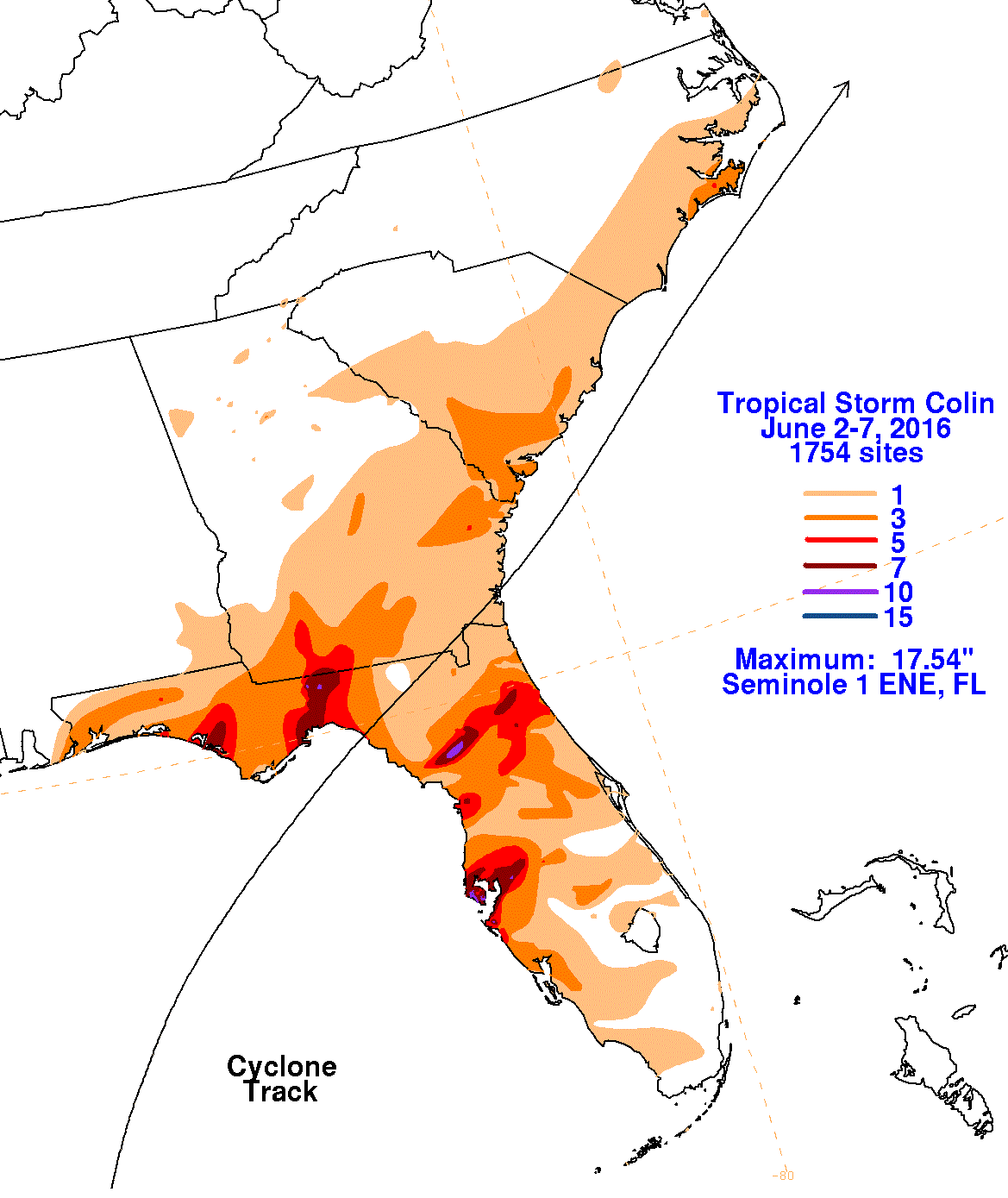
17.54 |
Seminole 1 ENE |
|
|
7.97 |
Marco Island CC |
D
|
3.81 |
High Springs |
|
|
10.90 |
Vero Beach 4 SE |
|
|
1.19 |
Tavernier |
|
|
5.80 |
La Belle |
|
|
11.26 |
Wewahitchka |
|
|
9.53 |
Wewahitchka |
|
|
4.85 |
Tamiami Trail 40 Mile Bend |
|
|
25.56 |
Ira Ebersole/Homestead |
|
|
8.70 |
Bristol 4 S |
|
|
3.89 |
West Palm Beach Int'l AP |
|
|
13.24 |
Railing Property |
|
|
23.73 |
Mayo |
|
|
1.95 |
Indiantown |
|
|
6.21 |
Palm Coast 4.5 SSW |
|
|
10.68 |
Fort Lauderdale |
E
|
9.36 |
Canal Point USDA |
|
|
16.36 |
Panama City 5 NE |
|
|
45.20 |
Yankeetown |
|
|
3.53 |
Crestview Radio WJSB |
|
|
7.64 |
Desoto City 8 SW |
|
|
15.67 |
Cross City 2 WNW |
|
|
4.99 |
Kendall 2 E |
|
|
14.90 |
Valparaiso/Eglin AFB |
|
|
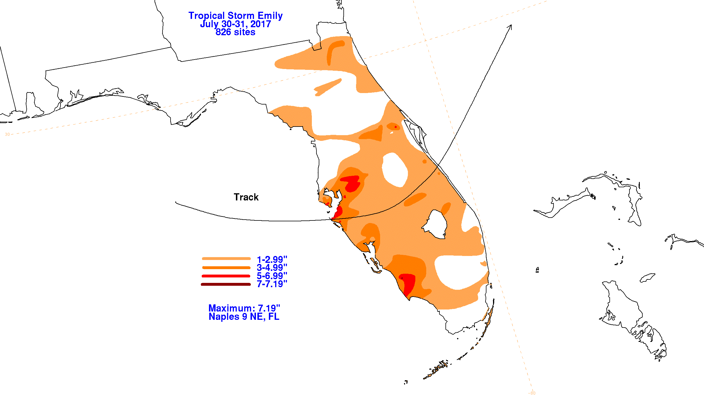
7.19 |
Naples 9 NE |
|
|
9.00 |
Sweetwater 14 NW |
|
|
10.84 |
Melbourne Regional AP |
|
|
8.72 |
South Golden Gate Estates |
|
|
8.11 |
Monticello 5 SW |
|
|
12.94 |
Milton Experiment Station |
F
|
4.19 |
Conch Key |
|
|
27.65 |
Melbourne 8 NW |
|
|
3.92 |
Naples |
|
|
6.29 |
South Miami 3 W |
|
|
12.28 |
Tyndall AFB |
|
|
15.79 |
Fellesmere 7 SSW |
|
|
9.51 |
Milton Experiment Station |
|
|
10.07 |
Fort Pierce |
|
|
3.88 |
Hastings Arc |
|
|
14.34 |
Pensacola Regional AP |
|
|
7.70 |
Fort Lauderdale Beach |
|
|
16.61 |
Kent Grove |
|
|
14.61 |
Navarre 4.1 ENE |
G
|
15.10 |
Parrish |
|
|
38.46 |
Munson |
|
|
4.65 |
Kendall 2 E |
|
|
1.32 |
St. Augustine |
|
|
12.46 |
Cape Kennedy AFS |
|
|
16.10 |
Cooperstown |
|
|
9.48 |
Mayo |
|
|
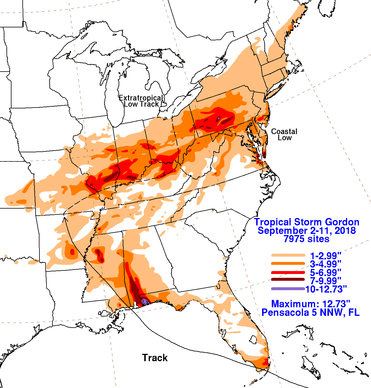
12.73 |
Pensacola 5 NNW |
|
|
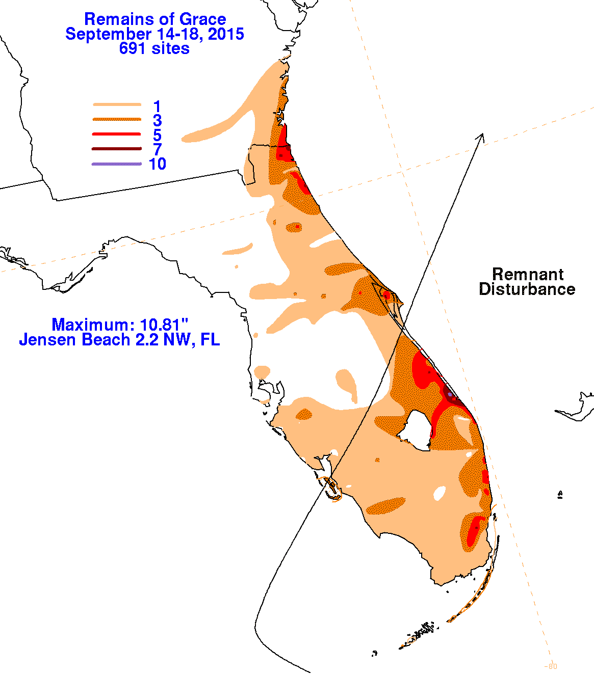
10.81 |
Jensen Beach 2.2 NW |
|
|
8.94 |
Fort Pierce |
|
|
Groundhog Day T. S. (Feb.
1952) |
4.35 |
Stuart |
|
4.12 |
Pensacola NAS, FL |
H
|
2.08 |
Pompano Beach |
|
|
9.67 |
Chipley 3 E |
|
|
6.50 |
South Bay 14 SSE |
|
|
10.24 |
Naples |
|
|
7.99 |
Pensacola |
|
|
10.53 |
Daytona Beach |
|
|
8.20 |
Tallahassee |
|
|
9.09 |
Hialeah |
|
|
14.14 |
Fort Lauderdale Beach |
|
|
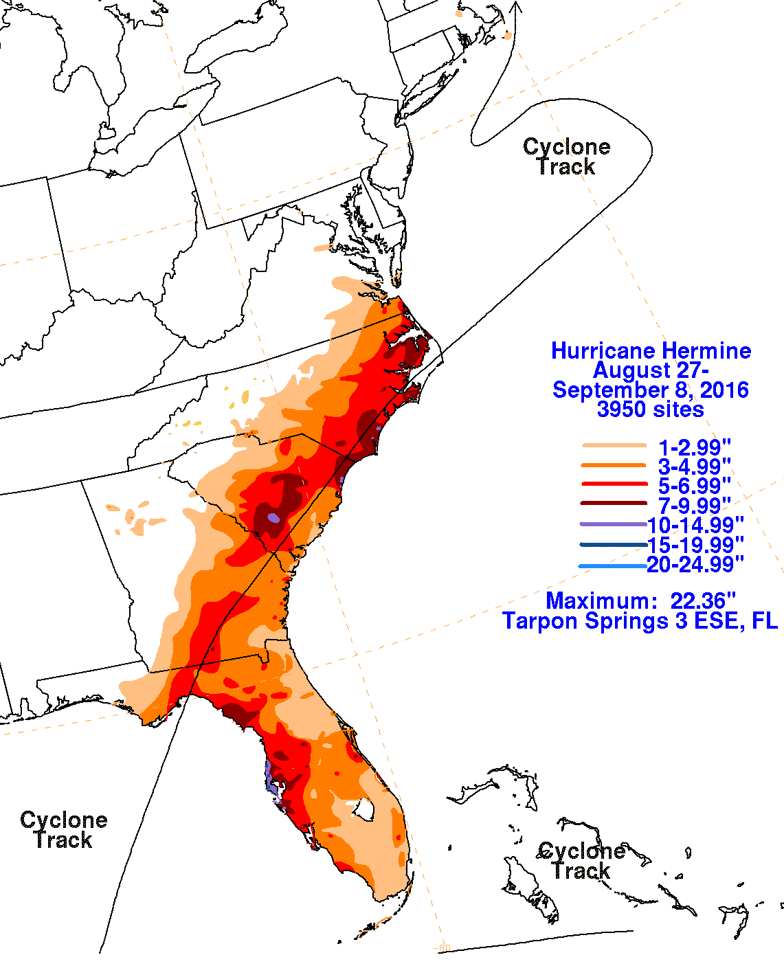
22.36 |
Tarpon Springs 3 ESE |
|
|
12.42 |
Wewahitchka |
|
|
How (Oct. 1951) |
15.72 |
Bonita Springs 2 ESE |
I
|
5.41 |
Pensacola 3.8 N |
|
|
6.34 |
Ochopee 1 NE |
|
|
4.80 |
Kendall 2 E |
|
|
Irene (Oct. 1959) |
7.69 |
Tyndall AFB |
|
17.45 |
Boynton Beach |
|
|
21.66 |
Fort Pierce Water Plant |
|
|
3.16 |
Deland 1 SSE |
|
|
9.46 |
West Palm Beach |
|
|
7.60 |
Loxahatchee |
|
|
11.31 |
Milton Experiment Station |
|
|
15.75 |
WEAR-TV Pensacola |
J
|
24.98 |
Key West Int'l AP |
|
|
11.97 |
Kenansville |
|
|
6.61 |
Deland 1 SSE |
|
|
18.33 |
West Palm Beach Plant
Intake |
|
|
11.39 |
Fernandina Beach |
|
|
11.71 |
Pensacola Forest Sherman
NAS |
|
|
7.90 |
Miles City Tower |
K
|
6.95 |
Panama City/Tyndall AFB |
|
|
8.32 |
Panama City |
|
|
16.43 |
Perrine |
|
|
10.27 |
St. Leo |
|
|
King (Oct. 1950) |
15.44 |
Patrick AFB |
L
|
10.27 |
St. Leo |
|
|
12.08 |
Upper Keys Station ENPBS |
|
|
Love (Oct. 1950) |
4.75 |
High Springs |
M
|
6.14 |
Bradenton 5 ESE |
|
|
3.29 |
Pensacola |
|
|
17.01 |
Cocoa Beach |
|
|
11.62 |
Lynn Haven 1.6 SSE |
|
|
4.99 |
S80 Rain Gage |
|
|
20.40 |
St. Petersburg 2.5 S |
|
|
11.20 |
Boca Raton |
N
|
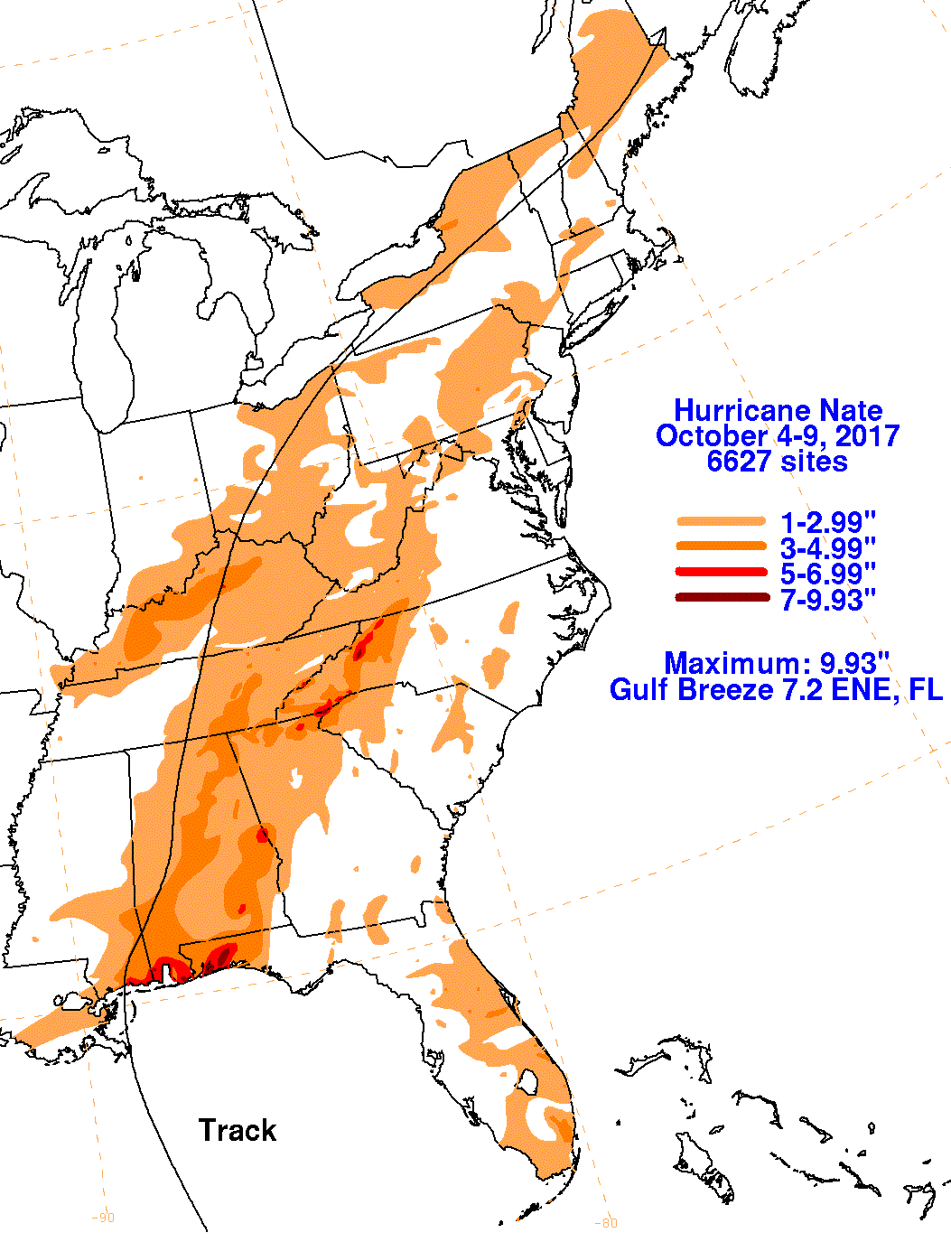
9.93 |
Gulf Breeze 7.2 ENE |
|
|
7.77 |
Baskin |
|
|
12.71 |
North Key Largo |
|
|
2.14 |
Perrine 4 W |
O
|
Oct. 3-7, 1948 Hurricane |
13.33 |
Pompano Beach |
|
7.08 |
Nettles Island |
|
|
15.52 |
Milton Experiment Station |
|
|
15.20 |
Indian Trails North/Palm Coast |
P
|
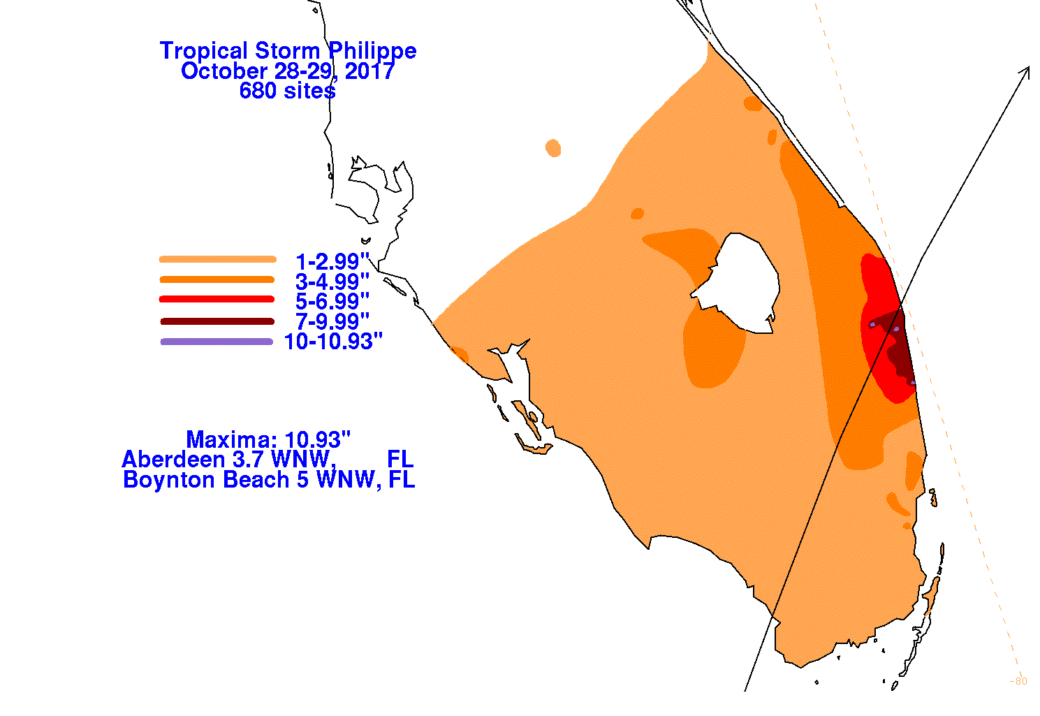
10.93 |
Aberdeen 3.7 WNW & Boynton Beach 5 WNW |
|
|
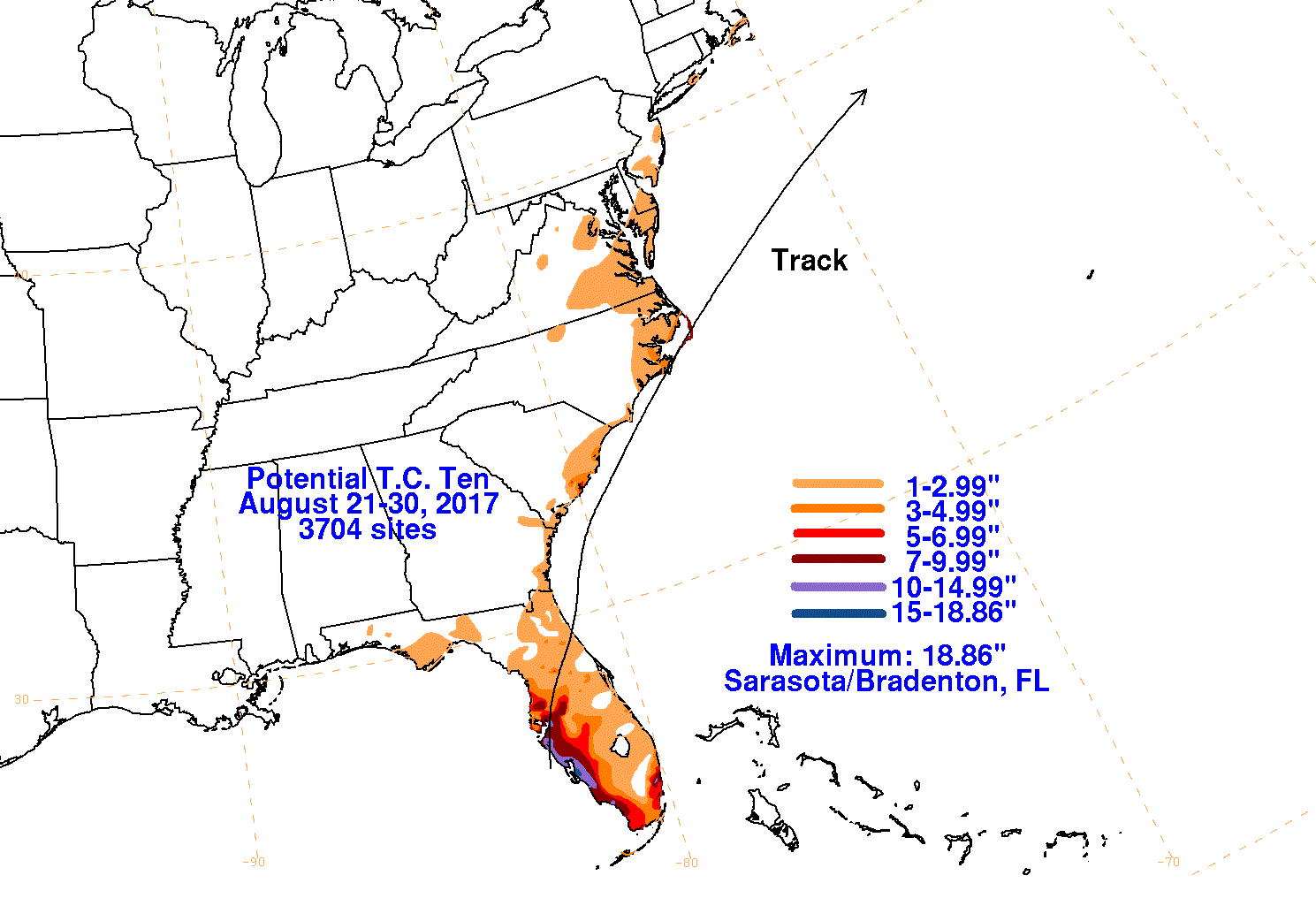
18.86 |
Sarasota/Bradenton |
Q
|
16.28 |
Kissimmee |
R
|
5.32 |
Tenraw/Everglades North
Park |
S
|
Sept. 19-23, 1948 Hurricane |
11.33 |
La Belle 2 NW |
|
Subtropical Storm
(Sep.-Oct. 1969) |
7.68 |
St. Augustine |
|
3.51 |
Jacksonville Int'l AP |
|
|
6.74 |
St. Augustine |
|
|
11.38 |
St. Petersburg AP |
|
|
5.75 |
Brooksville Chin Hill |
|
|
10.72 |
Desoto City 8 SW |
|
|
4.65 |
Homestead Exp. Stn |
|
|
14.00 |
Boca Raton |
T
|
4.83 |
Mayport Naval Station |
|
|
16.60 |
Sarasota |
|
|
2.40 |
La Belle |
|
|
1.78 |
Myakka River State Park |
|
|
5.27 |
West Palm Beach AP |
|
|
5.02 |
Jacksonville Beach |
|
|
3.18 |
Pompano Beach |
|
|
6.20 |
Royal Palm Ranger Station |
|
|
25.00 |
Arcadia Tower |
|
|
9.99 |
Canal Point USDA |
|
|
3.90 |
Carabelle 1 NNW |
|
|
7.20 |
Avon Park 2 W |
|
|
20.84 |
De Funiak Springs 1 E |
|
|
5.67 |
Moore Haven Lock #1 |
|
|
7.72 |
Homestead Exp. Station |
|
|
13.50 |
Myakka Rvr State Park |
|
|
5.74 |
Apalachicola |
|
|
7.29 |
Hastings Ag Center |
|
|
15.46 |
Jacksonville NAS |
|
|
5.85 |
High Springs |
|
|
5.73 |
Niceville |
|
|
6.74 |
Orlando Muni. AP |
|
|
4.81 |
Brooksville Chin Hill |
|
|
10.23 |
Loxahatchee NWR |
|
|
7.53 |
Royal Palm RS |
|
|
8.52 |
Key West Int'l AP |
|
|
23.40 |
Havana |
U
|
Unnamed (Aug.-Sep. 1953) |
8.61 |
Fort Lauderdale Beach |
|
Unnamed (Mid. Sep. 1953) |
14.85 |
Pompano Beach |
|
Unnamed (Early Oct. 1953) |
4.44 |
Dania 4 WNW |
|
7.42 |
Pensacola Weather Bureau
Office |
|
|
14.95 |
Perry |
|
|
13.04 |
N. Loxahatchee NWR |
|
|
9.40 |
Tavernier |
|
|
8.75 |
Wewahitchka |
|
|
12.26 |
Pensacola Regional AP |
W
|
13.26 |
Kennedy Space Center |